Related Research Articles

The Mascarene Islands or Mascarenes or Mascarenhas Archipelago is a group of islands in the Indian Ocean east of Madagascar consisting of the islands belonging to the Republic of Mauritius as well as the French department of La Réunion. Their name derives from the Portuguese navigator Pedro Mascarenhas, who first visited them in April 1512. The islands share a common geologic origin in the volcanism of the Réunion hotspot beneath the Mascarene Plateau and form a distinct ecoregion with a unique flora and fauna.
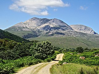
Beinn Eighe is a mountain massif in the Torridon area of Wester Ross in the Northwest Highlands of Scotland. Lying south of Loch Maree, it forms a long ridge with many spurs and summits, two of which are classified as Munros: Ruadh-stac Mòr at 1,010 m (3,314 ft) and Spidean Coire nan Clach at 993 m (3,258 ft). Unlike most other hills in the area it has a cap of Cambrian basal quartzite which gives the peaks of Beinn Eighe a distinctive light colour. Its complex topography has made it popular with both hillwalkers and climbers and the national nature reserve on its northern side makes it an accessible mountain for all visitors.
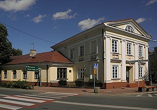
Grójec is a town in eastern Poland, located in the Masovian Voivodeship, about 40 kilometres south of Warsaw. It is the capital of the urban-rural administrative district Grójec and Grójec County. It has 16,674 inhabitants (2017). Grójec surroundings are considered to be the biggest apple-growing area of Poland. It is said that the region makes up also for the biggest apple orchard of Europe. Statistically, every third apple sold in Poland is grown in Grójec – a unique local microclimate provides for their beautiful red colour.

Ben Wyvis is a mountain in Easter Ross, in the northern Highlands of Scotland. It lies north-west of Dingwall, in the council area of Highland, and the county of Ross and Cromarty. Ben Wyvis is a large winding and undulating ridge running roughly north–south for about 5 km, the highest point of which is Glas Leathad Mòr at 1,046 metres (3,432 ft). Geologically, the ridge is composed of Moine pelitic gneiss. The mountain is prominent in views of the area, presenting a whale-back shape above the farmland of Strathconon.

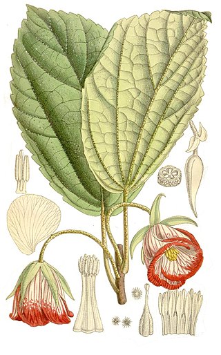
Hibiscus fragilis, the mandrinette, is an extremely rare shrub that is endemic to steep slopes of the mountains Corps de Garde and Le Morne Brabant on Mauritius and from two further plants on Rodrigues. The mandrinette is an evergreen plant with flowers 7–10 cm diameter with five bright pink to carmine red petals.
Trochetia is a genus of flowering plants from the family Malvaceae. They are endemic to the Mascarene Islands.

The South Western Slopes, also known as the South West Slopes, is a region predominantly in New South Wales, Australia. It covers the lower inland slopes of the Great Dividing Range, extending from north of Dunedoo through central NSW and into northeast Victoria, meeting its southwestern end around Beechworth. More than 90% of the region is in the state of New South Wales and it occupies about 10% of that state.
Morro Negro is a hill located near the east coast of the island of Boa Vista, Cape Verde. Its elevation is 156 m. The nearest village is Cabeça dos Tarrafes, 5.5 km to the northwest.
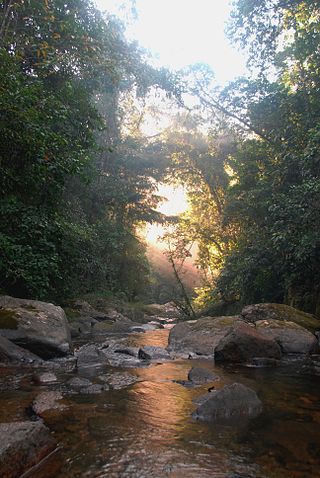
Pilea trilobata is an endemic Mauritian plant from the genus Pilea within the family Urticaceae. It was first described by botanist Hugh Algernon Weddell in 1854. It was thought to be extinct since 1849 until it was rediscovered in April 2005 in the Corps de Garde Nature Reserve.
The Islets of Mauritius includes circa a hundred and thirty tiny islets and rocks scattered around the coast of Mauritius, Rodrigues, Agalega and St Brandon.
The wildlife of Mauritius consists of its flora and fauna. Mauritius is located in the Indian Ocean to the east of Madagascar. Due to its isolation, it has a relatively low diversity of wildlife; however, a high proportion of these are endemic species occurring nowhere else in the world. Many of these are now threatened with extinction because of human activities including habitat destruction and the introduction of non-native species. Some have already become extinct, most famously the dodo which disappeared in the 17th century.
Ruizia parviflora is a very rare shrub from the family Malvaceae. It is endemic to Mauritius.
Blyde River Canyon Nature Reserve is situated in the Drakensberg escarpment region of eastern Mpumalanga, South Africa. The reserve protects the Blyde River Canyon, including sections of the Ohrigstad and Blyde Rivers and the geological formations around Bourke's Luck Potholes, where the Treur River tumbles into the Blyde below. Southwards of the canyon, the reserve follows the escarpment, to include the Devil's and God's Window, the latter a popular viewpoint to the lowveld at the reserve's southern extremity.
Bladen Nature Reservein Belize is a landscape of caves, sinkholes, streams and rivers, old growth rainforest and an abundance of highly diverse flora and fauna which includes a great deal of rare and endemic species.

De Hel Nature Area is a 21.3-hectare (53-acre) nature reserve protecting a river valley and indigenous forest on the lower eastern slopes of Table Mountain, Cape Town, South Africa.

Le Pouce is the third highest mountain in Mauritius, at 812 meters. Only Piton de la Petite Rivière Noire and Pieter Both are taller. It is named Le Pouce because of the thumb-shaped peak of the mountain. It can be viewed from the capital of Mauritius, Port Louis, and is a popular hike for the view of the city. The mountain is in the Moka Range and is closest to the village of La Laura-Malenga in the Moka District. Charles Darwin ascended the mountain on 2 May 1836.
The Eastern Arc forests is a montane tropical moist forest ecoregion of eastern Africa. The ecoregion comprises several separate highland areas above 800 meters in Kenya, and (mostly) Tanzania.

Ferney La Vallée is a forest and wildlife reserve situated in the Bambou mountains north of Mahébourg in Grand Port District, Mauritius. It is managed by the La Vallée de Ferney Conservation Trust.

The Samar Island Natural Park, in Samar, is the largest contiguous tract of old-growth forest in the Philippines. It is the country's largest terrestrial protected area, with an area of 333,300 hectares. The buffer is spread north to south over the island's three provinces and totals 458,700 hectares, about a third of the entire island of Samar.
References
- ↑ UNEP-WCMC (2021). Protected Area Profile for Corps de garde Nature reserve from the World Database of Protected Areas. Accessed 18 August 2021.