Costa del Maresme | |
---|---|
Dimensions | |
• Length | 55 km (34 mi) |
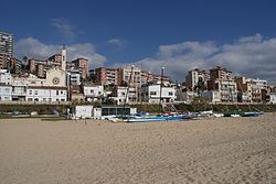
The Costa del Maresme is a section of the Catalan coast that coincides with the coast of the Maresme region and covers a total of sixteen municipalities from Montgat to the mouth of the Tordera (Malgrat de Mar). It is bordered on the north by the Costa Brava and on the south by the Costa de Barcelona.
The Costa del Maresme stretches between the Mediterranean Sea and the Catalan Coastal Range, which protects it from the north winds. The Costa del Maresme has extensive beaches, fishing villages and towns with a long history of tourism. Characterized by its mild climate and its Mediterranean landscape, it is a residential and tourist area that in recent decades has hosted many people from cities who have moved their first residence to the coast. [1] [2]
The region has five marinas and fishing activity is mainly concentrated in and around Arenys de Mar. For this reason, Arenys and Sant Pol de Mar have been distinguished as fishing villages by the Catalan Tourism Agency. [3]
The Costa del Maresme has a total of 54 beaches and caves [4] that add up to a length of 55 km (34 mi), most of them with medium and coarse sand.
They range from urban beaches - with all kinds of services like restaurants, bars and casinos - to more natural beaches far away from urban centers. Some have been awarded the Blue Flag, [5] others have been recognized as having a commitment to sustainability Biosphere [6] and others certified with the Q for Tourist Quality. [7] Some locations have also been certified as Family Beach destinations and offer facilities and services specially designed for family guests.
From southwest to northeast, they are:
Municipality | Name in Catalan | Name in English | Length | Notes (2019) | Pictures |
---|---|---|---|---|---|
Montgat [8] | (Cala Taps) | Taps Cove | 260 m | ||
Platja de les Roques | The Rocks Beach | 274 m | |||
Platja de les Barques | The Boats Beach | 500 m | |||
Platge de Can Tano | Can Tano Beach | 90 m | |||
Platja de Monsolís | Monsolís Beach | 660 m | |||
Platja dels Toldos | Toldos Beach | 383 m | |||
El Masnou [9] | Platja del Masnou | Masnou Beach | 1240m | ||
Platja d'Ocata (N) | Ocata Beach (N) | 2240m | |||
Premià de Mar [10] | Platja de Ponent i de la Descàrrega | Ponent and Descàrrega Beach | 690m | ||
Platja de Pla de l’Os i Bellamar | Pla de l'Os and Bellamar Beach | 860m | |||
Platja de Llevant | Llevant Beach | 595m | |||
Vilassar de Mar [11] | Platja de Ponent | Ponent Beach | 1160m | ||
Platja de l’Astillero | Astillero Beach | 960m | |||
Platja de l’Almadrava | Almadrava Beach | 290m | |||
Cabrera de Mar [12] | Platja dels Vinyals | Vinyals Beach | 600m | ||
Platja del Molí | Molí Beach | 500m | |||
Platja de Santa Margarida | Santa Margarida Beach | 200m | |||
Mataró [13] | Platja de Ponent | Ponent Beach | 180m | ||
Platja del Varador | Varador Beach | 765m | Q | ||
Platja del Callao | Callao Beach | 400m | Q | ||
Platja de Sant Simó | Sant Simó Beach | 1000m | |||
Sant Andreu de Llavaneres [14] | Platja de l’Estació | Beach of the Train Station | 200m | BCE | |
Platja de les Barques | Boats Beach | 180m | BCE | ||
Platja del Balís | Balís Beach | 50m | BCE | ||
Sant Vicenç de Montalt [15] | Platja Sant Vicenç de Montalt | Sant Vicenç de Montalt Beach | 1237m | BCE | |
Caldes d’Estrac [16] | Platja dels Tres Micos | Three Monkeys Beach | 400m | ||
Platja Kalima | Kalima Beach | 300m | |||
Arenys de Mar [17] | Platja de la Musclera (N) | Musclera Beach (N) | 630m | ||
Platja de la Picòrdia | Picòrdia Beach | 580m | |||
Platja del Cavaió | Cavaió Beach | 1000m | |||
Canet de Mar [18] | Platja del Cavaió | Cavaió Beach | 600m | ||
Platja de Canet | Canet Beach | 1500m | |||
Sant Pol de Mar [19] | Platja de les Roques Blanques | White Rocks Beach | 380m | ||
Platja de la Murtra | Murtra Beach | 500m | |||
Platja de Can Villar | Can Villar Beach | 700m | |||
Platja de Sant Pol | Sant Pol Beach | 400m | |||
Platja de les Barques | The Boats Beach | 150m | |||
Plata les Escaletes | The Stairs Beach | 300m | |||
Platja la Platjola | Platjola Beach | 130m | |||
Platja del Morer | Morer Beach | 750m | |||
Calella [20] | Platja de les Roques (N) | The Rocks Beach (N) | 736m | BCE | |
Platja de Garbí | Garbí Beach | 752m | / Q / BCE | ||
Platja Gran | The Big Beach | 1388m | BCE | ||
Pineda de Mar [21] | Platja Poblenou | Poblenou Beach | 634m | ||
Platja de la Riera | Creek Beach | 577m | / BCE | ||
Platja dels Pescadors | Beach of the Fishers | 1082m | / BCE | ||
Platja dels Pins (N) | Pinecone Beach (N) | 527m | |||
Santa Susanna [22] | Platja de les Dunes (N) | Dunes Beach (N) | 1000m | ||
Platja de les Caletes | Caletes Beach | 400m | |||
Platja de Llevant | Llevant Beach | 800m | BCE | ||
Malgrat de Mar [23] | Platja de l’Astillero | Astillero Beach | 1000m | ||
Platja Malgrat Centre | The Centre of Malgrat Beach | 900m | |||
Platja de la Conca | Conca Beach | 1700m | |||
Platja de la Punta de la Tordera (N) | Mouth of the Tordera Beach (N) | 900m |
There are a total of five ports along the cost with most of them of being meant for sporting.
From southwest to northeast, they are:
Port | Usage | Docks | Photo |
---|---|---|---|
Port del Masnou | Sporting | 1058 | |
Marina Port Premià | Sporting | 554 | |
Port de Mataró | Sporting | 1080 | |
Port Balís | Sporting | 764 | |
Port d'Arenys | Sporting and Fishing | 428 |
Mataró is the capital and largest town of the comarca of the Maresme, in the province of Barcelona, Catalonia Autonomous Community, Spain. It is located on the Costa del Maresme, to the south of Costa Brava, between Cabrera de Mar and Sant Andreu de Llavaneres, 30 kilometres north-east of Barcelona. As of 2010, it had a population of c. 122,932 inhabitants.
Trambesòs is a tram–light rail system in the Spanish autonomous community of Catalonia that links the Barcelona district of Sant Martí with Badalona and Sant Adrià de Besòs. Its name comes from the union of the words "tram", an abbreviation of the Catalan word for "tram" (tramvia), and "Besòs", the name of an area in the north of the Barcelonès region dominated by the Besòs River.
The Costa Brava is a coastal region of Catalonia in northeastern Spain, consisting of the comarques (counties) of Alt Empordà, Baix Empordà and Selva in the province of Girona. Costa Brava stretches from the town of Blanes, 60 km (37 mi) northeast of Barcelona, to the French border. In the 1950s, the Costa Brava was identified by the Spanish government and local entrepreneurs as being suitable for substantial development as a holiday destination, mainly for package holiday tourists from Europe. The combination of a very good summer climate, nature, excellent beaches and a favourable foreign exchange rate, which made Costa Brava an attractive tourist destination, was exploited by the construction of large numbers of hotels and apartments in such seaside resorts as Blanes, Tossa de Mar and Lloret de Mar. Tourism rapidly took over from fishing as the principal business of the area.
Lloret de Mar is a Mediterranean coastal town in Catalonia, Spain. It is 40 kilometres south of Girona and 75 kilometres northeast of Barcelona. With a population of 38,402 in 2021, it is the second largest town in the Selva comarca of Catalonia.
Calella is a municipality in the Maresme region, located 50 km from Barcelona, 50 km from Girona and 6 km from the Montnegre-Corredor Natural Park. It is known as the tourist capital of the Costa del Maresme and is characterized by being a cosmopolitan city with a typical Mediterranean climate.
L'Ametlla de Mar, also called la Cala, is a municipality within the comarca of Baix Ebre, situated in the coastal region between the "Cap de Terme" and the "barranc de l'Àliga". It is limited to the south by the boundary with El Perelló, to the north-west with that of Tivissa, the Ebro riviera, and to the north-east with that of Vandellós and l'Hospitalet de l'Infant,
Arenys de Mar is one of the main municipalities of the comarca of Maresme, Barcelona Province, Catalonia, Spain. It is situated on the coast between Caldes d'Estrac and Canet de Mar, about 40 kilometres northeast of Barcelona. As of 2010, it had a population of 14,688.
Premià de Mar is a municipality in the comarca of the Maresme in Catalonia, Spain. It is situated on the coast between El Masnou and Vilassar de Mar, to the north-east of Barcelona. The town is both a tourist centre and a dormitory town for Barcelona.
Santa Susanna is a municipality in the comarca of the Maresme in Catalonia, Spain. It is situated on the coast between Malgrat de Mar and Pineda de Mar. The main N-II road runs through the town.
Malgrat de Mar is a municipality in the comarca of the Maresme, in the province of Barcelona, Catalonia, Spain. It is situated on the Costa Brava between Santa Susanna and Blanes. A local road runs from the town to the main N-II road, while the B-682 connects it with Blanes, Lloret de Mar and Tossa de Mar. It is served by a RENFE railway station on the R1 line between Barcelona and Maçanet-Massanes.
Arenys de Munt is a municipality in the comarca of the Maresme in Catalonia, Spain. It is situated inland from the coast, in the el Corredor range and including the peak of el Montalt (595 m). It retains a textile industry specialised in the production of towels, and is also known for the production of strawberries, cherries and liqueurs. The B-511 road links the town with Arenys de Mar, Vallgorguina and Sant Celoni.
Caldes d'Estrac is a municipality in the comarca of Maresme in Catalonia, Spain. It is situated on the coast between Sant Vicenç de Montalt and Arenys de Mar. It is served by the main N-II road along the coast and by a station on the RENFE railway line.
Canet de Mar is a municipality in the comarca of the Maresme in Catalonia, Spain. It is situated on the coast between Arenys de Mar and Sant Pol de Mar. el Corredor and el Montnegre ranges. It is a tourist centre, but is also known for the cultivation of flowers and strawberries and for having several modernist style buildings. It is served by the main N-II road along the coast, the highway C-32 and by a station on the RENFE railway line. Canet de Mar is in the province of Barcelona (Spain), 43 kilometers from Barcelona.
Sant Pol de Mar is a municipality in the comarca of Maresme in Catalonia, Spain. It is located on the coast between Canet de Mar and Calella. The national highway N-II and a station on the RENFE railway line link Sant Pol de Mar to the rest of the coast, while a local road links the town with Arenys de Munt.
Sant Vicenç de Montalt, is a municipality in the comarca of the Maresme in Catalonia, Spain. It is situated on the coast between Sant Andreu de Llavaneres and Arenys de Mar, below the el Corredor range, with the main settlement slightly inland. The main N-II road along the coast passes through the municipality, linked to the town by a local road. There are also roads to Arenys de Munt and to Mataró, and a station on the RENFE railway line at Caldes d'Estrac.
Sant Cebrià de Vallalta is a municipality in the comarca of the Maresme in Catalonia, Spain. It is situated inland from the coast, in the valley of the Sant Pol river below the Montnegre range. A local road links the town with Arenys de Munt and with Sant Pol de Mar.
Sant Iscle de Vallalta is a municipality in the comarca of the Maresme in Catalonia, Spain. It is situated inland from the coast, in the valley of the Sant Pol river below the Montnegre range. A local road links the town with Arenys de Munt, Sant Cebria De Vallata and Sant Pol de Mar.
Sant Feliu de Guíxols is a municipality in the comarca of the Baix Empordà in Catalonia, Spain. It is situated on the Costa Brava and is an important port and tourist centre. The district abuts to the north, the upmarket s'Agaró resort built round the Sant Pol Beach. In addition to tourism and the port the cork industry is a traditionally local industry. The town contains a large monastery which now houses the town museum and is a protected historico-artistic monument. The C-253 road runs north along the coast to Platja d'Aro and Palamós, while the C-65 road runs inland from the town. The GI-682 provides a dramatic cliff top drive to Tossa de Mar to the south.
C-32 is a primary highway in Catalonia, Spain. It was created in 2004 by merging three sections of existing autopistas and autovías. This re-organisation was part of a renaming of primary highways managed by the Generalitat de Catalunya. According to this new denomination, the first number (C-32) indicates that is a southwest-northeast highway, while the second number (C-32) indicates that is the second-closest to the Mediterranean Sea.
The R1 is a line of Rodalies de Catalunya's Barcelona commuter rail service, operated by Renfe Operadora. It runs northwards from the Barcelona area to the southern limits of the province of Girona, passing through the coastal Maresme region. Since 2014, some services have been extended further north towards Portbou, near the French border. These services are designated RG1 and are considered part of the Girona commuter rail service. The line had an annual ridership of 28 million in 2016, achieving an average weekday ridership of 102,214 according to 2008 data.