Cottonwood Island (Nevada)

Last updated
Cottonwood Island
USA Nevada location map.svg
Red pog.svg
Cottonwood Island
Geography
LocationColorado River
Coordinates 35°25′08″N114°38′13″W / 35.41889°N 114.63694°W / 35.41889; -114.63694 Coordinates: 35°25′08″N114°38′13″W / 35.41889°N 114.63694°W / 35.41889; -114.63694
Length10 mi (20 km)
Width3 mi (5 km)
Administration
USA
StateNevada
CountyClark County
Demographics
Population0 (1869)

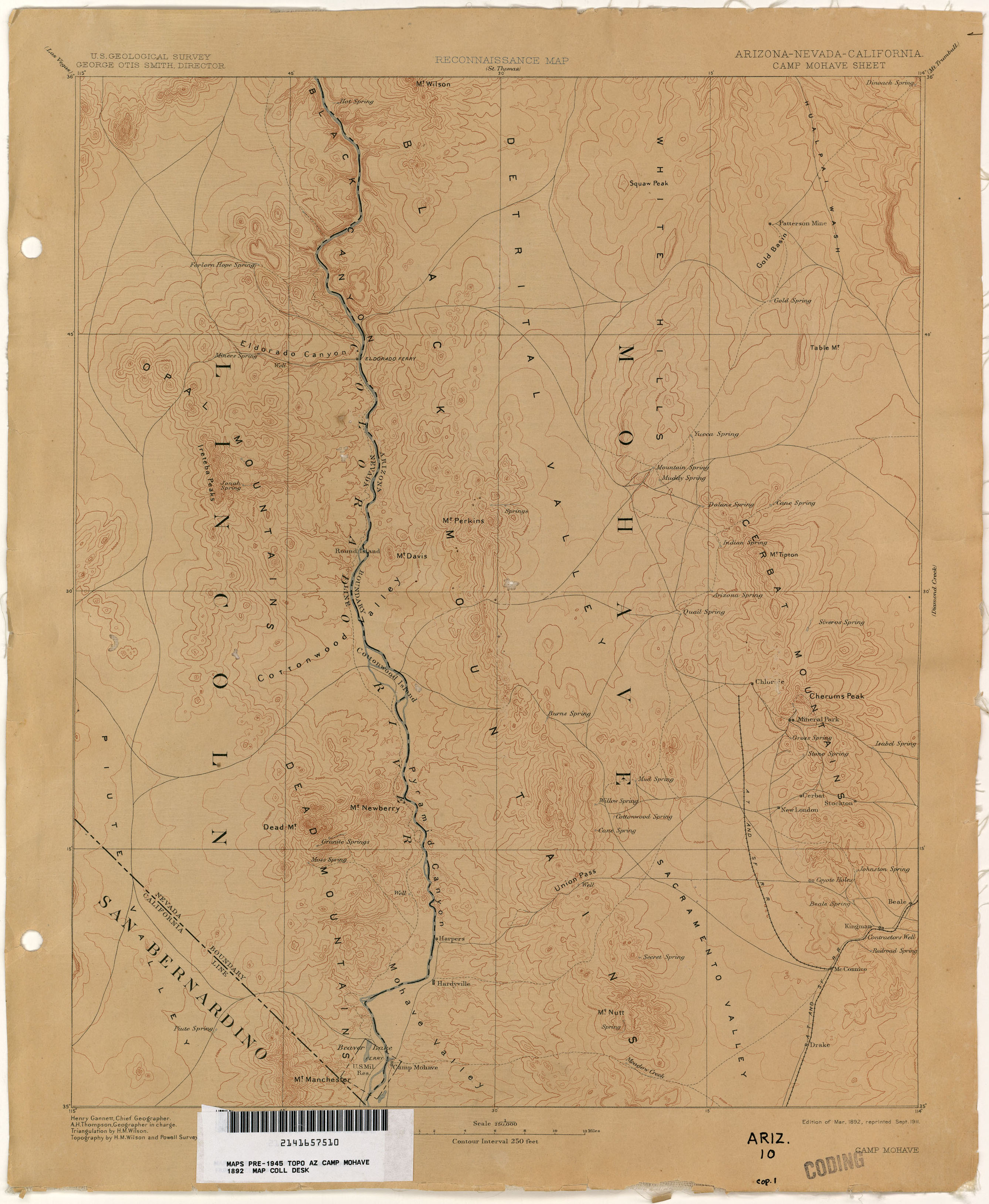
Cottonwood Island, a large island in the Colorado River, within Cottonwood Valley, in Clark County, Nevada. Cottonwood Island was a low-lying island about 10 miles long and up to 3 miles wide. It was forested by cottonwoods and also after the spring flood, cluttered with driftwood from the riparian woodlands along the upper watershed of the Colorado River, washed down and caught in the first wide valley where the river slowed and spread out. Cottonwood Island was important as a source wood and of fuel for steamboats on that river and for the early mills and mines in El Dorado Canyon.

Contents

John Ross Browne described it in his 1869 report on the Colorado River:

"Cottonwood island, about 10 miles long by an average of about three miles wide, is a fine, level island, fertile and covered with grass, and having considerable timber. Claims are said to have been located upon the land, but it is yet unoccupied. On the main land on both sides of the river opposite Cottonwood island are fine bottom lands, with good grass."
"A large quantity of driftwood of superior kind for fuel, composed mainly of pitch-pine and cedar, every year lodges at the head and along the sides of the island — sufficient, perhaps, alone, if taken care of, to furnish the fuel for years to steamboats passing on the Callville route. An immense quantity of this wood was upon the island, estimated at several thousand cords. The entire head of the island seemed to be formed of trunks of trees and sand washed in between them. The driftwood consists of trees, much broken up, of various sizes, not usually exceeding 14 inches in diameter." [1] :464

Cottonwood Island appears in the 1875 Topographical Sketch showing the Outward and Inward Route of a Party, while examining as to the practicability of a Diversion of the Colorado River for Purposes of Irrigation, from an annual report by 1st Lt. G. M. Wheeler, Corps Of Engineers. [2] Cottonwood Island later appears on a September 1911 reprint of a U. S. Geological Survey, Reconnaissance Map, Arizona, Nevada, California, Camp Mohave Sheet, Edition of March 1892, reprinted. [3]

History

Cottonwood Island was a site favored by the Mohave people for their agriculture, dependent as it was on the spring flood for its irrigation, and for the products they made from the cottonwood trees. It was an object of dispute with the Chemehuevi Paiute to the north and west, in the later 19th Century. [4]

All the driftwood deposited on the island became an item of trade following the establishment of mines in El Dorado Canyon in 1861. Wood was cut up by the Mohave and provided as fuel to steamboats traveling the river past Cottonwood Island or as timber for the mines. But such traffic only could occur during the high water months, the only time the steamboats would navigate the rapids and shallows of this upper reach of the Colorado. In late 1863 when the first stamp mill was established at the mines, ore was no longer carried down river in sufficient volume and the steamboats did not come as often. [5] :33,35 Additionally the need for more regular supplies of goods from down river at Hardyville, where the steamboats stopped at low water, and the need for more regular and large supplies for wood and wood fuel for the mills brought Captain L. C. Wilburn and a fleet of 3 barges, the Colorado, El Dorado and Veagas. These barges were sailed and poled up and down river by Paiute and Mohave crews during the slack months. They carried hay, timber, wood and charcoal made on the island up river to the mills in three or four days. [4] They also ascended the Colorado River as far as the Virgin River to bring back salt to the mills, for refining the ore, mined in the Virgin Valley by Mormon colonists there. [5] :35

The Island Today

Cottonwood Island is now lost under Lake Mohave.

Related Research Articles

<span class="mw-page-title-main">Bullhead City, Arizona</span> City in Mohave County, Arizona

Bullhead City is a city located on the Colorado River in Mohave County, Arizona, United States, 97 miles (156 km) south of Las Vegas, Nevada, and directly across the Colorado River from Laughlin, Nevada, whose casinos and ancillary services supply much of the employment for Bullhead City. Bullhead City is located at the southern end of Lake Mohave.

<span class="mw-page-title-main">Colorado River</span> Major river in the western United States and Mexico

The Colorado River is one of the principal rivers in the Southwestern United States and in northern Mexico. The 1,450-mile-long (2,330 km) river drains an expansive, arid watershed that encompasses parts of seven U.S. states and two Mexican states. The name Colorado derives from the Spanish language for "colored reddish" due to its heavy silt load. Starting in the central Rocky Mountains of Colorado, it flows generally southwest across the Colorado Plateau and through the Grand Canyon before reaching Lake Mead on the Arizona–Nevada border, where it turns south toward the international border. After entering Mexico, the Colorado approaches the mostly dry Colorado River Delta at the tip of the Gulf of California between Baja California and Sonora.

<span class="mw-page-title-main">Nelson, Nevada</span> Census-designated place in Nevada, United States

Nelson is a census-designated place in Clark County, Nevada, United States. The community is in the Pacific Standard Time zone. The location of Nelson is in El Dorado Canyon, Eldorado Mountains. The town is in the southeast region of the Eldorado Valley. As of the 2010 census it had a population of 37.

<span class="mw-page-title-main">Eldorado Mountains</span> Mountain range in Nevada, US

The Eldorado Mountains, also called the El Dorado Mountains, are a north-south trending mountain range in southeast Nevada bordering west of the south-flowing Colorado River; the endorheic Eldorado Valley borders the range to the west, and the range is also on the western border of the Colorado River's Black Canyon of the Colorado, and El Dorado Canyon on the river. The range is 50 miles (80 km) southeast of Las Vegas, Nevada; and the Eldorado Mountains connect with the Highland and Newberry mountains.

<span class="mw-page-title-main">El Dorado Canyon (Nevada)</span> Historic site in U.S. Highway near Nelson, Nevada

El Dorado Canyon is a canyon in southern Clark County, Nevada famed for its rich silver and gold mines. The canyon was named in 1857 by steamboat entrepreneur Captain George Alonzo Johnson when gold and silver was discovered here. It drains into the Colorado River at the former site of Nelson's Landing.

<span class="mw-page-title-main">Callville, Nevada</span> Human settlement in United States of America

Callville is a former settlement of Clark County in the U.S. state of Nevada. Abandoned in 1869, it was submerged under Lake Mead when the Colorado River was dammed, Callville Bay retaining the name. At one time, it was noted to be the southernmost outpost of the Mormon settlement.

<span class="mw-page-title-main">Steamboats of the Colorado River</span> Overview of steamboats on the Colorado River

Steamboats on the Colorado River operated from the river mouth at the Colorado River Delta on the Gulf of California in Mexico, up to the Virgin River on the Lower Colorado River Valley in the Southwestern United States from 1852 until 1909, when the construction of the Laguna Dam was completed. The shallow draft paddle steamers were found to be the most economical way to ship goods between the Pacific Ocean ports and settlements and mines along the lower river, putting in at landings in Sonora state, Baja California Territory, California state, Arizona Territory, New Mexico Territory, and Nevada state. They remained the primary means of transportation of freight until the advent of the more economical railroads began cutting away at their business from 1878 when the first line entered Arizona Territory.

General Jesup was a side-wheel paddle-steamer, named for General Thomas Jesup then Quartermaster General of the United States Army, and was the second steamboat launched on the Colorado River, in 1854.

Esmerelda, was a stern-wheel paddle-steamer, built for the Sacramento River trade, in 1864 it became the first of the opposition steamboats on the Colorado River. It was also the first steamboat to tow large cargo barges on that river, in May 1864 and to reach Callville, Nevada in 1866.

Mohave was the first stern-wheel steamboat of that name running on the Colorado River between 1864 and 1875.

Louisville, which is now a ghost town, was a mining camp in El Dorado Canyon near the Techatticup Mine in the Eldorado Mining District, of New Mexico Territory. The camp was probably named for Nat S. Lewis, the superintendent of the Techatticup Mine in the 1860s, and camp doctor.

El Dorado City, which is now a ghost town, was a mining camp in the Colorado Mining District at the mouth of January Wash at its confluence with El Dorado Canyon. It was located about a mile down the canyon from Huse Spring, at an elevation of 2382 feet. Its site was located nearby to the south southeast of the Techatticup Mine the primary source of the ore its mill processed.

Colorado City is now a ghost town, in Clark County, Nevada, located under Lake Mohave at the mouth of El Dorado Canyon.

Stone's Ferry is a former settlement founded by members of the Church of Jesus Christ of Latter-day Saints and ferry crossing of the Colorado River between Nevada and Arizona, in Clark County, Nevada, United States.

Beaver Lake was a lake on the west side of the Colorado River in what is now Clark County, Nevada. Beaver Lake lay on a north–south axis, almost entirely within the boundaries of the Camp Mohave Military Reservation. The southern end of the lake was a mile and half west of Fort Mohave and its northern end was located about 2 miles northwest of the camp. The Mojave Road passed by the northern extremity of the lake. Since 1892 the lake has dried up and have returned to desert or been made into farmland. It appears as a depression running north and south, west of the river at an elevation of 490 feet or less.

Colorado Mining District was primarily a silver and gold mining district organized in El Dorado Canyon, New Mexico Territory on the west shore of the Colorado River in what is now Clark County, Nevada. The Colorado District was part of Arizona Territory from 1863 to 1869. In 1869, the land of Arizona Territory north and west of the Colorado River east to the 114th meridian of longitude, including the Colorado District, was turned over to Nevada.

John Thomas Moss was an American frontiersman, prospector, and miner, who discovered several new mining districts in what is now Arizona and Nevada. After living with and learning the languages of many of the tribes in the area, he was a go between and peacemaker between American miners and local Native Americans, in the Southwestern United States.

George A. Johnson & Company was a partnership between three men who pioneered navigation on the Colorado River. Benjamin M. Hartshorne, George Alonzo Johnson and Alfred H. Wilcox. The George A. Johnson & Company was formed in the fall of 1852, and was reorganized as the Colorado Steam Navigation Company in 1869.

Quartette or Quartette Mill or Quartette Landing, was a mining settlement, location of the stamp mill of the Quartette Mining Company, owner of the largest mine in the Searchlight Mining District and a steamboat landing on the Colorado River, in what is now Clark County, Nevada. It lay at an elevation of 646 feet.

Lane's Crossing was a ford below the Lower Narrows of the Mojave River in San Bernardino County, California, United States. "Lane's", a ranch and store for travelers at this crossing on the Mormon Road, was established by "Captain" Aaron G. Lane the first pioneer settler on the Mojave River.

References

  1. John Ross Browne, Resources of the Pacific Slope. A Statistical And Descriptive Summary Of The Mines And Minerals, Climate, Topography, Agriculture, Commerce, Manufactures, And Miscellaneous Productions, Of The States And Territories West Of The Rocky Mountains. With a Sketch of the Settlement and Exploration of Lower California, D. Appleton & Company, New York, 1869
  2. Topographical Sketch showing the Outward and Inward Route of a Party, while examining as to the practicability of a Diversion of the Colorado River for Purposes of Irrigation, Lithograph by Eric Bergland, 1875. From, Wheeler, G.M., Topographical Atlas Projected To Illustrate United States Geographical Surveys West Of The 100th Meridian Of Longitude Prosecuted In Accordance With Acts Of Congress Under The Authority Of The Honorable The Secretary Of War, And The Direction Of Brig. Genl. A.A. Humphreys, Chief Of Engineers, U.S. Army. Embracing Results Of the Different Expeditions Under The Command Of 1st Lieut. Geo. M. Wheeler, Corps Of Engineers. Julius Bien, lith., G. Thompson, Washington, 1876, From a Wheeler Annual Report. Gift to the David Rumsey collection by Mark Sappington. From davidrumsey.com, accessed June 22, 2015
  3. U. S. Geological Survey, Reconnaissance Map, Arizona, California, Nevada, Camp Mohave Sheet, Edition of Mar. 1892, reprinted Sept. 1911 from lib.utexas.edu accessed June 14, 2015.
  4. 1 2 Daily Alta California, Volume 18, Number 5922, 28 May 1866 p.1 col. 5-6 OUR ARIZONA CORRESPONDENCE, Up The Colorado, (from the Correspondent of the Alta California), El Dorado Canyon, April 30th, 1866, Alling (Frank S. Alling), See, Irataba's Defeat from cdnc.ucr.edu accessed June 16, 2015.
  5. 1 2 Richard E. Lingenfelter, Steamboats on the Colorado River, 1852-1916, University of Arizona Press, Tucson, 1978 Archived January 18, 2016, at the Wayback Machine