
Nashville is the capital and most populous city of the U.S. state of Tennessee, and the seat of Davidson County. With a population of 689,447 at the 2020 U.S. census, Nashville is the 21st most-populous city in the United States, and the fourth most populous city in the southeastern U.S. Located on the Cumberland River, the city is the center of the Nashville metropolitan area, and is one of the fastest growing in the nation.

Wilson County is a county in the U.S. state of Tennessee. It is in Middle Tennessee. As of the 2020 census, the population was 147,737. Its county seat is Lebanon. The largest city is Mt. Juliet. Wilson County is part of the Nashville-Davidson–Murfreesboro–Franklin, TN Metropolitan Statistical Area.

Rutherford County is a county located in the U.S. state of Tennessee. It is located in Middle Tennessee. As of a 2021 estimate, the population was 352,182, making it the fifth-most populous county in Tennessee. A study conducted by the University of Tennessee projects Rutherford County to become the third largest county in Tennessee by population by 2050. Its county seat is Murfreesboro, which is also the geographic center of Tennessee. As of 2010, it is the center of population of Tennessee. Rutherford County is included in the Nashville-Davidson–Murfreesboro–Franklin, TN Metropolitan Statistical Area.

Davidson County is a county in the U.S. state of Tennessee. It is located in the heart of Middle Tennessee. As of the 2020 census, the population was 715,884, making it the second most populous county in Tennessee. Its county seat is Nashville, the state capital and largest city.
The Nashville Basin, also known as the Central Basin, is a term often used to describe the area surrounding Murfreesboro, Tennessee, in which Nashville is located. The Central Basin was caused by an uplifting which produced a dome known as the Nashville Dome. The Nashville Dome is evidenced by the underlying rock strata that all dip downwards away from Nashville. The uplifting of the Nashville Dome fractured overlying strata, making it more easily eroded and thus the "dome" resulted in a "basin". Uplifted strata in the center of a geological dome have higher potential erosive energy than the surrounding strata, because they are physically higher. Erosion thus acts on the uplifted area at a greater rate than on the surrounding flat-lying area, creating a low area, i.e. a basin. This area is more correctly referred to as the "Central Dome" of Tennessee.

The Harpeth River, 115 miles (185 km) long, is one of the major streams of north-central Middle Tennessee, United States, and one of the major tributaries of the Cumberland River. Via the Cumberland and the Ohio Rivers, it is part of the Mississippi River watershed. The lower portion of the Harpeth is designated as a "scenic river" under the Tennessee Scenic Rivers Act.

Madison is a former settlement, now a suburban neighborhood of northeast Nashville, in the U.S. state of Tennessee. It is incorporated as part of the Metropolitan Government of Nashville and Davidson County.

Donelson is a neighborhood of Nashville, Tennessee about 6 mi (10 km) east of downtown Nashville along U.S. Route 70. It is named in honor of John Donelson, co-founder of Nashville and father-in-law of Andrew Jackson, Nashvillian and seventh President of the United States. It is now incorporated as part of the Metropolitan Government of Nashville and Davidson County.
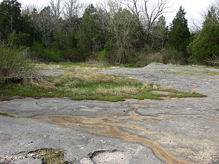
A calcareous glade is a type of ecological community that is found in the central Eastern United States. Calcareous glades occur where bedrock such as limestone occurs near or at the surface, and have very shallow and little soil development. Due to the shallow soil and the extreme conditions created by it, trees are often unable to grow in the glades. This creates a habitat that is usually sunny, dry, and hot. Calcareous glade vegetation is more similar to that of a desert habitat than a grassland, being dominated by small spring annuals with occasional geophytic or succulent perennials.
The Nashville metropolitan area is a metropolitan statistical area centered on Nashville, Tennessee, the capital and largest city in Tennessee, in the United States. With a population of just over 2 million, it is the most populous metropolitan area in Tennessee. It is also the largest metropolitan area in Tennessee, in terms of land area.

Eriogonum longifolium var. harperi, also known as Harper's buckwheat or Harper's umbrella plant, is a dicot of the family Polygonaceae, found in areas of nutrient-poor shale soils in Alabama, Kentucky and Tennessee. It lives inconspicuously in an immature vegetative stage for four or more years before developing a flowering stalk, then flowers and dies. It is listed as an endangered species by the state of Tennessee. It has eleven small populations in Alabama and five in Tennessee but its survival in Kentucky is uncertain. According to a leading expert, Professor James L. Reveal of the University of Maryland, its Kentucky population has been reportedly extirpated. Its 2006 Alabama Natural Heritage Program ranking was G4T2S1, demonstrating an opinion that it was "critically imperiled" in that state.
The Louisville and Nashville Turnpike was a toll road that ran from Louisville, Kentucky to Nashville, Tennessee during the 19th century. From Louisville, one route now designated US 31W ran through Elizabethtown, Munfordville, Glasgow Junction, Bowling Green, and Franklin before crossing into Tennessee. In Tennessee, the route would continue through Portland, Cross Plains, Millersville and Goodlettsville before going into Nashville. The other route ran through Bardstown, Buffalo, Glasgow, and Scottsville and is currently named US 31E. The name survives in abbreviated form along routes including Kentucky State Routes 335 and 470. US 31W is usually named for the Dixie Highway which succeeded the Turnpike.

Long Hunter State Park is a state park in Davidson County and Rutherford County, Tennessee, located in the southeastern United States. The park is mostly situated along the eastern shores of Percy Priest Lake, an artificial lake created by an impoundment of the Stones River.
Old Hickory Boulevard is a historic road that encircles Nashville, Tennessee, lying entirely within Davidson County. Originally the road, aided by ferries, formed a nearly unbroken loop around the city. Today, it is interrupted by a lake and several rerouted sections, which consist of roughly 69 miles (111 km). Just over half the distance–36.2 miles (58.3 km)–is part of several Tennessee state highways, including SR 45, SR 171, SR 251, and SR 254. Unsigned concurrencies exist very briefly along US 31E, US 41/US 70S, and SR 100.

State Route 45 is a west–east route in Davidson County, Tennessee. It connects US 431 in Whites Creek with I-40 in Hermitage.

Cedars of Lebanon State Park is a state park in Wilson County, Tennessee, in the southeastern United States. It consists of 900 acres (364 ha) situated amidst the 9,420-acre (3,810 ha) Cedars of Lebanon State Forest. The park and forest are approximately 10 miles (16 km) south of Lebanon, Tennessee.
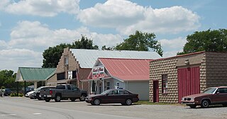
Gladeville is an unincorporated community in Wilson County, Tennessee. The community is named for the surrounding cedar glades— a unique type of ecosystem that thrives in the thin or barren soil of south Wilson County. Gladeville is located just off Interstate 840 along Stewarts Ferry Pike, approximately 10 miles (16 km) southeast of Mt. Juliet.

The Interior Low Plateaus are a physiographic region in eastern United States. It consists of a diverse landscape that extends from north Alabama across central Tennessee and Kentucky into southern Illinois, Indiana, and Ohio. Its natural communities are a matrix of temperate forests, woodlands, and prairies.

Couchville Cedar Glade State Natural Area is a Class II Natural-Scientific state natural area located in Davidson and Wilson counties Tennessee. Its western boundary is contiguous with the eastern boundary of Long Hunter State Park. The park's name reflects its location near the now extinct inundated community of Couchville, Tennessee.

Vine is an unincorporated community in Wilson County, 12.9 miles (20.7 km) south of Lebanon in the U.S. state of Tennessee. It is located along U.S. Route 231, SR 10, and SR 452. Boundaries for the community are imprecise but typically considered to be the communities of Gladeville to the west, Vesta to the north, Norene to the east, and Silver Hill to the south in Rutherford County. It shares the assigned zip code of 37090 with the rest of southern Wilson County.
