Council Offices, Welwyn Garden City

Last updated

Council Offices, Welwyn Garden City
Welwyn Hatfield Borough Council Offices.jpg
Council Offices, Welwyn Garden City
LocationThe Campus, Welwyn Garden City
Coordinates 51°48′15″N0°12′20″W / 51.8041°N 0.2055°W / 51.8041; -0.2055
Built1937
Architect Cecil Harry Elsom
Architectural style(s) Neo-Georgian style
Hertfordshire UK location map.svg
Red pog.svg
Shown in Hertfordshire

The Council Offices, also known as the Welwyn Hatfield Borough Council Offices, is a municipal building on The Campus in Welwyn Garden City, Hertfordshire, England. The structure accommodates the offices and meeting place of Welwyn Hatfield Borough Council.

History

After Sir Ebenezer Howard initiated the development of a garden city at a site a mile south of the village of Welwyn in 1920, the Canadian town planner, Louis de Soissons, was asked to prepare a masterplan for the area. That masterplan envisaged a long boulevard on a north–south axis with a semi-circular green, which would be known as The Campus, at the north end. After the parish of Welwyn Garden City was made an urban district on 1 April 1927, making it independent of the Welwyn Rural District Council, [1] the new civic leaders decided to commission a civic complex around The Campus. The new council offices were designed by Cecil Harry Elsom in the Neo-Georgian style, built in red brick and were officially opened on 6 January 1937. [2] [3] [4]

The complex also included a fire station, erected immediately to the southeast, of the council offices, [5] and a new public library equipped with 18,000 books, although the library service relocated to Guessens Road in autumn 1939. [6]

The design involved a symmetrical main frontage of seven bays facing onto The Campus. The central bay featured a square headed doorway with an architrave and a wide stone surround flanked by stone piers supporting a balcony with iron railings and finials. There was a French door, which allowed access to the balcony, in the central bay on the first floor. The other bays were fenestrated by sash windows on both floors and, projecting from the hipped roof, there were five flat roofed dormer windows. There was also a central clock tower with an ogee-shaped roof and a weather vane. Internally, the principal room was the council chamber on the first floor. [7]

During the Second World War, air raid wardens were posted on the roof to watch out for incendiary bombs. [8] The building continued to serve as the offices of the urban district council for much of the 20th century, and then became the headquarters of the enlarged Welwyn Hatfield District Council when it was formed in 1974. [9] After the fire service moved to Bridge Road East in 1978, the council offices were extended to the southeast and to the north. [10] [11] The council chamber was refurbished by Borras Construction at a cost of £712,000, to a design by RPS Group, in 2016. [12] [13]

Related Research Articles

<span class="mw-page-title-main">Hatfield, Hertfordshire</span> Town in Hertfordshire, England

Hatfield is a town and civil parish in Hertfordshire, England, in the borough of Welwyn Hatfield. It had a population of 29,616 in 2001, 39,201 at the 2011 Census, and 41,265 at the 2021 Census. The settlement is of Saxon origin. Hatfield House, home of the Marquess of Salisbury, forms the nucleus of the old town. From the 1930s when de Havilland opened a factory, until the 1990s when British Aerospace closed it, aircraft design and manufacture employed more people there than any other industry. Hatfield was one of the post-war New Towns built around London and has much modernist architecture from the period. The University of Hertfordshire is based there.

<span class="mw-page-title-main">Hertfordshire</span> County of England

Hertfordshire is one of the home counties in southern England. It borders Bedfordshire to the north, Cambridgeshire to the north-east, Essex to the east, Greater London to the south, and Buckinghamshire to the west and the south-west. For government statistical purposes, it forms part of the East of England region.

<span class="mw-page-title-main">Welwyn Hatfield</span> Place in England

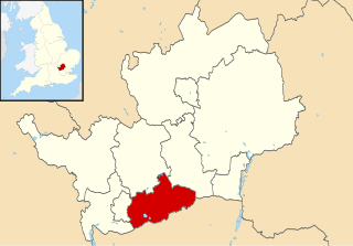
Welwyn Hatfield is a local government district with borough status in the county of Hertfordshire, England. Its council is based in Welwyn Garden City. The borough borders Hertsmere, St Albans, North Hertfordshire, East Hertfordshire, Broxbourne, and the London Borough of Enfield.

<span class="mw-page-title-main">Welwyn Garden City</span> Town in Hertfordshire, England

Welwyn Garden City is a town in Hertfordshire, England, 20 miles (32 km) north of London. It was the second garden city in England and one of the first new towns. It is unique in being both a garden city and a new town and exemplifies the physical, social and cultural planning ideals of the periods in which it was built.

<span class="mw-page-title-main">St Albans City and District</span> Local authority district in England

St Albans, commonly known as the City and District of St Albans, is a local government district with city status in Hertfordshire, England. Its council is based in St Albans, the largest settlement in the district. The district also includes the town of Harpenden and several villages. The district borders North Hertfordshire, Welwyn Hatfield, Hertsmere, Watford, Three Rivers, Dacorum, and Central Bedfordshire.

<span class="mw-page-title-main">Hertsmere</span> Place in England

Hertsmere is a local government district with borough status in Hertfordshire, England. Its council is based in Borehamwood. Other settlements in the borough include Bushey, Elstree, Radlett and Potters Bar. The borough contains several film studios, including Elstree Studios and the BBC Elstree Centre at Borehamwood. The borough borders Three Rivers, Watford, St Albans, and Welwyn Hatfield in Hertfordshire and the three north London boroughs of Harrow, Barnet and Enfield. Hertsmere is located mainly within the M25 Motorway.

<span class="mw-page-title-main">Northaw and Cuffley</span> Human settlement in England

Northaw and Cuffley is a civil parish in the Welwyn Hatfield borough of Hertfordshire, England. Located approximately 13.5 miles (21.7 km) north of central London and adjacent to the Greater London boundary, it is a partly urbanised parish with large sections of open land. Northaw and Cuffley is a recent renaming of the ancient parish of Northaw, covering the settlements of Northaw and Cuffley. The local council is Northaw and Cuffley Parish Council.

<span class="mw-page-title-main">Digswell</span> Human settlement in England

Digswell is an ancient village and former parish in the English county of Hertfordshire which is recorded in the 1086 Domesday Book. The population of the urban area of Digswell in the 2011 Census was 1,632.

One third of Welwyn Hatfield Borough Council in Hertfordshire, England is elected each year, followed by one year without election. Since the last boundary changes in 2016 the council has comprised 48 councillors representing 16 wards, each of which elects three councillors.

<span class="mw-page-title-main">Hatfield Rural District</span> Rural district in Hertfordshire, England

The 2004 Welwyn Hatfield District Council election took place on 10 June 2004 to elect members of Welwyn Hatfield District Council in Hertfordshire, England. One third of the council was up for election and the Conservative Party stayed in overall control of the council.

Welwyn is a village and civil parish in Hertfordshire, England.

<span class="mw-page-title-main">Watford Town Hall</span> Municipal building in Watford, Hertfordshire, England

Watford Town Hall is a municipal building in Rickmansworth Road, Watford, England. It is a Grade II listed building.

<span class="mw-page-title-main">The Town Hall, Christchurch</span> Municipal building in Christchurch, Dorset, England

The Town Hall, Christchurch is a municipal building in Christchurch, Dorset, England. The building, which incorporates a room known as the mayor's parlour on the first floor, and is a Grade II listed building. It is currently the base of Christchurch Town Council.

<span class="mw-page-title-main">Bridlington Town Hall</span> Municipal building in Bridlington, East Riding of Yorkshire, England

Bridlington Town Hall is a municipal building in Quay Road, Bridlington, East Riding of Yorkshire, England. The town hall, which was the meeting place of Bridlington Borough Council, is a Grade II listed building.

<span class="mw-page-title-main">Letchworth Town Hall</span> Municipal building in Letchworth, Hertfordshire, England

Letchworth Town Hall is a municipal building in Broadway, Letchworth, Hertfordshire, England. The town hall, which was the headquarters of Letchworth Urban District Council, is a Grade II listed building.

<span class="mw-page-title-main">Tring Market House</span> Municipal building in Tring, Hertfordshire, England

Tring Market House is a municipal building in the High Street, Tring, Hertfordshire, England. The structure, which is the meeting place of Tring Town Council, is a Grade II listed building.

<span class="mw-page-title-main">Municipal Offices, High Wycombe</span> Municipal building in High Wycombe, Buckinghamshire, England

The Municipal Offices are located on Queen Victoria Road in High Wycombe, Buckinghamshire, England. The structure is used as the High Wycombe local area office of Buckinghamshire Council.

References

  1. Registrar General (1927). Statistical Review of England and Wales. London: His Majesty's Stationery Office. p. 122. Retrieved 17 September 2021. Ministry of Health Order No. 71,611 – The Hertfordshire (Welwyn Garden City Urban District) Confirmation Order, 1927
  2. "Council Offices, Welwyn Garden City, Hertfordshire (Exterior)". Royal Institute of British Architects. Retrieved 11 October 2023.
  3. New Council Offices, Hertfordshire Mercury (Hertford), 8 January 1937, page 7
  4. Clapson, Mark (2020). Live, Work and Play A Centenary History of Welwyn Garden City. The History Press. ISBN   978-0750995313.
  5. Welwyn Garden City Public Buildings. Vol. 91. The Surveyor. 29 January 1937. p. 196. New Council Offices and Fire Station. Welwyn Garden City, Herts, came into formal possession of new public offices and a fire station on the 6th inst.
  6. Rabbitts, Paul; Jeffree, Peter (2021). Welwyn & Welwyn Garden City in 50 Buildings. Amberley Publishing. ISBN   978-1398102484.
  7. "Council Offices, Welwyn Garden City, Hertfordshire (Interior)". Royal Institute of British Architects. Retrieved 11 October 2023.
  8. "Grandparents came to Welwyn Garden City in 1920". Hertfordshire County Council. Retrieved 11 October 2023.
  9. Local Government Act 1972. 1972 c.70. The Stationery Office Ltd. 1997. ISBN   0-10-547072-4.
  10. "Council Offices". Welwyn Garden City Heritage Trail. Retrieved 11 October 2023.
  11. "Welwyn Garden City Conservation Area Appraisal". Welwyn Hatfield Borough Council. 1 September 2007. p. 18. Retrieved 11 October 2023.
  12. "New £712K Welwyn Hatfield Council chamber looks set to get the go ahead". Welwyn Hatfield Times. 19 November 2015. Retrieved 11 October 2023.
  13. "Welwyn Borough Council Chamber" (PDF). Acoustic Products. Retrieved 11 October 2023.