Counter's Creek

Last updated

Lots Road Power Station where Counter's Creek joins the Thames as Chelsea Creek Lots Road Power Station, Chelsea Wharf - geograph.org.uk - 1380741.jpg
Lots Road Power Station where Counter's Creek joins the Thames as Chelsea Creek

Counter's Creek, ending in Chelsea Creek, the lowest part of which still exists, was a stream that flowed from Kensal Green, by North Kensington and flowed south into the River Thames on the Tideway at Sands End, Fulham. Its remaining open watercourse is the quay of Chelsea Creek.

Contents

Course

A brick bridge over Counter's Creek shown in a 1675 map by John Ogilby. Holland House in an Ogilby map 1675.jpg
A brick bridge over Counter's Creek shown in a 1675 map by John Ogilby.

Counter's Creek flowed from Kensal Green, by North Kensington at the confluence of two small headwaters that rose just west of Ladbroke Grove and entered the stream close to Latimer Road just south of St Quintin Avenue. [1] The stream flowed south through Kensal Green Cemetery, Little Wormwood Scrubs, North Kensington, past Shepherd's Bush to one side and the Olympia part of Kensington on the other [2] and then past Earl's Court and Old or West Brompton on the other. As a vestige, an overflow verdant ditch exists beside Platform 4 (trains to Olympia) of West Brompton Underground Station. It passes Brompton Cemetery and Chelsea F.C. ground at Stamford Bridge. On the left bank where the creek meets the Thames is the former Lots Road Power Station. The tidal mouth is a watercourse, connecting to the Thames with boat moorings and is shown on modern maps as Chelsea Creek; this part of Fulham is sometimes known by the toponym "Sands End". [3] [4] [5] [6]

History

The Kensington Canal 1850 aka Counter's Creek Kensington Canal 1850.gif
The Kensington Canal 1850 aka Counter's Creek
Kensington Canal by William Cowen 010-brompton-cemetery-15c and Kensington Canal by William Cowen.jpg
Kensington Canal by William Cowen

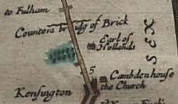
The upper reaches have been variously known as Billingswell Ditch, Pools Creek and Counters Creek. In the Middle Ages, the creek was known as Billingwell Dyche, derived from 'Billing's spring or stream'. It formed the boundary between the parishes of Kensington and Fulham. By the eighteenth century, the creek had become known as Counter's Creek, which is believed to derive from 'Counter's Bridge' which crossed the creek at the west end of Kensington High Street. This was first recorded in the fourteenth century as 'Countessesbrugge', and may be called after Matilda/Maud, Countess of Oxford, who in early centuries after the Conquest held the manor of Kensington. [7] [8] Stamford Bridge is considered to be a corruption of 'Samfordesbrigge' meaning 'the bridge at the sandy ford' where the Fulham Road crosses the brook. [9] The existing Stamford Bridge was built of brick in 1860–2 and has been partly reconstructed since then. The name is more generally used to refer to the nearby Stamford Bridge Stadium, which is the home of Chelsea Football Club. In 1824–8 the lowest part of the creek was developed into the Kensington Canal. This was taken over by the Bristol Birmingham & Thames Junction Railway in the 1830s and subsequently much was culverted to take the West London Line along its course in 1859–63. [10] This railway route links Clapham Junction to Willesden Junction via Kensington Olympia. Only the lower reach remained in use, supplying coal to Sands End gas works and later to Lots Road Power Station. [5] The stream was visible as a surface river on the west side of Little Wormwood Scrubs on Ordnance Survey maps pre-1930 by which time surface water drains had been introduced, some of which fed the sewer, others which conveyed surface water separately.

Its depression has been conveniently used since the 19th century and rise of the water closet for the sanitation of the area by building a combined sewer underneath it and to prevent flooding, to construct where the Metropolitan Board of Works and London Boroughs have found affordable, separate surface water drains leading to the Thames. [11]

...necessity arose for making a sewer to intercept the sewage of the district west of Cremorne [Chelsea], and to help it on its way to Barking. But there was no good thoroughfare from Cremorne eastwards along which to construct it; so it was proposed to form a route for the sewer, and at the same time to complete an unfinished work by continuing the embankment and road on to Battersea. Application was made to Government for the return of £38,150, a sum which remained unexpended from the amount originally raised for the bridge and embankment, and which would have assisted in the prosecution of the new work. The application, however, was unsuccessful, and Sir William Tite, who from the first took a very active interest in the matter, appealed to the Metropolitan Board of Works to undertake the work independently of Government assistance. The Board, therefore, made several applications to Parliament for an Act, which they succeeded in obtaining in 1868. The designs for the embankment, roadway, and sewer were at once prepared by [Sir Joseph] Bazalgette, the engineer to the Board, and the whole work was completed and opened to the public in 1874. [11]

See also

Related Research Articles

<span class="mw-page-title-main">Fulham</span> Area of west London, England

Fulham is an area of the London Borough of Hammersmith & Fulham in West London, England, 3.6 miles (5.8 km) southwest of Charing Cross. It lies on the north bank of the River Thames, bordering Hammersmith, Kensington and Chelsea. The area faces Wandsworth, Putney, Barn Elms and the London Wetland Centre in Barnes. on the far side of the river.

<span class="mw-page-title-main">Chelsea, London</span> District in west London, England

Chelsea is an affluent area in West London, England, due south-west of Charing Cross by approximately 2.5 miles. It lies on the north bank of the River Thames and for postal purposes is part of the south-western postal area.

Sands End is an area of the ancient parish of Fulham, formerly in the County of Middlesex, which is now the southernmost part of the London Borough of Hammersmith and Fulham, England. In a deep loop of the River Thames, between the tidal Chelsea Creek and the old Peterborough estate, west of Wandsworth Bridge, its northern edge is New King's Road. While wharves, industrial acres and workers' cottages gave way to intensive re-development such as Chelsea Harbour and Imperial Wharf in the last quarter of the 20th-century, it still contains some 300-year-old cottages and 19th century streets.

<span class="mw-page-title-main">Northern Outfall Sewer</span> Sewer in London

The Northern Outfall Sewer (NOS) is a major gravity sewer which runs from Wick Lane in Hackney to the Beckton Sewage Treatment Works in east London. Most of it was designed by Joseph Bazalgette, as a result of an outbreak of cholera in 1853 and the "Great Stink" of 1858.

<span class="mw-page-title-main">Lots Road Power Station</span> Disused power station in Chelsea, London

Lots Road Power Station is a disused coal and later oil-fired and later gas-fired power station on the River Thames at Lots Road in Chelsea, London in the south-west of the Royal Borough of Kensington & Chelsea, which supplied electricity to the London Underground system. It is sometimes erroneously referred to as Fulham Power Station, a name properly applied to another former station a mile south-west along the Tideway.

<span class="mw-page-title-main">Stamford Brook</span> Subterranean river in London, England

Stamford Brook was a tributary of the Tideway stretch of the River Thames in west London supplied by three headwaters. Historically used as an irrigation ditch or dyke, the network of small watercourses had four lower courses and mouths.

<span class="mw-page-title-main">Little Wormwood Scrubs</span>

Little Wormwood Scrubs is a park in Kensal Green on the border of Hammersmith and Fulham and Royal Borough of Kensington and Chelsea. Counter's Creek, a now subterranean stream that arises in Kensal Green flows south through the park, eventually joining the River Thames.

The Royal Borough of Kensington and Chelsea, an Inner London borough, has responsibility for some of the parks and open spaces within its boundaries. Most of them are relatively small: many are the typical London square, built to service the houses around that square. Two of the larger open spaces both form part of the "Magnificent Seven" cemeteries, being those at Brompton and Kensal Green. The parks are policed by the Royal Borough of Kensington and Chelsea Parks Police.

<span class="mw-page-title-main">Parks and open spaces in the London Borough of Hammersmith and Fulham</span>

The London Borough of Hammersmith & Fulham, an Inner London borough, has 231 hectares of parks and open spaces that are accessible to the general public, 159 hectares being within parks and 52.5 hectares within cemeteries and churchyards. Wormwood Scrubs and Scrubs Wood, located in the north of the Borough account for 42 hectares and Fulham Palace and Bishop's Park grounds contain another 14 hectares of open space. Private open space includes Hurlingham, Fulham and Queen's Club in West Kensington.

West Kensington, formerly North End, is an area in the ancient parish of Fulham, in the London Borough of Hammersmith and Fulham, England, 3.4 miles (5.5 km) west of Charing Cross. It covers most of the London postal area of W14, including the area around Barons Court tube station, and is defined as the area between Lillie Road and Hammersmith Road to the west, Fulham Palace Road to the south, Hammersmith to the north and West Brompton and Earl's Court to the east. The area is bisected by the major London artery the A4, locally known as the Talgarth Road. Its main local thoroughfare is the North End Road.

<span class="mw-page-title-main">Fulham Road</span> Street in London, England

Fulham Road is a street in London, England, which comprises the A304 and part of the A308.

Brompton, sometimes called Old Brompton, survives in name as a ward in the Royal Borough of Kensington and Chelsea in London. Until the latter half of the 19th century it was a scattered village made up mostly of market gardens in the county of Middlesex. It lay south-east of the village of Kensington, abutting the parish of St Margaret's, Westminster at the hamlet of Knightsbridge to the north-east, with Little Chelsea to the south. It was bisected by the Fulham Turnpike, the main road westward out of London to the ancient parish of Fulham and on to Putney and Surrey. It saw its first parish church, Holy Trinity Brompton, only in 1829. Today the village has been comprehensively eclipsed by segmentation due principally to railway development culminating in London Underground lines, and its imposition of station names, including Knightsbridge, South Kensington and Gloucester Road as the names of stops during accelerated urbanisation, but lacking any cogent reference to local history and usage or distinctions from neighbouring settlements.

<span class="mw-page-title-main">Tideway</span> Part of the River Thames subject to tides

The Tideway is a part of the River Thames in England which is subject to tides. This stretch of water is downstream from Teddington Lock. The Tideway comprises the upper Thames Estuary including the Pool of London.

<span class="mw-page-title-main">West Brompton</span> Human settlement in England

West Brompton is an area of west London, England, that straddles the boundary between the London Borough of Hammersmith and Fulham and Royal Borough of Kensington and Chelsea. The centuries-old boundary was traced by Counter's Creek, now lost beneath the West London Line railway.

<span class="mw-page-title-main">Chelsea Harbour</span> Human settlement in England

Chelsea Harbour is a contemporary mixed-use development in West London, situated in its Sands End area, along Chelsea Creek, the historic southeastern boundary of the London Borough of Hammersmith and Fulham with the southwestern boundary of the Royal Borough of Kensington and Chelsea, and opposite the site of the old Lots Road Power Station in Chelsea. The development consists of luxury apartments, the Chelsea Harbour Marina and the Chelsea Harbour Design Centre and a hotel, 'the Chelsea Harbour Hotel'.

<span class="mw-page-title-main">A3220 road</span> Road in west London

The A3220 is a primary A road in London, England. It runs north from Clapham Common to the A40 Westway at Ladbroke Grove.

<span class="mw-page-title-main">Walham Green</span> Area located on the border of Fulham and Chelsea, south-west London

Walham Green is the historic name of an English village, now part of inner London, in the parish of Fulham in the County of Middlesex. It was located between the hamlet of North End to the north, and Parsons Green to the south. To the east it was bounded by Counter's Creek, the historical boundary with the parish of Chelsea, and to the south-east is Sands End.

<span class="mw-page-title-main">Kensington Canal</span>

The Kensington Canal was a canal, about two miles long, opened in 1828 in London from the River Thames on the parish boundary between Chelsea and Fulham, along the line of Counter's Creek, to a basin near Warwick Road in Kensington. It had one lock near the Kensington Basin and wharves on the Fulham side, south of Lillie bridge. It was not commercially successful, and was purchased by a railway company, which laid a line along the route of the canal on the Fulham side. A second railway line followed in the filled-in littoral of the canal, thus one became London Underground's Wimbledon branch and the other, the West London Line.

<span class="mw-page-title-main">Lillie Bridge (Fulham)</span> Bridge in England

Lillie Bridge is a road bridge that links Old Brompton Road in the Royal Borough of Kensington and Chelsea with Lillie Road in the London Borough of Hammersmith & Fulham. It crosses two railways: the West London Line on the London Overground and the Wimbledon branch of the London Underground at West Brompton station.

References

  1. Nicholas Barton The Lost Rivers of London 1962 ISBN   0-948667-15-X
  2. "Nicholas Barton's map from his book Lost London Rivers". Archived from the original on 28 July 2011. Retrieved 25 November 2012.
  3. Map created by Ordnance Survey, courtesy of English Heritage Archived 24 April 2012 at the Wayback Machine
  4. "OpenStreetMap". OpenStreetMap.
  5. 1 2 "Stamford Bridge and the Billings area | British History Online". www.british-history.ac.uk.
  6. De Salis, HR (1969 reprint) Bradshaw's canals and navigable rivers of England and Wales: A reprint of a handbook of inland navigation for manufacturers, merchants, traders, and others, AM Kelley P436
  7. Edward Walford (1878). "The old court suburbs: Kensington". Old and New London: Volume 5. Institute of Historical Research. Retrieved 25 November 2012.
  8. J. E. B. Gover, Allen Mawer and F. M. Stenton, The Place-Names of Middlesex 1942
  9. Charles James Feret Fulham Old and New vol. ii, 1900
  10. The Kensington Canal, railways and related developments, Survey of London : volume 42: Kensington Square to Earl's Court (1986), pp. 322-338. Date accessed: 2 September 2008.
  11. 1 2 Edward Walford (1878). "Chelsea". Old and New London: Volume 5. Institute of Historical Research. Retrieved 25 November 2012.
Next confluence upstream River Thames Next confluence downstream
Falconbrook (south)Counter's Creek River Westbourne (north)

51°28′29″N0°10′49″W / 51.47472°N 0.18028°W / 51.47472; -0.18028