Jefferson is a census-designated place (CDP) in Jefferson Parish, Louisiana, United States, on the north side of the Mississippi River. Jefferson is part of the New Orleans–Metairie–Kenner metropolitan statistical area. The population was 11,193 at the 2010 census, and 10,533 in 2020. It is often known by locals as "Old Jefferson", but should not be confused with Old Jefferson in East Baton Rouge Parish, Louisiana.

Metairie is a census-designated place (CDP) in Jefferson Parish, Louisiana, United States, and is part of the New Orleans metropolitan area. With a population of 143,507 in 2020, Metairie is the largest community in Jefferson Parish and was the fifth-largest CDP in the United States. It is an unincorporated area that would have been Louisiana's fourth-largest city behind Shreveport if incorporated.

Westbury is a neighborhood in the Brays Oaks district of Southwest Houston, Texas, United States. It is located east of Bob White Road, north of U.S. Highway 90 Alternate, and west of South Post Oak Road, adjacent to the Fondren Southwest and Meyerland neighborhoods, just west of the southwest corner of the 610 Loop.
The Millionaires' Mile, Millionaires' Row, Billionaires Row, Golden Mile or Alpha Street are the exclusive residential neighborhoods of various cities, often along one scenic strip such as a riverside or hilltop drive, or a wide city boulevard.

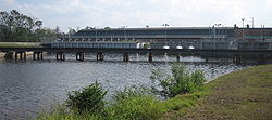
The 17th Street Canal is the largest and most important drainage canal in the city of New Orleans. Operating with Pump Station 6, it moves water into Lake Pontchartrain. The canal, along with the Orleans Canal and the London Avenue Canal, form the New Orleans Outfall Canals. The 17th Street Canal forms a significant portion of the boundary between the city of New Orleans and Metairie, Louisiana. The canal has also been known as the Metairie Outlet Canal and the Upperline Canal.
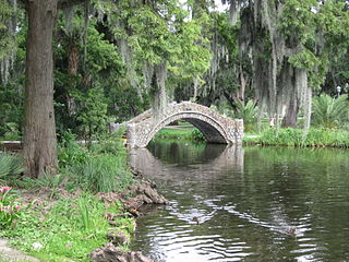
City Park, a 1,300-acre (5.3 km2) public park in New Orleans, Louisiana, is the 87th largest and 20th-most-visited urban public park in the United States. City Park is approximately 50% larger than Central Park in New York City, the municipal park recognized by Americans nationwide as the archetypal urban greenspace. Although it is an urban park whose land is owned by the City of New Orleans, it is administered by the City Park Improvement Association, an arm of state government, not by the New Orleans Parks and Parkways Department. City Park is unusual in that it is a largely self-supporting public park, with most of its annual budget derived from self-generated revenue through user fees and donations. In the wake of the enormous damage inflicted upon the park due to Hurricane Katrina, the Louisiana Department of Culture, Recreation and Tourism began to partially subsidize the park's operations.

The 17th Ward is one of the 17 Wards of New Orleans, a section of the city of New Orleans, Louisiana. New Orleans Districts and Wards. The 17th Ward, along with the 16th, was formed when the City of New Orleans annexed City of Carrollton in 1870.

Navarre is a neighborhood of the city of New Orleans. A subdistrict of the Lakeview District Area, its boundaries as defined by the City Planning Commission are: I-610, Canal Boulevard and Florida Boulevard to the north, Orleans Avenue to the east, City Park Avenue to the south and the Pontchartrain Expressway and Pontchartrain Boulevard to the west.

Gentilly is a broad, predominantly middle-class and racially diverse section of New Orleans, Louisiana. The Gentilly neighborhood is bounded by Lake Pontchartrain to the north, France Road to the east, Bayou St. John to the west, and CSX Transportation railroad tracks to the south.

U.S. Highway 90 Business is a business route of U.S. Highway 90 located in and near New Orleans, Louisiana. It runs 14.25 miles (22.93 km) in a general east–west direction from US 90 in Avondale to a junction with Interstate 10 (I-10) and US 90 in the New Orleans Central Business District.

The Earhart Expressway, named for former New Orleans Commissioner of Public Utilities, Fred A. Earhart, is a state highway located in both Jefferson Parish and Orleans Parish, Louisiana. It is also designated as Louisiana Highway 3139, spanning a total of 5.2 miles (8.4 km). Although it is an odd-numbered highway and is bannered north/south, it travels in a more east-to-west direction.

Louisiana Highway 611 is a collection of three current and ten former state-maintained streets in Jefferson, Metairie, and New Orleans. All thirteen routes were established with the 1955 Louisiana Highway renumbering.

Louisiana Highway 49 (LA 49) is a state highway located in Jefferson Parish, Louisiana. It runs 3.93 miles (6.32 km) in a north–south direction along Williams Boulevard from U.S. Highway 61 (US 61) to an intersection with Joe Yenni Boulevard and 44th Street in Kenner.

Claiborne Avenue is a major thoroughfare in New Orleans, Louisiana. It runs the length of the city, about 9.5 miles (15.3 km), beginning at the Jefferson Parish line and ending at the St. Bernard Parish line; the street continues under different names in both directions. It is called South Claiborne Avenue upriver from Canal Street and North Claiborne Avenue from Canal to St. Bernard Parish.

Louisiana Highway 3046 is a state highway in Louisiana that serves Jefferson Parish. It spans 1.0 mile (1.6 km) in a south to north direction. It is known locally as Causeway Boulevard.

Lakewood is a neighborhood of the city of New Orleans. A subdistrict of the Lakeview District Area, its boundaries as defined by the City Planning Commission are: Veterans Memorial Boulevard to the north, Pontchartrain Boulevard and the Pontchartrain Expressway to the east, Last, Quince, Hamilton, Peach, Mistletoe, Dixon, Cherry and Palmetto Streets to the south and the 17th Street Canal to the west.
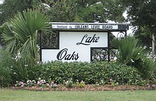
Lake Terrace/Lake Oaks is a neighborhood of the city of New Orleans, Louisiana. A sub-district of the city's Gentilly District, its boundaries as defined by the City Planning Commission are: Lake Pontchartrain to the north; the Industrial Canal to the east; Leon C. Simon Drive, Elysian Fields Avenue, New York Street, the London Avenue Canal, and Allen Toussaint Boulevard to the south; and Bayou St. John to the west. The neighborhood comprises the Lake Terrace and Lake Oaks subdivisions, the principal campus of the University of New Orleans, and the University of New Orleans Research & Technology Park — all built on land reclaimed from Lake Pontchartrain.

Louisiana Highway 613 was a collection of four state-maintained streets in Metairie and New Orleans established with the 1955 Louisiana Highway renumbering. All four routes have since been deleted from the state highway system.
Bayou Metairie was a stranded distributary bayou that was located in present-day New Orleans, Louisiana, USA, and Jefferson Parish, Louisiana, USA, that extended from the area known as River Ridge to Bayou St. John. Bayou Metairie was filled in during the late 19th century and early 20th century although remnants of Bayou Metairie persist.