17th Street Canal

Last updated

A woman walks her dog along the levee beside the flood wall on the Metairie side of the canal, November 11, 2005. In the background to the right, ongoing repairs in the breach on the New Orleans side can be seen. MetOutletCanalDogwalkerBreechBkgrd.jpg
A woman walks her dog along the levee beside the flood wall on the Metairie side of the canal, November 11, 2005. In the background to the right, ongoing repairs in the breach on the New Orleans side can be seen.

The 17th Street Canal is the largest and most important drainage canal in the city of New Orleans. Operating with Pump Station 6, it moves water into Lake Pontchartrain. The canal, along with the Orleans Canal and the London Avenue Canal, form the New Orleans Outfall Canals. The 17th Street Canal forms a significant portion of the boundary between the city of New Orleans and Metairie, Louisiana. The canal has also been known as the Metairie Outlet Canal and the Upperline Canal.

Contents

History

The canal that was to become later known as the 17th Street Canal seems to have had its origin at the start of the 1850s as a canal dug through swampy ground to raise a parallel right of way where the Jefferson and Lake Pontchartrain Railway was built. The railway, in business from 1853 through 1864, connected the town of Carrollton, Louisiana (along the Mississippi River front) with a shipping port on Lake Pontchartrain at what became Bucktown, Louisiana, a distance of about 8 km (5.0 mi). At the time, most of the land between the two terminals was undeveloped swamp.

Meanwhile, in 1858, a secondary canal was built to aid in drainage in the low swampy area in "back of town" from Carrollton, with its head at what is now the intersection of Dublin and Palmetto streets, connecting to the Railway canal a short distance on the river side of the Metairie Ridge.

The railway was discontinued on December 31, 1864, as competing rail lines between the river and lake were more successful. The city of New Orleans annexed Carrollton, and the canal became the boundary line between Orleans Parish and Jefferson Parish. As the canal marked the up-river limit of Orleans Parish, it became known as the Upperline Canal.

The spur canal in the back of Carrollton was beside a projected street numbered "17th Street" (although at the time there was little actual development in back of Claiborne Avenue), and that canal was thus the first to be known as the "17th Street Canal", a name which would later come to commonly refer to the large canal which this is connected to.

Improved drainage with pumping stations

"Pumping Station 6" astride the Canal from the back (lake) side MetariePump6Back.jpg
"Pumping Station 6" astride the Canal from the back (lake) side

By the 1870s, a steam engine powered pump known as the "Dublin Street Machine" at the back of the Carrollton neighborhood was used to drain that neighborhood, pumping the water out the Upperline Canal. Use of the canal to pump water from the streets of the city into Lake Pontchartrain grew with the city. The Claiborne Canal connected with the 17th and Upperline Canal system via a canal along Dublin Avenue; thus the canal served to carry rain water to the lake from the majority of Uptown New Orleans above the New Basin Canal. Another canal, Hoey's Canal, was added connecting to the Upperline from up river to help drain the back of the Jefferson Parish communities along the riverfront, now known as "Old Jefferson".

In 1894, "17th Street" was renamed "Palmetto Street" (later redesignated Palmetto Avenue), but the canal continued to be popularly known by the old street name.

In 1899 a new pumping station was opened atop the Canal a couple blocks back from Metairie Road. In the early 20th century, new high-efficiency pumps designed by A. Baldwin Wood were installed, and remain in operation.

At the start of the 21st century, Pumping Station 6, or the Metairie Pumping Station, astride the canal had 15 pumps capable of moving over six billion gallons of water a day through the station. Runoff from substantial areas of Uptown New Orleans, Metairie, and surrounding neighborhoods drains into the canals and basins on the river side of the pumping station, which pulls the water up into the portion of the 17th Street Canal flowing into Lake Pontchartrain.

20th century: Residential development of the "Back of Town"

When the Station 6 was constructed, it was at the "back" end of the developed part of town. As the area alongside the canal closer to the lake was largely undeveloped swamp, it was originally of little concern if waters pumped out of the city topped the canal and flowed into the swamp during heavy rains.

A portion of the 17th Street Canal, looking lakeward from behind the Metairie Road Pumping Station. Note the levees topped with concrete flood walls. 17StCanalLakewardFromMetarieRd.jpg
A portion of the 17th Street Canal, looking lakeward from behind the Metairie Road Pumping Station. Note the levees topped with concrete flood walls.

In the late 1920s and the 1930s, a project dredged fill along the lakefront, creating new land in what had been Lake Pontchartrain and creating a sizable levee along the lake side. However, no efforts were made to raise the swampland between Metairie Ridge and the new lakefront fill. The areas along the Canal from Metairie Ridge to the Lake were substantially developed for residential use after World War II, and levees along the "back" sections of the Canal were raised. The water level of the canal is often significantly higher than the surrounding streets.

After Hurricane Betsy, improved flood protection for the city and its canals to cope with storm surge from hurricanes was mandated, resulting in increasing the size and height of the canal levees. In 1998 Hurricane Georges elevated the level of Lake Pontchartrain, pushing lake waters into the canal. A report noted that there was at least one place where the water came within inches of topping the flood wall. An upgrade of the canal levees, flood walls, and bridges began in 1999. The canal was considered in good shape at the start of the 2005 Atlantic Hurricane Season.

Before Katrina arrived, the 17th Street Canal was the largest and most important drainage canal in the city of New Orleans. Operating with Pumping Station No. 6 – which at that time was the most powerful pumping station in the world – the 17th Street Canal was capable of conveying 9,200 cubic feet per second (cfs) of water, more than the Orleans Avenue and London Avenue Canals combined. (The Orleans Avenue Canal, at maximum capacity, could pump 2,200 cfs and the London Avenue Canal, at maximum capacity, could pump 5,200 cfs.) [1]

Hurricane Katrina

Water is pumped out of the Lakeview neighborhood of New Orleans into the 17th Street Canal. 17th Street Canal, in New Orleans.jpg
Water is pumped out of the Lakeview neighborhood of New Orleans into the 17th Street Canal.

At about 6:30 am on August 29, 2005, a portion of the I-wall along the east side of the 17th Street Canal adjacent to the 6900 block of Bellaire Drive split open, sending torrents of water into New Orleans' Lakeview neighborhood. The water level in the Canal at the time of failure was about 5 feet lower than the top of the I-wall, well below the design water level. The breach released storm-surge floodwaters that destroyed buildings, homes, and infrastructure, throughout all but the highest areas within the city. The initial breach expanded to a nearly 450-foot wide gap. Thirty-one (31) victims were recovered from areas directly flooded due to the breach of the 17th Street Canal levee. [2]

Investigations into the breach

Two teams investigated the failure, the Interagency Performance Evaluation Task Force (IPET) and the Independent Levee Investigation Team (ILIT). The studies confirmed that the canal flood wall failed at significantly lower water level than the top of the flood wall due to faulty design. In August 2007, the Corps announced the results of an engineering analysis applying more stringent post-Katrina design criteria which showed the maximum safe load on some of the surviving flood walls is only 7 feet (2.1 m) of water, which is half the original 14-foot (4.3 m) design intent. [3]

On November 10, 2005, an article in the Times-Picayune revealed that sonar soundings discovered that the steel sheet pilings of the levee flood wall were 2.1 m (7 ft) less deep than engineering specifications. Sample pilings pulled up were found to be of the length specified in the design (17 feet), but it was then revealed that this length was less than the actual depth of the canal, in retrospect an obvious engineering mistake. Current analysis concludes that the catastrophic breach was due to faulty design, rather than storm surge higher than what the canal was designed to withstand. According to an article published in the August 2015 issue of the official journal of the World Water Council, the Army Corps of Engineers misinterpreted the results of a Sheet Pile Load test (E-99 Study) conducted in the mid-1980s and concluded they needed to drive sheet pilings to depths of not more than 17 feet, rather than the necessary 31 to 46 feet. This move saved millions but greatly reduced overall engineering reliability. [4]

Reconstruction after Katrina

Louisiana State Historic Plaque at the site of the 17th Street Canal levee breach. Vetted and fact checked by the Louisiana Office of Historic Preservation. Historic Plaque-17th Street Canal Levee Breach.jpg
Louisiana State Historic Plaque at the site of the 17th Street Canal levee breach. Vetted and fact checked by the Louisiana Office of Historic Preservation.

The Corps constructed a permanent auxiliary pump station.[ citation needed ] During a hurricane event, the gate will be closed and its pump station will operate in tandem with local Pump Station 6 to act as a barrier to storm surge and lake flooding. In January 2006, the U.S. Army Corps of Engineers announced it had finished the temporary repairs of the breached section of the levee, and construction of more permanent repairs would commence. As a temporary measure, the corps constructed storm-surge barrier gates and an interim pump station at the lake end of the canal. In February 2007, a contract was awarded to WESTON Solutions to increase the pumping capacity of the 17th Street Canal. [5]

In June 2008, plans were announced by the Corps of Engineers to clear private land for access to the flood wall and levee. This land comprises the backyards along Bellaire Drive on the New Orleans (east) side of the canal. On July 7, 2008, a state court judge ruled the Corps could continue, but that property owners could seek compensation. [6] Plans to clear encroachments on the west (Jefferson Parish) side of the canal were to begin with field surveys in early 2009.

A whistle blower claimed the temporary pumps have inadequate capacity to prevent the canal from overflowing and predicted failure of both the pumps and gates. [7] But on September 1, 2008, the gates were closed as Hurricane Gustav approached the Louisiana coast. Both hydraulic and direct drive pumps were operated without problem for several hours during the peak storm surge. The gates remained closed for 18 hours and pumps were operated over a 9-hour period to keep the city from flooding. [8]

In August 2010, the grassroots group Levees.org installed a plaque, vetted and fact checked by the Louisiana State Office of Historic Preservation, at the levee breach site. The text of the plaque reads as follows:

On August 29, 2005, a federal floodwall atop a levee on the 17th Street Canal, the largest and most important drainage canal for the city, gave way here causing flooding that killed hundreds. This breach was one of 50 ruptures in the federal Flood Protection System that occurred that day. In 2008, the US District Court placed responsibility for this floodwall's collapse squarely on the US Army Corps of Engineers; however, the agency is protected from financial liability in the Flood Control Act of 1928.

In 2017, seventeen Patterson pumps are set to be operational as part of the New Orleans Permanent Canal Closures and Pumps (PCCP) project with the 17 Street Canal receiving six large capacity and two smaller pumps. The large pumps are rated at 1,800 cfs and are the centerpiece of the project which is designed to handle a 100-year storm. [9]

See also

Related Research Articles

<span class="mw-page-title-main">Lake Pontchartrain</span> Estuary located in southeastern Louisiana, United States

Lake Pontchartrain is an estuary located in southeastern Louisiana in the United States. It covers an area of 630 square miles (1,600 km2) with an average depth of 12 to 14 feet. Some shipping channels are kept deeper through dredging. It is roughly oval in shape, about 40 miles (64 km) from west to east and 24 miles (39 km) from south to north.

<span class="mw-page-title-main">Effects of Hurricane Katrina in New Orleans</span>

As the center of Hurricane Katrina passed southeast of New Orleans on August 29, 2005, winds downtown were in the Category 1 range with frequent intense gusts. The storm surge caused approximately 23 breaches in the drainage canal and navigational canal levees and flood walls. As mandated in the Flood Control Act of 1965, responsibility for the design and construction of the city's levees belongs to the United States Army Corps of Engineers and responsibility for their maintenance belongs to the Orleans Levee Board. The failures of levees and flood walls during Katrina are considered by experts to be the worst engineering disaster in the history of the United States. By August 31, 2005, 80% of New Orleans was flooded, with some parts under 15 feet (4.6 m) of water. The famous French Quarter and Garden District escaped flooding because those areas are above sea level. The major breaches included the 17th Street Canal levee, the Industrial Canal levee, and the London Avenue Canal flood wall. These breaches caused the majority of the flooding, according to a June 2007 report by the American Society of Civil Engineers. The flood disaster halted oil production and refining which increased oil prices worldwide.

<span class="mw-page-title-main">Hurricane preparedness in New Orleans</span>

Hurricane preparedness in New Orleans has been an issue since the city's early settlement because of its location.

From 1890 through 2006, the Orleans Levee Board (OLB) was the body of commissioners that oversaw the Orleans Levee District (OLD) which supervised the levee and floodwall system in Orleans Parish, Louisiana The role of the OLB has changed over time. Prior to Hurricane Betsy in 1965, the OLB developed land and sold it to raise money to build and improve flood protection levees. After Betsy, Congress passed the Flood Control Act of 1965 which directed the Army Corps of Engineers to design and build the hurricane flood protection system enveloping New Orleans. Owing to the 1965 legislation, the OLB's duties were now limited to collecting the 30% cost share for project design and construction, and to maintaining and operating completed flood protection structures.

The Southeast Louisiana Urban Flood Control Project is a flood control project by the US Army Corps of Engineers to protect the New Orleans district from flooding due to potential storms, hurricanes, or water surges. It was established in 1996.

The Pontchartrain Expressway is a parallel six-lane section of Interstate 10 (I-10) and U.S. Route 90 Business in New Orleans, Louisiana, USA, with a brief stand-alone section in between junctions with these highways. The designation begins on I-10 near the Orleans–Jefferson parish line at the I-610 Split. The expressway follows I-10 into the Central Business District (CBD) of New Orleans and then follows US 90 Bus. to the Crescent City Connection. The expressway takes its name from Pontchartrain Boulevard, which the expressway replaced in some areas. The Pontchartrain name is derived from Lake Pontchartrain, which New Orleans' northern border traverses.

<span class="mw-page-title-main">Industrial Canal</span> Canal in Louisiana, United States of America

The Industrial Canal is a 5.5 mile (9 km) waterway in New Orleans, Louisiana, United States. The waterway's proper name, as used by the U.S. Army Corps of Engineers and on NOAA nautical charts, is Inner Harbor Navigation Canal (IHNC). The more common "Industrial Canal" name is used locally, both by commercial mariners and by landside residents.

<span class="mw-page-title-main">London Avenue Canal</span>

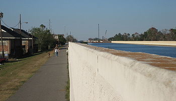
The London Avenue Canal is a drainage canal in New Orleans, Louisiana, used for pumping rain water into Lake Pontchartrain. The canal runs through the 7th Ward of New Orleans from the Gentilly area to the Lakefront. It is one of the three main drainage canals responsible for draining rainwater from the main basin of New Orleans. The London Avenue Canal's flood walls built atop earthen levees breached on both sides during Hurricane Katrina in 2005.

<span class="mw-page-title-main">Civil engineering and infrastructure repair in New Orleans after Hurricane Katrina</span> Overview of civil engineering and infrastructure repair post Hurricane Katerina

Though Hurricane Katrina did not deal the city of New Orleans a direct hit on August 29, 2005, the associated storm surge precipitated catastrophic failures of the levees and flood walls. The Mississippi River Gulf Outlet ("MR-GO") breached its levees in approximately 15 places. The major levee breaches in the city include the 17th Street Canal levee, the London Avenue Canal, and the wide, navigable Industrial Canal, which left approximately 80% of the city flooded.

On Monday, August 29, 2005, there were over 50 failures of the levees and flood walls protecting New Orleans, Louisiana, and its suburbs following passage of Hurricane Katrina. The failures caused flooding in 80% of New Orleans and all of St. Bernard Parish. In New Orleans alone, 134,000 housing units — 70% of all occupied units — suffered damage from Hurricane Katrina and the subsequent flooding.

Drainage in New Orleans, Louisiana, has been a major concern since the founding of the city in the early 18th century, remaining an important factor in the history of New Orleans today. The central portion of metropolitan New Orleans is fairly unusual in that it is almost completely surrounded by water: Lake Pontchartrain to the north, Lake Borgne to the east, wetlands to the east and west, and the Mississippi River to the south. Half of the land area between these bodies of water is at or below sea level, and no longer has a natural outlet for flowing surface water. As such, virtually all rainfall occurring within this area must be removed through either evapotranspiration or pumping. Thus, flood threats to metropolitan New Orleans include the Mississippi River, Lake Pontchartrain, canals throughout the city, and natural rainfall. Artificial levees have been built to keep out rising river and lake waters but have had the negative effect of keeping rainfall in, and have failed on numerous occasions.

<span class="mw-page-title-main">Orleans Canal</span>

The Orleans Canal is a drainage canal in New Orleans, Louisiana. The canal, along with the 17th Street Canal and the London Avenue Canal, form the New Orleans Outfall Canals. The current version of the canal is about 2 km long, running along the up-river side of City Park, through the Lakeview and Lakeshore neighborhood, and into Lake Pontchartrain. It is part of the system used to pump rain water out of the streets of the city into the Lake. The Canal has also been known as the Orleans Avenue Canal, the Orleans Outfall Canal, the Orleans Tail Race, and early on, the Girod Canal.

<span class="mw-page-title-main">17th Ward of New Orleans</span>

The 17th Ward is one of the 17 Wards of New Orleans, a section of the city of New Orleans, Louisiana. New Orleans Districts and Wards. The 17th Ward, along with the 16th, was formed when the City of New Orleans annexed City of Carrollton in 1870.

<span class="mw-page-title-main">Lakeview, New Orleans</span> New Orleans Neighborhood in Louisiana, United States

Lakeview is a neighborhood of the city of New Orleans. A subdistrict of the Lakeview District Area, its boundaries as defined by the City Planning Commission are: Allen Toussaint Boulevard to the north, Orleans Avenue to the east, Florida Boulevard, Canal Boulevard and I-610 to the south and Pontchartrain Boulevard to the west. Lakeview is sometimes used to describe the entire area bounded by Lake Pontchartrain to the north, the Orleans Avenue Canal to the east, City Park Avenue to the south and the 17th Street Canal to the west. This larger definition includes the West End, Lakewood and Navarre neighborhoods, as well as the Lakefront neighborhoods of Lakeshore and Lake Vista.

<span class="mw-page-title-main">Sauvé's Crevasse</span>

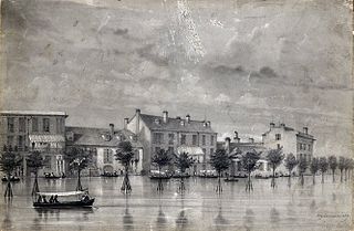
Sauvé's Crevasse was a Mississippi River levee failure in May 1849 that resulted in flooding much of New Orleans, Louisiana.

The Flood Control Act of 1965, Title II of Pub. L. 89–298, was enacted on October 27, 1965, by the 89th Congress and authorized the United States Army Corps of Engineers to design and construct numerous flood control projects including the Lake Pontchartrain and Vicinity, Louisiana Hurricane Protection Project in the New Orleans region of south Louisiana.

The United States Army Corps of Engineers is involved with a wide spectrum of public works projects: environmental protection, water supply, recreation, flood damage and reduction, beach nourishment, homeland security, military construction, and support to other Governmental agencies. Through 19 Flood Control Acts since 1917, Congress has authorized the Corps of Engineers to be involved with flood protection and damage reduction in almost every state of the union.

The United States Army Corps of Engineers is involved with a wide spectrum of public works projects: environmental protection, water supply, recreation, flood damage and reduction, beach nourishment, homeland security, military construction, and support to other Governmental agencies. In nineteen (19) different Flood Control Acts since 1917, the United States Congress has authorized the corps to design and build flood protection projects and one risk reduction system in the Greater New Orleans area and throughout the nation.

<span class="mw-page-title-main">Seabrook Floodgate</span> Bridge in New Orleans, Louisiana

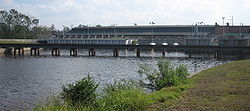
The Inner Harbor Navigation Canal (IHNC) Seabrook Floodgate Structure is a flood barrier in the Industrial Canal in New Orleans, Louisiana. The floodgate is designed to protect the Industrial Canal and the surrounding areas from a storm surge from Lake Pontchartrain. It consists of two 50-foot (15 m) wide vertical lift gates and a 95-foot (29 m) wide sector gate.

<span class="mw-page-title-main">New Orleans Outfall Canals</span>

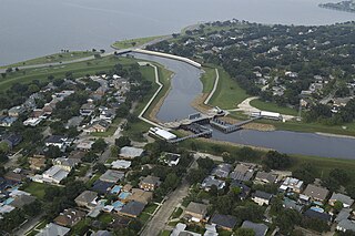
There are three outfall canals in New Orleans, Louisiana – the 17th Street, Orleans Avenue and London Avenue canals. These canals are a critical element of New Orleans’ flood control system, serving as drainage conduits for much of the city. There are 13 miles (21 km) of levees and floodwalls that line the sides of the canals. The 17th Street Canal is the largest and most important drainage canal and is capable of conveying more water than the Orleans Avenue and London Avenue Canals combined.

References

  1. J. David Rogers, G. Paul Kemp (2015). "Interaction between the US Army Corps of Engineers and the Orleans Levee Board preceding the drainage canal wall failures and catastrophic flooding of New Orleans in 2005". Water Policy: 712. Retrieved January 27, 2017.
  2. Ezra C. Boyd (2012). "Estimating and Mapping the Direct Flood Fatality Rate for Flooding in Greater New Orleans Due To Hurricane Katrina". Risk, Hazards & Crisis in Public Policy: 91. doi:10.2202/1944-4079.1017.
  3. Grissett, Sheila (August 5, 2007). "Corps analysis shows canal's weaknesses". The Times-Picayune. Archived from the original on July 28, 2013. Retrieved November 28, 2015.
  4. J. David Rogers, G. Paul Kemp (2015). "Interaction between the US Army Corps of Engineers and the Orleans Levee Board preceding the drainage canal wall failures and catastrophic flooding of New Orleans in 2005". Water Policy: 707. Retrieved October 31, 2015.
  5. "WESTON Awarded $85 Million Contract to Expand Temporary Pumping Capacity at 17th Street and London Avenue Canals in New Orleans, LA" (Press release). Weston Solutions. Archived from the original on June 29, 2007.
  6. Vargas, Ramon Antonio (July 7, 2008). "Corps to begin removing trees, fences along 17th Street Canal". The Times-Picayune. Retrieved November 28, 2015.
  7. Garzino, Maria (February 5, 2011). "Whistleblower Maria E. Garzino's Letter to the President" (PDF). pogoarchives.org. Project on Government Oversight. Retrieved November 28, 2015.
  8. Spaht, Susan (September 19, 2008). "Hurricane Gustav priority repairs mostly complete" (PDF). www.mvn.usace.army.mil. U.S. Army Corps of Engineers Web Archive. Archived from the original (PDF) on February 26, 2013. Retrieved November 28, 2015.
  9. Hand, Aaron (March 6, 2015). "Process Automation Desk: 'Monster Pumps' Will Protect New Orleans from Flooding". Automation World. Retrieved November 6, 2015.

Further reading

30°00′41″N90°07′19″W / 30.01139°N 90.12194°W / 30.01139; -90.12194