Carrollton, New Orleans

Last updated

Carrollton Historic District
Carrollton sign.jpg
Sign on Carrollton Avenue near St. Charles Avenue
USA Louisiana location map.svg
Red pog.svg
Usa edcp location map.svg
Red pog.svg
LocationRoughly bounded by Lowerline St., Mississippi River, Monticello Ave., & Earhart Blvd., New Orleans, Louisiana
Coordinates 29°57′8″N90°7′38″W / 29.95222°N 90.12722°W / 29.95222; -90.12722 Coordinates: 29°57′8″N90°7′38″W / 29.95222°N 90.12722°W / 29.95222; -90.12722
Built1840
ArchitectMultiple
Architectural styleColonial Revival, Bungalow/Craftsman, Italianate
NRHP reference No. 87001893 [1]
Added to NRHPNovember 02, 1987

Carrollton is a historic neighborhood of Uptown New Orleans, Louisiana, USA, which includes the Carrollton Historic District, recognized by the Historic District Landmark Commission. [2] It is the part of Uptown New Orleans farthest upriver while still being easily accessible to the French Quarter. It was historically a separate town, laid out in 1833 and incorporated on March 10, 1845. [3] [4] Carrollton was annexed by New Orleans in 1874 (becoming the city's 16th and 17th Wards), but it has long retained some elements of distinct identity.

Contents

Historically the boundaries of the city of Carrollton were the Mississippi River, the downriver border of Jefferson Parish, Louisiana, Fig Street, and Lowerline Street. The area on the river side of Claiborne Avenue is sometimes referred to as "Old Carrollton". The incorporation of Carrollton created an apparent anomaly in New Orleans street names; Lowerline is upriver from Upperline Street, which was originally the upriver boundary of another suburb annexed in the 1850s.

City overview

Small businesses line Maple Street MapleStAp05.jpg
Small businesses line Maple Street

The main street is broad Carrollton Avenue, lined with Southern live oaks, with the St. Charles Avenue Streetcar running on the "neutral ground" or central median. The streetcar barn is a block off the avenue in Carrollton, on Willow Street, and the landmark Camellia Grill diner is near the corner of St. Charles and Carrollton Avenues. The neoclassical Carrollton Courthouse building is on Carrollton Avenue near the Mississippi; as of 2023, it houses The Carrollton, an upscale assisted living facility. [5]

The neighborhood and Avenue are pronounced "kaa-rull-ton" or "kaa-ril-tin" by residents and other uptowners, but many people from the downtown parts of New Orleans (especially those born in the mid-20th century and earlier) pronounce the names as "Karl-ton".

Tulane University and Loyola University New Orleans are just a few blocks below Carrollton, and many students, faculty, and staff live in the area and patronize the businesses there.

In addition to Carrollton Avenue and Saint Charles Avenue, the neighborhood still retains two "neighborhood main streets" of mixed residential and commercial use. Lower Carrollton centers on Maple Street, with many restaurants, coffee houses, bars, and upscale shops. Upper Carrollton has Oak Street, formerly hosting somewhat larger businesses (such as Woolworth); current businesses there range from restaurants and shops to the best known of the neighborhood's live music venues, the Maple Leaf Bar.

In the northwest section of Carrollton on Claiborne Avenue is Marsalis Harmony Park (formerly Palmer Park), which hosts some art festivals and moderate sized live music festivals each year. The park has a monument to the Carrolltonians who died in World War I. After Hurricane Katrina, then called Palmer Park, hosted the monthly Mid-City art market, displaced from the more severely damaged Mid-City neighborhood.

The historically predominantly African-American part of Carrollton along the riverfront has been known since the mid-20th century as "Black Pearl." Mahalia Jackson, the "Queen of Gospel music", was from the Black Pearl section of Carrollton.

This part of Carrollton is documented as the location of "Rising Sun Hall" near the riverfront in the late 19th century, which seems to have been a building owned and used for meetings of a Social Aid & Pleasure Club, commonly rented out for dances and functions. This is one possible inspiration for the legendary song "The House of the Rising Sun." Definite connections to gambling or prostitution, if any, are undocumented for either of these buildings, neither of which still exists.

Other smaller, sub-neighborhoods in the area are called Leonidas/Pigeontown, Riverbend, and East Carrollton.

Most of Carrollton has long been ethnically mixed, with "free people of color" owning homes in other parts of the town before the Civil War. Many immigrants from Germany, Ireland, and other parts of the United States settled here in the 19th century.

The post of "mayor of Carrollton" survived to the 1980s, although it was an informal one, representing the concerns of the neighborhood to the New Orleans city council. As of 2004, the United States Postal Service continues to deliver mail addressed to "Carrollton, Louisiana." The ZIP Code is 70118.

During New Orleans Mardi Gras celebrations, the Krewe of OAK parades through Carrollton. The Phunny Phorty Phellows krewe also holds its "parade" in Carrollton, throwing beads from the streetcar to usher in the parades season on what is colloquially known as Twelfth Night, the Epiphany, January 6.

Education

Primary and secondary schools

The Carrollton Courthouse as John McDonogh No. 23 Public School 719-South-Carrollton-New-Orleans.jpg
The Carrollton Courthouse as John McDonogh No. 23 Public School
The Nix Library Nix Library, Carrollton, New Orleans, 22 June 2022.jpg
The Nix Library

New Orleans Public Schools and the Recovery School District serve Carrollton.

Prominent in the area is the Carrollton Courthouse, the former courthouse for the city of Carrollton (located at 719 South Carrollton Avenue). Designed by prominent New Orleans architect Henry Howard, who also designed many other notable buildings around Louisiana including Nottoway Plantation and Madewood Plantation, [6] and completed in 1855, the site served as the courthouse for Carrollton and Jefferson Parish until the town was annexed onto New Orleans in 1874. [7] Since then, the building has housed McDonogh 23 elementary school, Ben Franklin Senior High School, Lusher Elementary School's 6-8 extension (now Lusher Charter School), and Audubon Charter School. [7] The building was vacant from 2013 until 2023, when The Carrollton, an upscale assisted living facility, was opened.

There was a private school named the Carrollton Private School, founded to avoid racial integration in the 1950s. The school campus was located on Willow Street at corner of Monroe Street. Grades 1 thru 8. [8]

In 2016 the board of Lycée Français de la Nouvelle-Orléans approved plans to ask to open a campus at the former James Weldon Johnson Elementary School in Carrollton. [9] The request was approved in March 2017. [10] That building temporarily housed Sophie B. Wright Charter School from 2013, [11] until 2016. [12]

Public libraries

The New Orleans Public Library operates the Nix Branch Library in Carrollton Riverbend. [13] Robert Morris of the Uptown Messenger said that it was a "popular little" library. [14] As of 2011 there was a "secret gardener" who watered the flowers on the library property. [13]

Related Research Articles

<span class="mw-page-title-main">Streetcars in New Orleans</span>

Streetcars in New Orleans have been an integral part of the city's public transportation network since the first half of the 19th century. The longest of New Orleans' streetcar lines, the St. Charles Avenue line, is the oldest continuously operating street railway system in the world. Today, the streetcars are operated by the New Orleans Regional Transit Authority (RTA).

<span class="mw-page-title-main">St. Charles Streetcar Line</span> Streetcar line in New Orleans, Louisiana

The St. Charles Streetcar Line is a historic streetcar line in New Orleans, Louisiana. Running since 1835, it is the oldest continuously operating streetcar line in the world. It is operated by the New Orleans Regional Transit Authority (RTA). Officially the St. Charles Streetcar line is designated as Route 12, and it runs along its namesake, St. Charles Avenue. It is the busiest route in the RTA system as it is heavily used by local commuters and tourists. On most RTA maps and publications, it is denoted in green, which is also the color of the streetcars on this line.

<span class="mw-page-title-main">New Orleans Public Library</span> Public library system in New Orleans, Louisiana

The New Orleans Public Library (NOPL) is the public library service of the city of New Orleans, Louisiana, United States.

<span class="mw-page-title-main">Broadmoor, New Orleans</span> New Orleans Neighborhood in Louisiana, United States

Broadmoor is a neighborhood of the city of New Orleans. A subdistrict of the Uptown/Carrollton Area, its boundaries as defined by the New Orleans City Planning Commission are: Eve Street to the north, Washington Avenue and Toledano Street to the east, South Claiborne Avenue to the south, and Jefferson Avenue, South Rocheblave Street, Nashville Avenue, and Octavia Street to the west. It includes the Broadmoor Historic District which was listed on the National Register of Historic Places in 2003 and increased in its boundaries in 2007.

<span class="mw-page-title-main">Uptown New Orleans</span> United States historic place

Uptown is a section of New Orleans, Louisiana, United States, on the east bank of the Mississippi River, encompassing a number of neighborhoods between the French Quarter and the Jefferson Parish line. It remains an area of mixed residential and small commercial properties, with a wealth of 19th-century architecture. It includes part or all of Uptown New Orleans Historic District, which is listed on the National Register of Historic Places.

<span class="mw-page-title-main">Central City, New Orleans</span> New Orleans Neighborhood in Louisiana, United States

Central City is a neighborhood of the city of New Orleans. It is located in the 11th Ward of New Orleans in Uptown, just above the Garden District, on the "lakeside" of St. Charles Avenue. A subdistrict of the Central City/Garden District Area, its boundaries as defined by the City Planning Commission are: MLK Boulevard, South Claiborne Avenue and the Pontchartrain Expressway to the north, Magazine, Thalia, Prytania and Felicity Streets and St. Charles Avenue to the south and Toledano Street, Louisiana Avenue and Washington Avenue to the west. This old predominantly African-American neighborhood has been important in the city's brass band and Mardi Gras Indian traditions.

<span class="mw-page-title-main">16th Ward of New Orleans</span>

The 16th Ward or Sixteenth Ward is a division of the city of New Orleans, Louisiana, one of the 17 Wards of New Orleans. It is an Uptown ward, along with the adjacent 17th Ward, formerly part of the city of Carrollton, Louisiana which was annexed by New Orleans in the 1870s.

<span class="mw-page-title-main">East Carrollton, New Orleans</span> Neighborhood in New Orleans, Louisiana, US

East Carrollton is a neighborhood of the city of New Orleans. A subdistrict of the Uptown/Carrollton Area, its boundaries as defined by the New Orleans City Planning Commission are: Spruce Street to the northeast, Lowerline Street to the southeast, St. Charles Avenue to the southwest and South Carrollton Avenue to the northwest.

<span class="mw-page-title-main">St. Charles Avenue</span> Thoroughfare in New Orleans, United States

St. Charles Avenue is a thoroughfare in New Orleans, Louisiana, U.S. and the route of the St. Charles Streetcar Line. It is also famous for the dozens of mansions that adorn the tree-lined boulevard for much of the uptown section of the boulevard. It is named for St. Charles Borromeo, patron saint of Charles III of Spain, the monarch when France transferred the then-vast territory of Louisiana to Spain at the conclusion of the Seven Years' War in 1763.

<span class="mw-page-title-main">Carrollton Avenue</span>

Carrollton Avenue is a major thoroughfare stretching 3.9 miles (6.3 km) across the Uptown/Carrollton and Mid-City districts of New Orleans. South Carrollton Avenue runs from St. Charles Avenue in the Riverbend in a northeast lake-bound direction through Carrollton and into Mid-City. After crossing Canal Street it continues as North Carrollton Avenue until intersecting with Esplanade Avenue and Wisner Boulevard at the entrance to City Park.

<span class="mw-page-title-main">Hollygrove, New Orleans</span> New Orleans Neighborhood in Louisiana, United States

Hollygrove is a neighborhood of the city of New Orleans, Louisiana, located in the city's 17th Ward. A subdistrict of the Uptown/Carrollton area, the boundaries as defined by the New Orleans City Planning Commission are the following: Palmetto Street to the north, Cambronne, Edinburgh, Forshey, Fig and Leonidas Streets to the east, Earhart Boulevard to the south and the Jefferson Parish boundary to the west. Conrad playground, the Cuccia-Byrnes playground and Larry Gilbert baseball stadium are located in Hollygrove. The Hollygrove Market and Farm is also located in Hollygrove. Particularly notable people, including rapper Lil Wayne, have grown up in the neighborhood.

<span class="mw-page-title-main">Lusher Charter School</span> Public charter school

Willow School, formerly Lusher Charter School, is a K-12 charter school in uptown New Orleans, Louisiana, in the university area. Lusher is chartered by Advocates for Arts Based Education (AABE), which acts as the board for the entire school. Lusher School has three uptown campuses; the K-5 program is housed at the Willow Street campus, the middle and high schools are both located at the Fortier campus on Freret Street, and a temporary campus was housed at the Jewish Community Center on St. Charles Avenue.

<span class="mw-page-title-main">Mid-City New Orleans</span> New Orleans neighborhood in Louisiana, United States

Mid-City is a neighborhood of the city of New Orleans. A sub-district of the Mid-City District Area, its boundaries as defined by the New Orleans City Planning Commission are: City Park Avenue, Toulouse Street, North Carrollton, Orleans Avenue, Bayou St. John and St. Louis Street to the north, North Broad Street to the east, and the Pontchartrain Expressway to the west. It is a historic district on the National Register of Historic Places. In common usage, a somewhat larger area surrounding these borders is often also referred to as part of Mid-City.

<span class="mw-page-title-main">Leonidas, New Orleans</span> New Orleans Neighborhood in Louisiana, United States

Leonidas is a neighborhood designation in the city of New Orleans. A subdistrict of the Uptown/Carrollton Area, its boundaries as defined by the New Orleans City Planning Commission are: South Claiborne Avenue, Leonidas and Fig Streets to the north, South Carrollton Avenue to the east, the Mississippi River and Jefferson Parish to the west. Although an official city planning district name, the name "Leonidas" is not widely used nor has it any historical usage and the area is usually referred to by the larger neighborhood "Uptown, or "Carrollton".

Pigeon Town is a New Orleans, Louisiana neighborhood located in the 17th Ward of New Orleans and within the larger Carrollton neighborhood, and within the area that the New Orleans city planning commission calls "Leonidas." Pigeon Town is (loosely) bordered by Cambronne St. (East), Claiborne Ave. (north), Oak St. (South) and the Orleans-Jefferson parish line on the west. It is situated directly between the Hollygrove neighborhood and the Oak Street Cultural Arts District.

<span class="mw-page-title-main">Carrollton Courthouse</span>

The Carrollton Courthouse is a historic building in the Carrollton neighborhood of New Orleans, Louisiana, in the United States. Built in 1855, it originally served as a courthouse before being utilized by several public schools. It is currently under construction for private-sector use.

<span class="mw-page-title-main">Lycée Français de la Nouvelle-Orléans</span>

Lycée Français de la Nouvelle-Orléans (LFNO) is a type II charter school, and French international school in New Orleans, Louisiana. As of 2021 it serves Pre-Kindergarten through grade 10 and will add a new grade level each school year until it is a full PK-12 school. It is under the Orleans Parish School Board (OPSB).

KIPP New Orleans Schools (KNOS) is the division of KIPP Schools active in the New Orleans metropolitan area.

<span class="mw-page-title-main">Freret Street</span> Street in Louisiana, United States

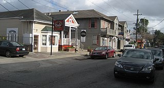
Freret Street is a street located in uptown New Orleans, Louisiana, United States, that extends from Leake Avenue to the Pontchartrain Expressway. Lying south of the neighborhood of Freret, Freret Street is known for its commercial corridor located between the street's intersection with Jefferson Avenue and Napoleon Avenue. It includes a wide range of restaurants, bars, and other entertainment venues.

References

Trivia

The rap duo $uicide Boy$ named a song on their album 'I Want To Die in New Orleans' after the neighborhood.

Notes

  1. "National Register Information System". National Register of Historic Places . National Park Service. April 15, 2008.
  2. "HDLC - City of New Orleans". www.nola.gov.
  3. Mary Ann Wegmann, Carrollton Courthouse: Stop 1 of 9 in the Carrollton Courthouse tour, New Orleans Historical (Midlo Center for New Orleans Studies, History Department, University of New Orleans & Communication Department, Tulane University, retrieved 3 Nov. 2017.
  4. The City of Carrollton at Media NOLA Archived November 7, 2017, at the Wayback Machine , a project of Tulane University, accessed 3 Nov. 2017.
  5. Riegel, Stephanie (February 15, 2023). "The Carrollton, a high-end senior living facility, opens in historic courthouse building". The Times-Picayune . Retrieved April 20, 2023.
  6. "Madewood History". Madewood.com. Retrieved March 19, 2013.
  7. 1 2 "NO Old Carrollton Courthouse". old-new-orleans.com. Retrieved March 19, 2013.
  8. Carl, p. 52.
  9. "Lycee Francais votes to request Johnson building in Carrollton as temporary space". Uptown Messenger . December 19, 2016. Retrieved May 26, 2020.
  10. Morris, Robert (March 13, 2017). "Lycee Francais approved for move to Johnson campus amid parents' misgivings". Uptown Messenger . Retrieved May 26, 2020.
  11. Morris, Robert (March 14, 2013). "Sophie B. Wright prepares for two-year exodus during school renovations and long-sought gym construction". Uptown Messenger . Retrieved May 27, 2020.
  12. Williams, Cedric (September 7, 2016). "Sophie B. Wright Charter returns triumphantly to original building". The Times Picayune . Archived from the original on September 8, 2016. Retrieved May 27, 2020.
  13. 1 2 Sisco, Annette. "Secret Gardener tends to Nix Library: Annette Sisco." The Times-Picayune . Thursday August 11, 2011. Retrieved on March 31, 2013.
  14. Morris, Robert (October 16, 2011). "With Nix library reopened, Carrollton neighbors plan to help beautify it". Uptown Messenger . Retrieved March 31, 2013.