New Orleans Regional Transit Authority

Last updated
New Orleans Regional Transit Authority
RTA New Orleans.png
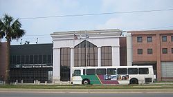
New Orleans RTA Building.jpg
RTA building on Canal Street
Founded1979
Headquarters New Orleans
Service areaCity of New Orleans
Orleans Parish, Louisiana
Service type Public transit
Heritage streetcar
Routes30 (bus)
5 (streetcar)
Stops2154 (bus)
286 (streetcar)
Annual ridership9,707,300 (2023)
Fuel typeDiesel (bus)
Electric (streetcar)
Operator Transdev (through 2020)
Chief executiveLona Edwards Hankins
Website www.norta.com
Streetcar network map New Orleans Streetcar Map.svg
Streetcar network map

The New Orleans Regional Transit Authority (RTA or NORTA) is a public transportation agency based in New Orleans. The agency was established by the Louisiana State Legislature in 1979, and has operated bus and historic streetcar service throughout the city since 1983, when it took over the city's mass transit system after nearly six decades' control by New Orleans Public Service, Inc. (now Entergy New Orleans). [1] In 2023, the system had a ridership of 9,707,300, or about 29,700 per weekday as of the third quarter of 2024, making the Regional Transit Authority the largest public transit agency in the state of Louisiana.

Contents

Basic rates for all modes, except ferries, are $1.25 per boarding (or $0.40 for 65 and up, disabled and Medicare, $0.50 for 5–17). 24-hour Jazzy Passes are $3, or $1 for youth and $0.80 for seniors, good for all modes including ferries. There are free transfer cards, good for next 120 minutes of unlimited use (round-trips/stopovers prohibited). Under 5 with a limit of three per paid rider can board for free. Transfers to ferries from busses/streetcars require paying difference in rates.

Hurricane Katrina

City buses were used before Hurricane Katrina hit to transport people to a refuge of last resort, of what's now the Caesars Superdome. Much of the city flooded due to the storm. The NORTA Administration building on Plaza Drive appears to have been in 10 feet (3.0 m) of water. Almost eighty-five percent of the fleet was rendered useless and inoperative; 146 city buses were visible outdoors in the flood at the 2817 Canal St. facility, while only 22 were at 3900 Desire Pky. The 8201 Willow St. facility was one block within the flood but was built above street level. The buses at the flooded facilities were mostly written off.

All but one of the streetcars built in the 1990s and 2000s were severely damaged in the flooding resulting from the hurricane. The historic Perley Thomas-built streetcars of the St. Charles line were undamaged in the disaster. The damaged streetcars, which had been built by hand on the property by local workers, were repaired in the same facility with components from Brookville Equipment Co. [2]

Post-disaster recovery

As of 2007, service had been restored to certain areas as they became habitable again. However, there was no 24-hour service on any bus or streetcar line, except for the St. Charles streetcar line. Streetcars were returned to the full length of Canal St. and the Riverfront, initially using the historic St. Charles Line streetcars, which had not been damaged, as had the red Canal cars. In 2008, the St. Charles streetcar resumed running the entire length of its route. By early 2009, the red Canal streetcars were repaired and had taken over service on the Canal and Riverfront Lines.

The buses that have been restored to operation have returned to several major thoroughfares, including Elysian Fields Avenue, Esplanade Avenue, Claiborne Avenue, St. Claude Avenue, Judge Perez Drive, General Meyer Avenue, Lapalco Boulevard, Robert E. Lee Boulevard, and the Chef Menteur Highway. And just a few express routes, Morrison Express, Lake Forest Express, Read-Crowder Express and Airport Express, serving both Eastern New Orleans, and New Orleans Louis Armstrong International Airport in Kenner, La. have been reinstated so far.

Service enhancements as of October 2, 2016: [3]

Operate the new N. Rampart/St. Claude Avenue streetcar from Elysian Fields to UPT via Rampart St. and Loyola Ave. Loyola/UPT line will no longer operate on Canal St. to the river, nor on Riverfront to the French Quarter stop.

Restore service to Canal Street on the 15-Freret and 28-MLK buses.

Increase service on the Canal and Riverfront streetcar lines.

Continue lines 57-Franklin and 88-St. Claude to Canal St. Operate 57-Franklin via Claiborne Ave. to increase service along N. Claiborne Ave. between Elysian Fields and St. Bernard Ave.

St. Charles Streetcar Tracks after Hurricane Katrina FEMA - 48805 - RTA Street Cars (Before).jpg
St. Charles Streetcar Tracks after Hurricane Katrina

Decrease travel times for riders from farther-out neighborhoods by operating Lines 88-St. Claude and 91-Jackson/Esplanade with fewer stops along Rampart to Canal.

Improve reliability of lines 5-Marigny/Bywater and 55-Elysian Fields with new schedules.

Provide earlier daily trips and later weekend trips on line 80-Desire/Louisa.

In September 2022, the New Orleans Regional Transit Authority announced that they would be almost entirely changing the lines, names, and wait times for the authority starting on September 25, 2022. [4] The changes were made after a survey was conducted containing 3,000 people saying that the old lines had been outdated, and were not convenient for everyday use. For 4 days after the new routes started, RTA offered free boarding on all buses, streetcars, and the Algiers Point Ferry. [5]

The changes were part of the New Links Network, a project designed to upgrade the transit authority to service the people of New Orleans. [6]

Upgrades from the previous lines include more access to jobs and landmarks, reduced wait times, longer service times, and faster transfers/connections. [7]

On July 18, 2022, the authority released Le Pass, a new trip planner and ticket app. It includes tickets and tracking for both RTA and Jefferson Transit buses. On August 29, 2022, RTA shut down ticket buying on the old RTA GoMobile app. [8] Le Pass updated from the old routes on September 25, 2022.

No changes were made to the streetcars or ferries.

Bus and streetcar routes

Streetcar on Canal Street, April 2007 CanalCemsKeepItCleanTram.jpg
Streetcar on Canal Street, April 2007

Current bus routes

In 2023, the NORTA bus system had a ridership of 5,596,500 [9] , or about 27,800 per weekday as of the third quarter of 2024. [10]


Route NameTerminal 1Terminal 2Lengthvianotes
3 Tulane - Elmwood Downtown
Saratoga + Tulane
Elmwood
Jefferson Hwy + Spur
10.2 miles (16.4 km)Tulane Avenue, South Carrollton Avenue, Jefferson Highway24-hour service (No evening or overnight service west of Jefferson + Causeway)
8 St Claude - ArabiDowntown
Main Library
Arabi
St Claude at Parish Line
5.4 miles (8.7 km)Rampart Street (Saint Claude Avenue)24-hour service
9 Broad - Napoleon Irish Channel
Napoleon + Tchoupitoulas
New Orleans East
New Orleans East Hub
14.0 miles (22.5 km)Napoleon Avenue, Broad Street, Chef Menteur Highway24-hour service
11 MagazineDowntown
Tulane + Loyola
West Riverside
Children's Hospital New Orleans
5.8 miles (9.3 km)Camp Street, Magazine Street
27 LouisianaSt. Thomas Dev
Rousseau + St Andrew
Navarre
Orleans + Navarre at Delgado Community College
7.9 miles (12.7 km)Tchoupitoulas Street, Louisiana Avenue, Toledano Street (Washington Avenue)
31 Leonidas - GentillyWest Riverside
Children's Hospital New Orleans
Gentilly Woods
Gentilly Woods Hub
12.4 miles (20.0 km)Leonidas Street, Carrollton Avenue, Gentilly Boulevard
32 Leonidas - TremeDowntown
Main Library
10.5 miles (16.9 km)Leonidas Street, Carrollton Avenue, Orleans Avenue
45 LakeviewNavarre
Cemeteries Transit Hub
7.5 miles (12.1 km)Canal Boulevard, Pontchartrain BoulevardOperates in a loop
51 St. Bernard - Claiborne St. Bernard
St. Bernard + Senate
Fontainebleau
Claiborne + Carollton
7.8 miles (12.6 km)Saint Bernard Avenue, Claiborne AvenueOvernight service on Claiborne Avenue provided by 53-O Paris - Claiborne Owl
52 Paris - Broadmoor Lake Terrace/Lake Oaks
University of New Orleans
Dixon
Palmetto + S. Carrollton at Xavier University
10.5 miles (16.9 km)Paris Avenue, Washington AvenueOvernight service on Paris Avenue provided by 53-O Paris-Claiborne Owl
53-O Paris-Claiborne OwlFontainebleau
Claiborne + Carrollton
Lake Terrace/Lake Oaks
University of New Orleans
10.9 miles (17.5 km)Claiborne Avenue, Paris AvenueRuns overnight service on portions of Routes 51 and 52
55 Elysian FieldsDowntown
Main Library
Gentilly Woods
Gentilly Woods Hub
11.0 miles (17.7 km)Elysian Fields Avenue, Press Drive (SB), Congress Drive (NB)24-hour service (No overnight service east of University of New Orleans)
57 Franklin - Freret Pontchartrain Park
Press + Emmett Bashful at SUNO
Audubon
Audubon Zoo
12.2 miles (19.6 km)Franklin Avenue, N Claiborne Avenue, Freret Street, Broadway
61 Lake Forest - Village De L'EstDowntown
Main Library
Village De L'Est
Chef Menteur + Old Gentilly at Gulfway Terrace Apartments
16.1 miles (25.9 km)I-10, Dwyer Road, Lake Forest Boulevard, Chef Menteur Highway24-hour service
62 Morrison - BullardNew Orleans East
New Orleans East Hub
13.3 miles (21.4 km)I-10, Morrison Road, Bullard RoadOvernight service provided by 62-O Morrison Owl
62-O Morrison Owl18.2 miles (29.3 km)I-10, Morrison Road, Bullard RoadRuns overnight service on portions of Routes 62 and 68
66 Hayne LoopNew Orleans East
New Orleans East Hub
17.1 miles (27.5 km)Leon C. Simon Drive, Hayne BoulevardOperates in a loop
67 Michoud Loop17.4 miles (28.0 km)Lake Forest Boulevard, Bullard Road, Old Gentilly Road, Michoud Boulevard
68 Little Woods Loop10.7 miles (17.2 km)Hayne Boulevard, I-10 Service Road
80 Desire - LouisaGentilly Woods
Gentilly Woods Hub
Marigny
Elysian Fields + Decatur
5.6 miles (9.0 km)Louisa Street, Desire Street
84 Galvez - Lower 9thDowntown
Main Library
Arabi
St Claude at Parish Line
8.1 miles (13.0 km)N Galvez Street, N Miro Street24-hour service
86 St. Maurice - ChalmetteArabi
St Claude at Jackson Barracks
Chalmette
Nunez Community College
13.5 miles (21.7 km)Tupelo Street, Judge Perez Drive, Paris Road, Fats Domino AvenueOperates in a loop
91 Jackson - EsplanadeSt. Thomas Dev
Rousseau + St. Andrew
Navarre
Cemeteries Transit Hub
8.0 miles (12.9 km)Jackson Avenue, Esplanade Avenue24-hour service
103 General Meyer LocalDowntown
Tulane + Loyola
New Aurora
General Meyer + Carver
14.3 miles (23.0 km)Pontchartrain Expressway, L.B. Landry Avenue, General Meyer Avenue24-hour service
105 Algiers Local Gretna
Wilty Terminal
Tall Timbers-Bretchel
Tullis + Woodland
7.9 miles (12.7 km)Holiday Drive, Tullis Drive
114A Garden Oaks - SullenDowntown
Tulane + Loyola
New Aurora
General Meyer + Carver
12.7 miles (20.4 km)Pontchartrain Expressway, General DeGaulle Drive, Sullen Drive24-hour service
114B Garden Oaks - WoodlandTall Timbers-Bretchel
Tullis + Woodland
12.7 miles (20.4 km)Pontchartrain Expressway, MacArthur Boulevard, Woodland Drive
202 Airport ExpressDowntown
Loyola + Tulane
Louis Armstrong International Airport 15.9 miles (25.6 km)I-10

List of streetcar routes [11]

In 2023, the streetcar system had a ridership of 3,884,800, or about 9,700 per weekday as of the third quarter of 2024 [9] .

No.RouteTerminal 1Terminal 2LengthNotes
2 Riverfront French MarketJohn Churchill Chase2 miles

(3.2 km)

Currently combined with Loyola section of 49 due to overhead line damage past Canal Street.
12 St. Charles Canal and Carondelet StreetsCarrolton and South Claiborne Avenue6 miles

(9.7 km)

24-hour service
46 Rampart-Loyola St. Claude and Elysian FieldsNew Orleans Union Passenger Terminal2.4 miles

(3.9 km)

Reopened May 19, 2024
47 Canal–Cemeteries Harrah's CasinoCemeteries Transit Hub3.6 miles

(5.8 km)

24-hour service
48 Canal–City Park/Museum City Park and Museum of Art3.6 miles

(5.8 km)

24-hour service
49 Loyola-Riverfront French MarketNew Orleans Union Passenger Terminal2.5 miles

(4.0 km)

Utilizes trackage from Rampart-Loyola, Canal, and Riverfront line.

Former routes

  • 1 Easy Rider Downtown Shuttle
  • 3 Vieux Carré
  • 5 Marigny-Bywater
  • 10 Tchoupitoulas
  • 13 St. Charles Shuttle
  • 14 Jackson
  • 15 Freret
  • 16 S Claiborne
  • 19 Nashville Express
  • 20 Nashville
  • 22 Broadway
  • 24 Napoleon
  • 28 M L King
  • 30 Airline
  • 34 Carrollton Express
  • 39 Tulane
  • 40 West End Express
  • 41 West End
  • 42 Canal – Cemeteries
  • 43 Canal Boulevard – Lake Vista
  • 44 Canal Boulevard Express – Lake Vista
  • 45 Canal – City Park
  • 46 Orleans (originally 46 City Park)
  • 48 Esplanade
  • 49 Lakeview
  • 50 St. Bernard – Senate
  • 51 St. Bernard – Lake Terrace
  • 52 St. Bernard – L. C. Simon
  • 53 Gentilly
  • 54 Mirabeau (originally 54 Cartier)
  • 56 Elysian Fields Express
  • 58 Franklin Express
  • 59 Congress
  • 60 Hayne
  • 63 New Orleans East Owl
  • 64 Lake Forest Express
  • 65 Six Flags Express (originally 65 Plaza Park-and-Ride)
  • 65 Read-Crowder Express
  • 66 Chef Menteur Highway Express
  • 67 Crowder
  • 69 New Orleans East Owl Loop
  • 70 Read – Hayne
  • 71 Read – Casino
  • 72 Paris Road Express
  • 73 Oak Island Loop
  • 80 Louisa
  • 81 Almonaster
  • 82 Desire
  • 83 Lower Ninth Ward
  • 85 Barracks
  • 88 St. Claude – Barracks
  • 89 St. Claude – Refinery
  • 90 Carrollton
  • 94 Broad
  • 96 Broad Rapid
  • 97 Broad – Oak Island
  • 98 Broad – Village de L'est
  • 99 Broad – NASA
  • 100 Algiers Owl
  • 101 Algiers Point
  • 102 General Meyer
  • 103 General Meyer/Pace
  • 104 Algiers Park-and-Ride
  • 105 Aurora
  • 106 Aurora Express
  • 106 Aurora Local
  • 107 General DeGaulle
  • 108 Algiers Local
  • 114 General DeGaulle-Sullen
  • 115 General DeGaulle-Tullis
  • 202 Kenner Park-and-Ride
  • 408 Algiers Local-L.B. Landry

Governance

The body in charge of making major decisions for the RTA is the Board of Commissioners. The board consists of appointees by the Mayor of New Orleans and of some appointees by the President of Jefferson Parish. The RTA Board has the overall authority for transit in New Orleans including setting fares, overseeing service and operations, developing operating budgets, approving each year's annual transportation development plan, and deciding upon capital purchases and expansions.

Under contract to the RTA Board of Commissioners, Transdev formerly managed all day-to-day aspects of the transit agency on behalf of the RTA Board. Transdev handled operations and service, safety issues, vehicle maintenance, customer care, route design and scheduling, human resources, administration, ridership growth, capital planning, grant administration, communications, purchasing, and other agency functions. Transdev was under contract to and reported to the RTA Board of Commissioners. The company operates public transportation for some 5,000 transit authorities around the world. Transdev (then Veolia Transport) was hired in 2008. [12]

As of December 20,2020, Transdev no longer manages the RTA. All bus, streetcar, and paratransit operators, and also maintenance personnel, are now employees of RTA. Ferry services continue to be operated for RTA by LabMar Ferry Services. [13]

See also

Related Research Articles

<span class="mw-page-title-main">Streetcars in New Orleans</span>

Streetcars have been an integral part of the public transportation network of New Orleans since the first half of the 19th century. The longest of the city's streetcar lines, the St. Charles Avenue line, is the oldest continuously operating street railway system in the world. Today, the streetcars are operated by the New Orleans Regional Transit Authority (RTA).

<span class="mw-page-title-main">Greater Cleveland Regional Transit Authority</span> Public transit agency for the city and suburbs of Cleveland, Ohio, USA

The Greater Cleveland Regional Transit Authority is the public transit agency for Cleveland, Ohio, United States and the surrounding suburbs of Cuyahoga County. RTA is the largest transit agency in Ohio, with a ridership of 22,431,500, or about 78,200 per weekday as of the third quarter of 2024.

<span class="mw-page-title-main">Canal Street, New Orleans</span> Street in New Orleans, Louisiana

Canal Street is a major thoroughfare in the city of New Orleans. Forming the upriver boundary of the city's oldest neighborhood, the French Quarter or Vieux Carré, it served historically as the dividing line between the colonial-era (18th-century) city and the newer American Sector, today's Central Business District.

<span class="mw-page-title-main">MBTA bus</span> Greater Boston bus network

The Massachusetts Bay Transportation Authority (MBTA) operates 152 bus routes in the Greater Boston area. The MBTA has a policy objective to provide transit service within walking distance for all residents living in areas with population densities greater than 5,000 inhabitants per square mile (1,900/km2) within the MBTA's service district. Much of this service is provided by bus. In 2023, the system had a ridership of 91,459,700, or about 322,600 per weekday as of the third quarter of 2024.

The Greater Dayton Regional Transit Authority, formerly known as the Miami Valley RTA, is a public transit agency that generally serves the greater Dayton, Ohio area. The GDRTA serves communities within Montgomery County and parts of Greene County, Ohio, USA. There are 18 routes. RTA operates diesel and electric trolley buses seven days a week, 21 hours a day, and provides services to many citizens within the area. RTA's current CEO is Bob Ruzinsky. In 2023, the system had a ridership of 6,570,600, or about 24,700 per weekday as of the third quarter of 2024.

<span class="mw-page-title-main">Fresno Area Express</span> Public transit agency of Fresno, California

Fresno Area Express (FAX) is a public transportation operator in Fresno, California. The system had over 100 buses, 1,606 bus stops, and 18 routes as of August 2022. In 2023, the system had a ridership of 8,973,000, or about 40,300 per weekday as of the third quarter of 2024. FAX fixed routes run as far south as Malaga to Valley Children's Hospital in the north. Lines also run as far east as Fowler Avenue in Clovis, and as far west as Hayes Avenue near Highway 99 in western Fresno.

<span class="mw-page-title-main">St. Charles Streetcar Line</span> Streetcar line in New Orleans, Louisiana

The St. Charles Streetcar Line is a historic streetcar line in New Orleans, Louisiana. Running since 1835, it is the oldest continuously operating streetcar line in the world. It is operated by the New Orleans Regional Transit Authority (RTA). Officially the St. Charles Streetcar line is designated as Route 12, and it runs along its namesake, St. Charles Avenue. It is the busiest route in the RTA system as it is heavily used by local commuters and tourists. On most RTA maps and publications, it is denoted in green, which is also the color of the streetcars on this line.

<span class="mw-page-title-main">New Orleans Union Passenger Terminal</span> Rail station in New Orleans, Louisiana

New Orleans Union Passenger Terminal (NOUPT) is an intermodal facility in New Orleans, Louisiana, US. Located at 1001 Loyola Avenue, it is served by Amtrak, Greyhound Lines, Megabus, and NORTA with direct connections to the Rampart–St. Claude Streetcar Line.

<span class="mw-page-title-main">Gentilly, New Orleans</span> New Orleans neighborhood in Louisiana, United States

Gentilly is a broad, predominantly middle-class and racially diverse section of New Orleans, Louisiana. The Gentilly neighborhood is bounded by Lake Pontchartrain to the north, France Road to the east, Bayou St. John to the west, and CSX Transportation railroad tracks to the south.

<span class="mw-page-title-main">Elysian Fields Avenue</span> Highway in Louisiana

Elysian Fields Avenue is a broad, straight avenue in New Orleans named after the Avenue des Champs-Élysées in Paris. It courses south to north from the Lower Mississippi River to Lake Pontchartrain, a distance of approximately 5 miles (8.0 km). The avenue intersects with Interstate 610, Interstate 10, and U.S. Highway 90, Gentilly Boulevard passing by Brother Martin High School. The part between North Claiborne Avenue and Gentilly Boulevard is Louisiana Highway 3021 ; the piece from N. Claiborne Avenue south to St. Claude Avenue carries Louisiana Highway 46.

The Southwest Ohio Regional Transit Authority (SORTA) is the public transport agency serving Cincinnati and its Ohio suburbs. SORTA operates Metro fixed-route buses, bus rapid transit, microtransit, and paratransit services. SORTA's headquarters are located at the Huntington Building in Cincinnati’s Central Business District. The agency is managed by CEO and General Manager Darryl Haley along with a 13-member board of trustees. In 2023, the system had a ridership of 13,091,500, or about 44,600 per weekday as of the third quarter of 2024.

<span class="mw-page-title-main">Streetcars in North America</span>

Streetcars or trolley(car)s were once the chief mode of public transit in hundreds of North American cities and towns. Most of the original urban streetcar systems were either dismantled in the mid-20th century or converted to other modes of operation, such as light rail. Today, only Toronto still operates a streetcar network essentially unchanged in layout and mode of operation.

<span class="mw-page-title-main">Carrollton Avenue</span> Thoroughfare in New Orleans, Louisiana, US

Carrollton Avenue is a major thoroughfare stretching 3.9 miles (6.3 km) across the Uptown/Carrollton and Mid-City districts of New Orleans. South Carrollton Avenue runs from St. Charles Avenue in the Riverbend in a northeast lake-bound direction through Carrollton and into Mid-City. After crossing Canal Street it continues as North Carrollton Avenue until intersecting with Esplanade Avenue and Wisner Boulevard at the entrance to City Park.

<span class="mw-page-title-main">Canal Streetcar Line</span> Historic streetcar line in New Orleans, Louisiana

The Canal Streetcar Line is a historic streetcar line in New Orleans, Louisiana. It is operated by the New Orleans Regional Transit Authority (RTA). It originally operated from 1861 to 1964. It was redesigned and rebuilt between 2000 and 2004, and operation was reinstated in 2004 after a 40-year hiatus. Primarily running along its namesake street, Canal Street, it consists of two branches named for their outer terminals, totaling about 5+12 miles (8.9 km) in length: "Canal–Cemeteries" and "Canal–City Park/Museum". As of 2024, each branch is denoted with light yellow and red colors respectively on most RTA publications.

<span class="mw-page-title-main">New Orleans and Carrollton Railroad</span> Short-line rail system connecting New Orleans with surrounding neighborhoods

The New Orleans and Carrollton Railroad was one of six short-line rail systems built to connect the city of New Orleans, Louisiana, with surrounding neighborhoods, in this case, four-and-a-half miles to the resort village of Carrollton. It was one of the first public transit trolley systems built in the urban United States.

<span class="mw-page-title-main">Transportation in metropolitan Detroit</span>

Transportation in metropolitan Detroit comprises an expansive system of roadways, multiple public transit systems, a major international airport, freight railroads, and ports. Located on the Detroit River along the Great Lakes Waterway, Detroit is a significant city in international trade, with two land crossings to Canada. Three primary Interstate highways serve the region.

<span class="mw-page-title-main">Riverfront Streetcar Line</span>

The Riverfront Streetcar Line was a historic streetcar line in New Orleans, Louisiana. It was operated by the New Orleans Regional Transit Authority (RTA). It was built along the east bank of the Mississippi River, in an area with many amenities catering to tourists. It opened August 14, 1988, making it the first new streetcar route in New Orleans in 62 years. The line ran for 2 miles (3.2 km) from Julia Street at the upper end of the New Orleans Convention Center to the downriver (far) end of the French Quarter at the foot of Esplanade Avenue. Unlike the other three lines, it traveled on an exclusive right-of-way, along the river levee beside New Orleans Belt Railway tracks, making it more akin to a light rail line. The line was regauged in 1997 from standard gauge to broad gauge. Officially, the Riverfront Line was designated Route 2 and is designated with a blue color on most RTA publications. In the aftermath of the Hard Rock Hotel collapse on Canal Street and with construction of the Four Seasons Hotel causing part of the line to be put out of service, the line was merged with the Loyola-UPT line in 2021 to create the Rampart–St. Claude Streetcar Line, designated as Route 49.

<span class="mw-page-title-main">Rampart–St. Claude Streetcar Line</span> Historic streetcar line in New Orleans, Louisiana

The Rampart–St. Claude Streetcar Line is a historic streetcar line in New Orleans, Louisiana. It is operated by the New Orleans Regional Transit Authority (RTA). It is the newest streetcar line in the system, as it opened on October 2, 2016, with the total length of the line being 2.4 mi (3.9 km). The line is officially designated Route 46 and is denoted with a purple color on most RTA publications.

<span class="mw-page-title-main">Loyola-Riverfront Streetcar Line</span> Historic streetcar line in New Orleans, Louisiana

The Loyola-Riverfront Streetcar Line is a historic streetcar line in New Orleans, Louisiana. It is operated by the New Orleans Regional Transit Authority (RTA). Utilizing trackage from the Rampart–Loyola Streetcar Line, Canal Streetcar Line, and Riverfront Streetcar Line, it runs for a total length of 2.4 miles. The line is officially designated Route 49 and is denoted with a light blue color on most RTA publications.

References

  1. "RTA History". www.norta.com. Retrieved July 2, 2018.
  2. "The streetcar makes a comeback in New Orleans - CBS News Video". www.cbsnews.com. Archived from the original on 2013-02-01.
  3. "October 2, Service Changes for Bus And Street Car Lines". Archived from the original on September 23, 2016. Retrieved October 2, 2016.
  4. "New Orleans Regional Transit Authority - New Bus Routes". www.norta.com. Archived from the original on 2023-09-28. Retrieved 2022-09-18.
  5. "New Orleans Regional Transit Authority - New Orleans RTA to offer four days of free rides for new bus routes implementation". www.norta.com. Retrieved 2022-09-18.
  6. Hart, Katherine; Messenger, Uptown. "New Links reimagines the region's public transit. Here's what's in the works for Uptown". Uptown Messenger. Retrieved 2022-09-18.
  7. "New Orleans Regional Transit Authority - System Overview". www.norta.com. Retrieved 2022-09-18.
  8. "New Orleans Regional Transit Authority - Le Pass". www.norta.com. Retrieved 2022-09-18.
  9. 1 2 "Transit Ridership Report Fourth Quarter 2023" (PDF). American Public Transportation Association. March 4, 2024. Retrieved September 5, 2024.
  10. "Transit Ridership Report Third Quarter 2024" (PDF). American Public Transportation Association. November 20, 2024. Retrieved November 23, 2024.
  11. https://www.norta.com/getmedia/5af0729a-d537-4ea3-8280-48dd7a72c05b/Streetcars_12,-46,-47,-48,-49.pdf [ bare URL PDF ]
  12. Donze, Frank (3 October 2008). "New management team to run city's Regional Transit Authority". NOLA.com . Retrieved January 16, 2017.
  13. "New Orleans RTA". New Orleans RTA. Retrieved July 17, 2021.