
Louisiana is a state in the Deep South and South Central regions of the United States. It borders Texas to the west, Arkansas to the north, and Mississippi to the east. Of the 50 U.S. states, it ranks 20th in land area and the 25th in population, with roughly 4.6 million residents. Reflecting its French heritage, Louisiana is the only U.S. state with political subdivisions termed parishes, which are equivalent to counties, making it one of only two U.S. states not subdivided into counties. Baton Rouge is the state's capital, and New Orleans, a French Louisiana region, is its largest city with a population of about 383,000 people. Louisiana has a coastline with the Gulf of Mexico to the south; a large part of its eastern boundary is demarcated by the Mississippi River.

New Orleans is a consolidated city-parish located along the Mississippi River in the southeastern region of the U.S. state of Louisiana. With a population of 383,997 according to the 2020 U.S. census, it is the most populous city in Louisiana and the French Louisiana region; the third-most populous city in the Deep South; and the twelfth-most populous city in the southeastern United States. Serving as a major port, New Orleans is considered an economic and commercial hub for the broader Gulf Coast region of the United States.
St. Bernard Parish is a parish in the U.S. state of Louisiana. The parish seat and largest community is Chalmette. The parish was formed in 1807. St. Bernard Parish is part of the New Orleans–Metairie metropolitan statistical area; the parish is located southeast of the city of New Orleans and comprises the Chandeleur Islands and Chandeleur Sound in the east.

Jefferson Parish is a parish in the U.S. state of Louisiana. As of the 2020 census, the population was 440,781. Its parish seat is Gretna, its largest community is Metairie, and its largest incorporated city is Kenner. Jefferson Parish is included in the Greater New Orleans area.
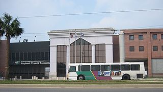
The New Orleans Regional Transit Authority is a public transportation agency based in New Orleans. The agency was established by the Louisiana State Legislature in 1979, and has operated bus and historic streetcar service throughout the city since 1983, when it took over the city's mass transit system after nearly six decades' control by New Orleans Public Service, Inc.. In 2023, the system had a ridership of 9,707,300, or about 29,700 per weekday as of the third quarter of 2024, making the Regional Transit Authority the largest public transit agency in the state of Louisiana.

Kenner is a city in the U.S. state of Louisiana. It is the most populous city in Jefferson Parish, and is the largest incorporated suburban city of New Orleans. The population was 66,448 at the 2020 census, making it the sixth-most populous city in Louisiana.

Metairie is an unincorporated community and census-designated place (CDP) in Jefferson Parish, Louisiana, United States, and is part of the New Orleans metropolitan area. With a population of 143,507 in 2020, Metairie is the largest community in Jefferson Parish and was the fifth-largest CDP in the United States. It is an unincorporated area that would have been Louisiana's fourth-largest city behind Shreveport if incorporated.

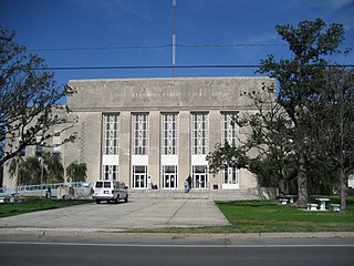
Chalmette is a census-designated place (CDP) in, and the parish seat of, St. Bernard Parish in southeastern Louisiana, United States. The 2010 census reported that Chalmette had 16,751 people; 2011 population was listed as 17,119; however, the pre-Katrina population was 32,069 at the 2000 census. At the 2020 U.S. census, its population rebounded to 21,562. Chalmette is part of the New Orleans–Metairie–Kenner metropolitan statistical area. Chalmette is located east of downtown New Orleans and south of Arabi, towards Lake Borgne.

Hammond is the largest city in Tangipahoa Parish, Louisiana, United States, located 45 miles (72 km) east of Baton Rouge and 45 miles (72 km) northwest of New Orleans. Its population was 20,019 in the 2010 U.S. census, and 21,359 at the 2020 population estimates program.
Houma is the largest city in and the parish seat of Terrebonne Parish in the U.S. state of Louisiana. It is also the largest principal city of the Houma–Bayou Cane–Thibodaux metropolitan statistical area. The city's government was absorbed by the parish in 1984, which currently operates as the Terrebonne Parish Consolidated Government.

Streetcars have been an integral part of the public transportation network of New Orleans since the first half of the 19th century. The longest of the city's streetcar lines, the St. Charles Avenue line, is the oldest continuously operating street railway system in the world. Today, the streetcars are operated by the New Orleans Regional Transit Authority (RTA).

Delgado Community College(DCC) is a public community college in Louisiana, with campuses throughout the New Orleans metropolitan area. Its current campuses are in New Orleans (Orleans Parish) and in Jefferson Parish. The original City Park Campus is located in the Navarre neighborhood adjacent to New Orleans City Park.
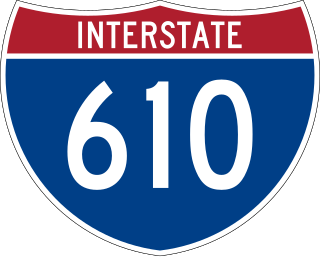
Interstate 610 (I-610) is a 4.52-mile-long (7.27 km) auxiliary route of I-10 that lies almost entirely within the city limits of New Orleans, Louisiana, bypassing its Central Business District.

The Lower Ninth Ward is a neighborhood in the city of New Orleans, Louisiana. As the name implies, it is part of the 9th Ward of New Orleans. The Lower Ninth Ward is often thought of as the entire area within New Orleans downriver of the Industrial Canal; however, the City Planning Commission divides this area into the Lower Ninth Ward and Holy Cross neighborhoods.

The St. Charles Streetcar Line is a historic streetcar line in New Orleans, Louisiana. Running since 1835, it is the oldest continuously operating streetcar line in the world. It is operated by the New Orleans Regional Transit Authority (RTA). Officially the St. Charles Streetcar line is designated as Route 12, and it runs along its namesake, St. Charles Avenue. It is the busiest route in the RTA system as it is heavily used by local commuters and tourists. On most RTA maps and publications, it is denoted in green, which is also the color of the streetcars on this line.

Louisiana Highway 47 (LA 47) is a state highway located in southeastern Louisiana. It runs 15.91 miles (25.60 km) in a general southeast to northwest direction from the Mississippi River levee in Chalmette to the intersection of Hayne Boulevard and Downman Road in New Orleans.

Fazendeville was a small, historic, African American community in St. Bernard Parish, Louisiana, United States. Located near the Freedmen's Cemetery in the parish, this village was razed during the 1960s as part of an expansion of the Chalmette National Battlefield in the Jean Lafitte National Historic Park and Preserve.
The Crescent City Connection Division (CCCD) is an agency within the Louisiana Department of Transportation and Development. The purpose of the CCCD is to plan, construct, operate, maintain and police all Mississippi River crossings in Jefferson, Orleans, and St. Bernard Parishes. Prior to the 1989, the CCCD was known as the Mississippi River Bridge Authority (MRBA) and had control of only the Greater New Orleans Bridge (now the Crescent City Connection). The Crescent City Connection Bridge is the fifth busiest bridge in the nation. More than 33 million vehicles traverse the structure annually.

Streetcars or trolley(car)s were once the chief mode of public transit in hundreds of North American cities and towns. Most of the original urban streetcar systems were either dismantled in the mid-20th century or converted to other modes of operation, such as light rail. Today, only Toronto still operates a streetcar network essentially unchanged in layout and mode of operation.

Jefferson Parish Transit, formerly known as Jefferson Transit, is a public transportation provider in Jefferson Parish, Louisiana. It serves the most heavily suburbanized areas of Greater New Orleans, providing both local service and commuter access to New Orleans Central Business District.
