
Taunton is the county town of Somerset, England. It is a market town and has a minster church. Its population in 2011 was 64,621. Its thousand-year history includes a 10th-century monastic foundation, owned by the Bishops of Winchester, which was rebuilt as Taunton Castle by the Normans in the 12th century. Parts of the inner ward house were turned into the Museum of Somerset and Somerset Military Museum. For the Second Cornish uprising of 1497, Perkin Warbeck brought an army of 6,000; most surrendered to Henry VII on 4 October 1497. On 20 June 1685 in Taunton the Duke of Monmouth crowned himself King of England in a rebellion, defeated at the Battle of Sedgemoor. Judge Jeffreys led the Bloody Assizes in the Castle's Great Hall.

Taunton Deane was a local government district with borough status in Somerset, England. Its council was based in Taunton.

Wellington is a market town in Somerset, England. It is situated 7 miles (11 km) south west of Taunton, near the border with Devon, which runs along the Blackdown Hills to the south of the town. The town had a population of 16,669, which includes the residents of the parish of Wellington Without, and the villages of Tone and Tonedale.

Bishop's Hull is a village and civil parish in Somerset, England, in the western suburbs of Taunton. It includes the areas of Rumwell, Rumwell Park, Roughmoor and Longaller and is close to the River Tone. The parish, which includes the hamlet of Netherclay, has a population of 2,975 in total.

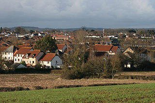
Cheddon Fitzpaine is a village and civil parish in Somerset, England, situated on the Quantock Hills 2 miles (3.2 km) north of Taunton. The village is situated near the Bristol and Exeter Railway, the Bridgwater and Taunton Canal, and the River Tone and has a population of 1,929.
Comeytrowe is a south western suburb of Taunton and former civil parish, now in the parish of Taunton in the county of Somerset, England. In 2011 the parish had a population of 5,463. The parish included the area of Galmington.
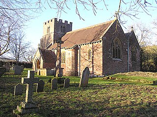
Tolland is a village and civil parish in Somerset, England, situated 9 miles (14.5 km) north west of Taunton, between the Brendon Hills and Quantock Hills. The parish has a population of 81.
Wiveliscombe is a town and civil parish in Somerset, England, situated 9 miles (14 km) west of Taunton. The town has a population of 2,893. The Square, fronted by several listed structures, held the former market. The parish includes the nearby hamlet of Maundown.

Richard Huish College is a further education and sixth-form college in Taunton, Somerset, England. Located on a single site in South Road, about a mile from the centre of Taunton, it offers A-level courses, apprenticeships and vocational courses.
Taunton Deane Borough Council in Somerset, England was elected every four years. The first elections to the council were held in 1973, ahead of it coming into being in 1974. The last election was held in 2015. The council was abolished in 2019 when the district merged with neighbouring West Somerset district to become Somerset West and Taunton.

Somerset Council, known until 2023 as Somerset County Council, is the local authority for the non-metropolitan county of Somerset in South West England. Since 2023 it has been a unitary authority, being a county council which also performs the functions of a district council. The non-metropolitan county of Somerset is smaller than the ceremonial county, which additionally includes Bath and North East Somerset and North Somerset.

The Municipal Buildings are historic buildings in Corporation Street, Taunton, Somerset, England. The buildings, which were the home of Taunton Grammar School before becoming the headquarters of Taunton Borough Council, are Grade II* listed.

Musgrove Park Hospital is a large NHS hospital located in Taunton, Somerset, England, run by Somerset NHS Foundation Trust. Originally a US Army General Hospital during the Second World War, it became an NHS hospital in 1951.

The Museum of Somerset is located in the 12th-century great hall of Taunton Castle, in Taunton in the county of Somerset, England. The museum is run by South West Heritage Trust, an independent charity, and includes objects initially collected by the Somerset Archaeological and Natural History Society who own the castle.

Taunton Castle is a castle built to defend the town of Taunton, Somerset, England. It has origins in the Anglo Saxon period and was later the site of a priory. The Normans then built a stone structured castle, which belonged to the Bishops of Winchester. The current heavily reconstructed buildings are the inner ward, which now houses the Museum of Somerset and the Somerset Military Museum. The building was designated a grade I listed building in 1952.

Taunton Minster (St Mary Magdalene church) is a Church of England parish minster church in Taunton, Somerset, England, dedicated to Jesus' companion Mary Magdalene. It was completed in 1508 and is in the Early Tudor Perpendicular Gothic style. It is designated as a Grade I listed building. It is notable for its very tall tower.

The Crescent is a street in Taunton, a town in the English county of Somerset. Construction began in 1807, during a period of extensive redevelopment in the town, driven by the Market House Society and the Member of Parliament Sir Benjamin Hammet. Lined on the eastern side by a Georgian terrace, the street follows a shallow crescent shape, broken in the middle by Crescent Way and a bit further south by St George's Place. It links Upper High Street, at its southern end, with Park Street and Tower Street to the north. On the western side, Somerset County Council have their offices in the County Hall, erected in 1935, and extended in the 1960s. The Georgian terrace, the Masonic Hall, and the County Hall are recorded in the National Heritage List for England as listed buildings.

The 2011 Taunton Deane Borough Council election took place on 5 May 2011 to elect members of Taunton Deane Borough Council in Somerset, England. The whole council was up for election and the council stayed under no overall control. The Conservatives won 28 seats, exactly half, while the Liberal Democrats took 23. Labour only won three seats, with the two remaining held by independent candidates. Falling only one seat short of an overall majority, the Conservatives took on the leadership of the council as a minority administration, under Councillor John Williams.

Somerset West and Taunton was a local government district in Somerset, England, from 2019 to 2023. It was established on 1 April 2019 by the Somerset West and Taunton Order 2018. The council replaced the Taunton Deane and West Somerset councils, which governed the same area from 1974.

Taunton Shire Hall is a municipal building on Shuttern in Taunton, Somerset. The Shire Hall, which serves as a Crown Court, is a Grade II listed building.

