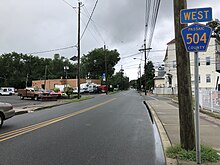
Route 28 is a state highway in the central part of New Jersey, United States that is 26.44 mi (42.55 km) long. Its western terminus is at U.S. Route 22 (US 22) in Bridgewater Township, Somerset County, while its eastern terminus is at Route 27 in Elizabeth, Union County. From its western terminus, Route 28 heads east through Raritan, intersecting County Route 567 (CR 567) and then US 202 and US 206 at the Somerville Circle before heading through the central part of Somerville. Past Somerville, the route has interchanges with Interstate 287 (I-287) in Bridgewater Township before intersecting many 500-series county roads including CR 525 and CR 527 in Bound Brook, CR 529 in Dunellen, Middlesex County, CR 531 in Plainfield, Union County, and CR 509 in Westfield. Route 28 continues east, intersecting Route 59 and the Garden State Parkway in Cranford before heading to Elizabeth, where it crosses Route 439 before ending at Route 27. Route 28 is a two- to four-lane road its entire length that passes through suburban areas and runs within a close distance of New Jersey Transit’s Raritan Valley Line for much of its length.

Route 27 is a state highway in New Jersey, United States. It runs 38.5 mi (61.96 km) from US 206 in Princeton, Mercer County, northeast to an interchange with McCarter Highway and Broad Street in Newark, Essex County. The route passes through many communities along the way, including New Brunswick, Highland Park, Edison, Metuchen, Rahway, and Elizabeth. Route 27 is a two- to four-lane undivided highway for most of its length, passing through a variety of urban and suburban environments. It intersects and interchanges many roads along the way, including Route 18 in New Brunswick, I-287 in Edison, the Garden State Parkway in Woodbridge, Route 35 in Rahway, Route 28 in Elizabeth, and U.S. Route 22 in Newark. Route 27 crosses the Raritan River on the Albany Street Bridge, which connects Highland Park on the east with New Brunswick on the west.

Route 3 is a state highway in the northeastern part of New Jersey. The route runs 10.84 miles (17.45 km) from U.S. Route 46 (US 46) in Clifton, Passaic County, to US 1/9 in North Bergen, Hudson County. The route intersects many major roads, including US 46, which takes travelers to Interstate 80 (I-80) west for commuting out of the city-area, the Garden State Parkway and Route 21 in Clifton, Route 17 and the Western Spur of the New Jersey Turnpike (I-95) in East Rutherford, the Eastern Spur of the New Jersey Turnpike in Secaucus, and Route 495 in North Bergen, for traffic going to the Lincoln Tunnel into New York City. Route 3 serves as the main artery to the Lincoln Tunnel from I-80, in conjunction with a portion of US 46 and Route 495. Portions of the route are not up to freeway standards; with driveways serving businesses and bus stops. Despite this, many construction projects have been underway over the years to alleviate this issue. Route 3 also provided access to Hoffmann La Roche's former American headquarters in Nutley, the Meadowlands Sports Complex and American Dream in East Rutherford. The road inspired a story in The New Yorker in 2004 by Ian Frazier due to its views of the Manhattan skyline. Route 3 was originally the Lincoln Tunnel Approach and ended at the state line in the Hudson River, though it was scaled back following the construction of I-495; which is now Route 495 due to also not meeting interstate highway standards.

Route 7 is a state highway in the northern part of New Jersey in the United States. It has two sections, an east–west alignment running from U.S. Route 1/9 Truck in Jersey City to the Passaic River in Belleville, and a north–south alignment running from the Newark/Belleville to the Nutley/Clifton border. The New Jersey Department of Transportation (NJDOT) lists Route 7 as a single north–south highway with a small gap between the alignments. The entire highway has a combined length of 9.46 mi (15.22 km).

Route 23 is a state highway in the northern part of New Jersey, United States. The route runs 52.63 miles (84.70 km) from Bloomfield Avenue and Prospect Avenue (CR 577) in Verona, Essex County, northwest to the border with New York at Montague Township in Sussex County, where the road continues to Port Jervis, New York, as CR 15. Route 23 heads through Essex and Passaic counties as a two- to four-lane surface road and becomes a six-lane freeway north of a complex interchange with U.S. Route 46 (US 46) and Interstate 80 (I-80) in Wayne. The freeway carries Route 23 north to run concurrently with US 202. Past the freeway portion, the route heads northwest along the border of Morris and Passaic counties as a four- to six-lane arterial road with a wide median at places, winding through mountainous areas and crossing the interchange with I-287 in Riverdale. The route continues northwest through Sussex County as a mostly two-lane surface road that passes through farmland and woodland as well as the communities of Franklin, Hamburg, and Sussex before reaching the New York state line, just south of an interchange with I-84 and US 6 in Port Jervis, in Montague Township near High Point State Park.
U.S. Route 46 (US 46) is an east–west U.S. Highway completely within the state of New Jersey, and runs for 75.34 mi (121.25 km). The west end is at an interchange with Interstate 80 (I-80) and Route 94 in Columbia, Warren County, on the Delaware River. The east end is in the middle of the George Washington Bridge over the Hudson River in Fort Lee, Bergen County, while the route is concurrent with I-95 and US 1-9. Throughout much of its length, US 46 is closely paralleled by I-80. US 46 is a major local and suburban route, with some sections built to or near freeway standards and many other sections arterials with jughandles. The route runs through several communities in the northern part of New Jersey, including Hackettstown, Netcong, Dover, Parsippany-Troy Hills, Wayne, Clifton, Ridgefield Park, Palisades Park, and Fort Lee. It crosses over the Upper Passaic River at several points. The road has been ceremonially named the United Spanish–American War Veterans Memorial Highway.
The Newark-Pompton Turnpike, is a roadway in northern New Jersey that was originally a tolled turnpike. The roadway was first laid out in the mid-18th century and given its name in 1806. As originally designed, it connected Newark with the area north and west of the Pompton River in what is now Riverdale. Its south end is Broadway in Newark; its north end is the Paterson-Hamburg Turnpike. As such, it was part of an alternate route between Newark and Paterson.

County Route 553 is a county highway in the U.S. state of New Jersey. The highway extends 51.22 miles (82.43 km) from Hands Landing Road/Ogden Avenue in Commercial Township to Broadway in Deptford Township.
County Route 541 is a county highway in the U.S. state of New Jersey. The highway extends 23.8 miles (38.3 km) from US 206 in Shamong to US 130/CR 543 in Burlington.

County Route 540 is a county highway in the U.S. state of New Jersey. The highway extends 43.16 miles (69.46 km) from the intersection of U.S. Route 130 (US 130) and Route 140 in Carneys Point Township to Harding Highway (US 40) in Buena Vista Township.

County Route 517 is a county highway in the U.S. state of New Jersey. The highway extends 53.8 miles (86.58 km) from Lamington Road / Oldwick Road in Tewksbury to the New York state line in Vernon where it continues as Orange County Route 26. It passes through mostly rural and exurban communities. Its speed limit varies from as much as 50 mph (80 km/h) to as little as 25 mph (40 km/h).

County Route 514 is a county highway in the U.S. state of New Jersey. The highway extends 42.86 miles (68.98 km) from its western terminus U.S. Route 202 (US 202) and Route 31 in East Amwell Township to its eastern terminus Edgar Road in Elizabeth. West of its western terminus, CR 514 continues as Route 179.

County Route 513 is a county highway in the U.S. state of New Jersey. The highway extends 66.83 miles (107.55 km) from Kingwood Avenue in Frenchtown to Lakeside Road in West Milford. South of Frenchtown, the road continues as Route 29. It is the third longest county route in New Jersey, following CR 519 and CR 527.

County Route 512 is a county highway in the U.S. state of New Jersey. The highway extends 32.96 miles (53.04 km) from High Bridge Road in Califon to Springfield Avenue / Route 24 in Summit.

County Route 511 is a county highway in the U.S. state of New Jersey. The highway extends 37.44 miles (60.25 km) from Columbia Avenue in Morris Township to the New York state line in West Milford where the road continues as New York State Route 210.

County Route 510 (CR 510) is a county highway in the U.S. state of New Jersey. The highway extends 29.58 miles (47.60 km) from North Road (CR 513) in Chester to McCarter Highway in Newark.
County Route 507 is a county highway in the U.S. state of New Jersey. The highway extends 28.37 mi (45.66 km) from CR 508 in Harrison to the New York state line in Mahwah. Between Ho-Ho-Kus and Mahwah, this highway is known as Franklin Turnpike. At its northern terminus, County Route 507 continues north into New York as Orange Avenue, which is a portion of U.S. Route 202 (US 202).

County Route 506 is a county highway in the U.S. state of New Jersey. The highway extends 10.78 miles (17.35 km) from Route 159 in Fairfield to the Passaic River in Belleville.

County Route 502 (CR 502) is a county highway in the U.S. state of New Jersey. The highway extends 23.79 miles (38.29 km) from Paterson-Hamburg Turnpike (CR 504) in Wayne to Palisades Boulevard (US 9W) in Alpine.

U.S. Route 202 (US 202) is a U.S. Highway running from New Castle, Delaware northeast to Bangor, Maine. In the U.S. state of New Jersey, the route runs 80.31 mi (129.25 km) from the New Hope–Lambertville Toll Bridge over the Delaware River at the Pennsylvania border in Delaware Township, Hunterdon County, near Lambertville northeast to the New York border in Mahwah, Bergen County. Along the route's journey, it passes through a variety of suburban and rural environments, including the communities of Flemington, Somerville, Morristown, Parsippany-Troy Hills, Wayne, and Oakland as well as five counties: Hunterdon, Somerset, Morris, Passaic, and Bergen. US 202 encounters many major roads in New Jersey, including Route 31, US 206, US 22, Interstate 80 (I-80), US 46, Route 23, and Route 17. From Somerville to the New York border, US 202 generally runs within a close distance of I-287 and interchanges with that route several times. The road ranges from a four-lane freeway between Lambertville and Ringoes in Hunterdon County to a two-lane surface road through much of the northern portion of the route. North of the Route 53 intersection in Morris Plains, US 202 is maintained by individual counties rather than the New Jersey Department of Transportation with a few exceptions.