This article needs additional citations for verification .(May 2019) |

Cove Road in Nova Scotia
Cove Road is a community in the Canadian province of Nova Scotia, located in Colchester County .
This article needs additional citations for verification .(May 2019) |
Cove Road is a community in the Canadian province of Nova Scotia, located in Colchester County .

Peggy's Cove is a small rural community located on the eastern shore of St. Margarets Bay in the Halifax Regional Municipality, which is the site of Peggys Cove Lighthouse.
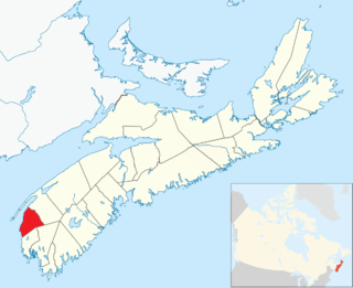
Clare, officially named the Municipality of the District of Clare, is a district municipality in western Nova Scotia, Canada. Statistics Canada classifies the district municipality as a municipal district.

The Diocese of Nova Scotia and Prince Edward Island is a diocese of the Ecclesiastical Province of Canada of the Anglican Church of Canada. It encompasses the provinces of Nova Scotia and Prince Edward Island and has two cathedrals: All Saints' in Halifax and St. Peter's in Charlottetown. Its de facto see city is Halifax, and its roughly 24 400 Anglicans distributed in 239 congregations are served by approximately 153 clergy and 330 lay readers according to the last available data. According to the 2001 census, 120,315 Nova Scotians identified themselves as Anglicans, while 6525 Prince Edward Islanders did the same.

The Halifax Regional Municipality has a number of parks and recreation areas in urban and rural settings.
The Lighthouse Route is a scenic roadway in the Canadian province of Nova Scotia. It follows the province's South Shore for 585 km (364 mi) from Halifax to Yarmouth.
Fergusons Cove is a suburban community within the Halifax Regional Municipality (HRM), Nova Scotia on the western shore of Halifax Harbour between Purcell's Cove and Herring Cove along Route 253. The first 3 digits of the postal code in the area are B3V.
Birch Cove is a subdivision and a cove in the community of Bedford within the Halifax Regional Municipality in Nova Scotia, Canada, on the shore of Bedford Basin and along the Bedford Highway.
Pennant Point is a rural community located at the head of Pennant Harbour near Sambro on the Chebucto Peninsula in the Halifax Regional Municipality Nova Scotia on Route 349.
Melville Cove is a residential subdivision in Armdale on Mainland Halifax within the Halifax Regional Municipality Nova Scotia on the shore of the Northwest Arm in Halifax Harbour.

St. John's Anglican Church is a historic Carpenter Gothic style Anglican church building located at 8 Church Road in Peggys Cove, Nova Scotia, Canada. Built in 1893–94 of wood, St. John's is the only church in Peggys Cove. Its steep pitched roof, board and batten siding and lancet windows are typical of Carpenter Gothic churches. The church contains two murals painted in 1963 by noted Canadian artist and local resident William E. deGarthe.

Indian Harbour is a small fishing community of the Halifax Regional Municipality in the Canadian province of Nova Scotia on the Chebucto Peninsula. It is located between the communities of Peggy's Cove and Hackett's Cove.

Aulds Cove is a community in the Canadian province of Nova Scotia, located in both Antigonish County and Guysborough County.
Malignant Cove is a small community in the Canadian province of Nova Scotia, located in Antigonish County. It was named for the sailing vessel Malignant, which ran aground there during the American Revolution. It was renamed Milburn in 1915 but the new name was not adopted by the community. The founder of The Casket, John Boyd, began as a printer in Malignant Cove.

Irish Cove(Golhamkitk) is a small community in the Canadian province of Nova Scotia, spanning the border that divides Richmond County and Cape Breton County. The community is also home to a provincial picnic park.
Sandy Cove is a community of the Halifax Regional Municipality in the Canadian province of Nova Scotia on the Chebucto Peninsula.
Livingstone Cove is a community in the Canadian province of Nova Scotia, located in Antigonish County.
There are various Black Lakes in Nova Scotia, Canada. They vary widely in size, depth and usability. Many counties, such as Cumberland, Halifax, Inverness, and Pictou Counties have more than one Black Lake so named, while other counties mentioned in this article have only one named Black Lake.
Herring Cove is a Canadian suburban and former fishing community in Nova Scotia's Halifax Regional Municipality. It is situated on the eastern shore of the Chebucto Peninsula, 15 km (9.3 mi) south of Downtown Halifax. It is near the western approaches to Halifax Harbour, and can be reached both via Purcell's Cove along the coastal road and from inland via the Herring Cove Road through Spryfield. There are two schools in Herring Cove, William King Elementary and Herring Cove Junior High. The community is also home to a small variety of small businesses and programs.
CIRP-FM is a non-profit radio station which broadcasts a Christian radio format from Spryfield, Nova Scotia, and serving the Halifax, Nova Scotia market. The station is owned by City Church of Halifax on Herring Cove Road. CIRP-FM plays Light Christian Contemporary music in the morning and Southern Gospel music later in the day.

The Louisbourg Lighthouse Trail is a hiking trail on Cape Breton Island in the Canadian province of Nova Scotia. The trailhead is located on Lighthouse Point, at the Louisbourg Lighthouse, within the Fortress of Louisbourg National Historic Site. The Louisbourg Lighthouse is the site of Canada’s first lighthouse which was built here in 1734.
| | This Colchester County, Nova Scotia location article is a stub. You can help Wikipedia by expanding it. |