Cowden Hall, East Renfrewshire

Last updated

Cowden Hall
Neilston, East Renfrewshire, Scotland
UK grid reference NS4669257162
Old Cowden Hall, west facing side.JPG
Remnants of Cowden Hall
Scotland relief location map.jpg
Red pog.svg
Cowden Hall
Coordinates 55°47′00″N4°26′46″W / 55.783391°N 4.446249°W / 55.783391; -4.446249
TypeA hall-house
Site information
OwnerPrivate
Open to
the public
No
ConditionPartly demolished and 'robbed'
Site history
Built17th century
Built byThe Cochrane Clan
MaterialsStone

Cowden Hall, Cowdon Hall [1] or Cowdenhall is an example of a laird's hall-house with a farmstead dating from more peaceful times in the seventeenth century when gun loops, thick defensive walls and well defended entrances were no longer essential and larger windows could be utilised. [2] Eighteenth century additions included an outshot with a cruck roof. [3] Cowden is located in an elevated position overlooking the Neilston Gap and the Levern Water on the lands of the old Barony of Cowden near Neilston in East Renfrewshire, Scotland.

Contents

History

A building may have stood on or near to the site prior to the seventeenth century as indicated by the name ‘Kouden’ that is recorded on Timothy Pont’s Renfrewshire map that dates from between 1583 and 1596. [4] In 1695 the name 'Couldoune' is recorded on the Poll Tax Roll [5] when Thomas Spreull lived at Smithhills of Couldoune (now Smiddyhill Farm?) with his three children; John Spreull lived here with his wife Margaret Gardiner; James Spreull lived at Knowglass (now Knockglass?) with his wife Margaret Dinsmuir; John Stewart lived at Couldoune Mill; Huw Cochrane lived in Couldoune. [6] The name 'Cowden' may derive from the Gaelic 'Caltuinn' for 'Hazel' and valley. [7]

Although Cowden overlooks the Neilston Gap it was not always the main thoroughfare as Roy's 1750s map shows no track here with the cart track from Irvine to Glasgow running past Glanderston with a branch to Neilston running fairly close to Cowden Hall. [8]

Lairds

The surviving gable end of the probable 18th century addition. Old Cowden Hall, South facing aspect.JPG
The surviving gable end of the probable 18th century addition.

Sir Robery Croc of Crookston Castle held lands in Neilston in the 12th century and is thought to have held a castle that may have been at Cowden. [9] From the fourteenth century the Spreull or Spreul family of Dalmuir held the barony however in 1622 it was purchased from James Spreull by Alexander Blair who changed his name to Alexander Cochrane of Dundonald in South Ayrshire. [10] Walter Spreull of Cowden was High Steward of Dumbarton and a member of a family who had a long association with the parish of Neilston. He was a retainer of Malcolm, Earl of Lennox in the early fourteenth century at the time of Robert the Bruce. In 1545 Mary Queen of Scots granted the lands of Cowden to Spreulls for good service indicating a short period from 1441 when the family did not hold the barony (however see below).

Robertson records that Walter Spreul passed the lands of 'Coudoun' to his son Thomas in 1441, they then passed to John his son in 1481 and likewise to Robert in 1515. Two John Spreuls followed in succession and the male line ended with James who in 1622 sold the lands as previously recorded. [11] The Spreuls of Miltoun and John Spreul of Glasgow were descendants of the Spreuls of Cowden. [12]

In 1531 the laird of Cowden was involved in a feud with the laird of Colgrane. [13] In 1549 a Thomas Sprewill de Coldon (sic) is recorded. [14]

In 1507 John Spreul, a younger son of the family, became the vicar of Dunlop as well as a professor of philosophy at Glasgow University and then Rector. He went on to become a prebend at Glasgow Cathedral and in 1541 he was a dean, dying in 1555, leaving his property to his nephew John, son of his brother Robert who was a burgess of the Glasgow. [15]

William Cochrane of Cowden was responsible for building the hall whose ruins survive in part with later additions also extant in a ruinous condition. [16] As stated the estate in 1622 was sold to Alexander Blair of that Ilk who married a Cochrane heiress and adopted her name, the family becoming Earls of Dundonald. [17] Eventually Cowden passed to the Marquis of Clydesdale via his mother who was a daughter of the Earl of Dundonald. The marquis, on becoming the Duke of Hamilton, sold the lands to the Mures of Caldwell in 1776 who still held the property in 1910. [18]

Coventry records that the Spreulls held Cowden from 1306 and that they sold the lands to the Blairs, the lands eventually passing to the Mures of Craigends in 1776. [19]

Coat of arms

The Spreulls of Cowdon occupied lands which controlled the road south to Ayrshire. The armorial bearing of the Spreuls of Coudoun was, "Or; a Chevron Checquie, Azure and Argent; betwixt three Purses, Guiles. [20] This translates as a chevron with a chessboard-like background of blue and silver squares and three red purses spread between all on a gold background. [21]

Saint Matthew was a tax-gatherer and bags on coats of arms often denoted a treasurer or some other linked occupation. The Spreulls may have had a link with collecting tolls from travellers. [22]

The Spreulls of Cowden were related to the Spreulls of Ladymuir, Castlehill and Blachairne. [23]

Cowden Hall-house

A 'slot feature' in the southern section of the ruins. Old Cowden Hall - feature.JPG
A 'slot feature' in the southern section of the ruins.

In 1831 a print of the hall indicates that the main part of the complex faced the Neilston Gap and today's ruins may have been left as an estate worker's accommodation and outbuilding when the new Cowden Hall was built and stone robbed from here was probably used in its construction or for the extensive landscaping works that stood nearby such as the loch's dam. [24]

Two abandoned buildings, standing about 20 metres (65 feet) apart are recorded on the 1st edition of the Ordnance Survey 1:2500 map standing respectively within a rectilinear enclosure. [25] One of these buildings was a range containing two compartments of unequal size. An outbuilding projected from the south-west end of the range. The totally demolished building was 'L' shaped in plan [26] and had been removed by 1897. [27]

The surviving remains of the hall consist of a rectangular structure on a north-west to south-east axis with a central division that suggest two phases of construction as one half has walls that are narrower than the other. A dominant feature in the northern section is a fireplace with a substantial lintel, the remnants of window locations are discernible. [28] Pink harling was evidently used. [29] Prominent slots feature in the southern section of the surviving building may have been used for timber beams hinting at a cruck and thatched roof on a single storey building. [30]

Throughout only basic stone dressing was used employing lime mortar and rubble without clear coursing. A lean-to feature may have adjoined the southern end of the building. [31]

In 1910 it is recorded that the old hall was surrounded by woodland composed of ancient forest sized trees including sycamore, ash and beech. [32]

Crofthead House and the new Cowden Hall

Old Cowden Hall ruins from the east. Old Cowden Hall, East facing aspect.JPG
Old Cowden Hall ruins from the east.

In 1792 a cotton mill was constructed by James Orr at Crofthead below Neilston and Crofthead House was built in the 1830s, demolished and replaced by Robert Orr, a nephew, in the 1860s. The new mansion house of Cowden that was built had extensive formal landscaped gardens, an ornamental loch, walled gardens, an extensive complex of conservatories, etc. [33]

In 1964 the 'new' Cowden Hall, the stables, conservatories, glasshouses, North Lodge, etc were demolished. The walled garden survives as well as the South Lodge. [34]

Micro-history

The Kilbarchan the 1723 Weavers Cottage has a cruck roof along the lines of what may have existed at Cowden Hall. [35]

The ruins have changed little since 1910 apart from the part collapse of the southern gable end. [36]

The Cowden Burn's course was altered at the time of the construction of the railway through the Neilston Gap and now runs in a man made channel to the north side of the road and next to the railway. [37]

A parliament was attended in 1572 by Thomas Spreull, Laird of Cowden. [38]

Related Research Articles

East Renfrewshire Council area of Scotland

East Renfrewshire is one of 32 council areas of Scotland. Until 1975, it formed part of the county of Renfrewshire for local government purposes along with the modern council areas of Renfrewshire and Inverclyde. Although no longer a local authority area, Renfrewshire still remains the registration county and lieutenancy area of East Renfrewshire.

Barrhead Town in East Renfrewshire, Scotland

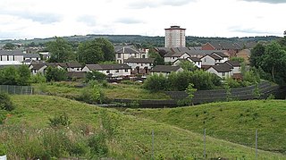
Barrhead is a town in East Renfrewshire, Scotland, thirteen kilometres (8 mi) southwest of Glasgow city centre on the edge of the Gleniffer Braes. At the 2011 census its population was 17,268.

Johnstone Town in Scotland

Johnstone is a town in the administrative area of Renfrewshire and larger historic county of the same name, in the west central Lowlands of Scotland.

Neilston Village in East Renfrewshire, Scotland

Neilston is a village and parish in East Renfrewshire in the west central Lowlands of Scotland. It is in the Levern Valley, two miles southwest of Barrhead, 3+34 miles south of Paisley, and 5+34 miles south-southwest of Renfrew, at the southwestern fringe of the Greater Glasgow conurbation. Neilston is a dormitory village with a resident population of just over 5,000 people.

Renfrewshire (historic) Historic county and lieutenancy area of western Scotland

Renfrewshire or the County of Renfrew is a historic county, registration county and lieutenancy area in the west central Lowlands of Scotland. It contains the local government council areas of Inverclyde, Renfrewshire and East Renfrewshire, as well as parts of Glasgow and is occasionally named Greater Renfrewshire to distinguish the county from the modern council area.

Clan Cochrane Lowland Scottish clan

Clan Cochrane is a Scottish clan of the Scottish Lowlands.

Barony and Castle of Corsehill Barony in East Ayrshire, Scotland

The old Barony and castle of Corsehill lay within the feudal Baillerie of Cunninghame, near Stewarton, now East Ayrshire, Scotland.

The Glasgow, Barrhead and Kilmarnock Joint Railway was a railway jointly owned by the Caledonian Railway and the Glasgow and South Western Railway, completed in 1873, and giving the latter a shorter access to its Carlisle main line. A branch to Beith was also built.

Montgreenan

Montgreenan is an estate in North Ayrshire, Parish of Kilwinning, Scotland. The Lugton Water runs through the policies and farmland of Montgreenan. Nearby are the hamlets of Torranyard and Auchentiber.

Caldwell, East Renfrewshire

Caldwell is a mansion and old estate with the remains of a castle nearby. These lands lie close to the Lugton Water and the villages of Uplawmoor in East Renfrewshire and Lugton in East Ayrshire.

Polnoon Castle

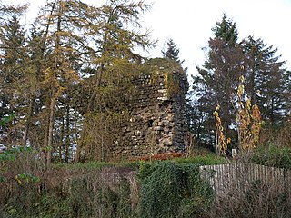
Polnoon Castle was a 14th-century fortification located on a motte beside the Polnoon Water in Millhall, in the Parish of Eaglesham, East Renfrewshire, Scotland.

Renfrew Human settlement in Scotland

Renfrew is a town 6 miles (10 km) west of Glasgow in the west central Lowlands of Scotland. It is the historic county town of Renfrewshire. Called the "Cradle of the Royal Stewarts" for its early link with Scotland's former royal house, Renfrew gained royal burgh status in 1397.

Auchenbathie Tower

Auchenbathie, Auchinbathie Tower or rarely Barcraigs Tower is a ruined fortification, a tower house, once held by the Wallace Clan of Elderslie, situated in Renfrewshire, Parish of Lochwinnoch, Scotland. The spelling used varies greatly and "Auchenbathie" will be used here as the standard spelling. The pronunciation locally is "Auchenbothy", the same as a Victorian mansion in Kilmacolm; no connection is known.

The lands of Finnart to the west of Greenock belonged to the Earl of Douglas in medieval times. Around 1455 they were forfeited to the crown. Finnart was given to the Hamiltons, while the western part of the barony of Finnart went to Stewart of Castlemilk and became the barony of Finnart-Stewart, or Gourock.

Shillford Human settlement in Scotland

Shillford or Shilford is a hamlet to the south-west of Barrhead on the Lochlibo Road in East Renfrewshire near Uplawmoor, Scotland in the parish of Neilston. It is located around 11 miles (18 km) south-west of Glasgow and north of Kilmarnock, and around 5 miles (8 km) south of Paisley.

Lands of Elliston

The lands of Elliston, previously Elliotston or Eliotstoun or Elliestoun in the Parish of Lochwinnoch were part of the holdings of the Barony of Elliston, later a part of the Castle Semple barony and estates. The ruins of the castle lie a short distance from Howwood in Renfrewshire in a private garden on a minor road between the A737 and the B776. The name may have derived from earlier holders of the lands, however the Sempill family held them since at least 1220. The castle was abandoned circa 1550 when John Sempill, 1st Lord Sempill moved to a new castle at Castleton which he renamed Castle Semple.

Duchal Castle

The ruins of the large courtyard style Duchal Castle lie circa 1.5 miles south-west of Kilmacolm in the Inverclyde council area and the historic county of Renfrewshire in the west central Lowlands of Scotland. The castle stands at the bottom of the valley of the River Gryfe on a peninsula created by the Blacketty and Green Waters which have their confluence beyond the two deep gorges.

Park Quay Port in Scotland

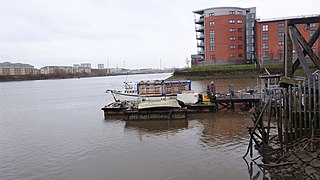
The disused Park Quay or Fulton's Quay is located on the old Lands of Park, situated on the south bank of the River Clyde in the Parish of Inchinnan, close to Newshot Island and the old Rashielee Quay. A slipway is also part of the infrastructure, giving access to the dock at low tide, both once served by roads running through the Park Estate from the south. It was recorded as Fulton's Quay in 1830, the name of a previous owner of the Park Estate who may have built it prior to 1801. A fixed light was installed at Park Quay in 1869.

Rashielee Quay Port in Scotland

The old Rashielee Quay or Rashielie Quay (NS471709) was located on the old Lands of North Barr, situated on the south bank of the River Clyde in the Parish of Inchinnan, between Bodinbo Island and Park Quay. It was built to facilitate the loading of boats and barges with whinstone excavated from the nearby Rashielee Quarries that was brought to the quay by a horse drawn wagonway.

Kings Inch Small Scottish island

King's Inch and the much smaller Sand Inch were islands lying in the estuarine waters of the River Clyde close to Renfrew in Renfrewshire, Scotland. Due to dredging and a change of the course of the main current of the River Clyde, silting, etc. it has become part of the southern, Renfrewshire side, of the river bank and is now built over.

References

Notes
  1. Cowdon Hall on the Canmore site
  2. Alexander, p.154
  3. Cowdon Hall on the Canmore site
  4. Cowdon Hall on the Canmore site
  5. Pride, p.232
  6. Pride, p.232
  7. Pride, p.210
  8. Roy's Military Map
  9. Mason, p.93
  10. Alexander, p.157
  11. Robertson, p.44
  12. Robertson, p.44
  13. Metcalfe, p.103
  14. Metcalfe, p.103
  15. Metcalfe, p.104
  16. Alexander, p.158
  17. Mason, p.93
  18. Pride, p.170
  19. Coventry, p.542
  20. Robertson, p.44
  21. Glossary of Heraldic Terms.
  22. The Heraldry Society of Scotland. Archived 2006-12-08 at the Wayback Machine
  23. Metcalfe, p.104
  24. Alexander, p.158
  25. Renfrew Sheet XVI.2 (Neilston). Survey date: 1856. Publication date: 1863
  26. Mason, p.93
  27. Renfrewshire 016.02 (includes: Neilston). Publication date:1897. Revised: 1895
  28. Alexander, p.158
  29. Mason, p.93
  30. Mason, p.93
  31. Alexander, p.158
  32. Pride, p.170
  33. Cowdon Hall on the Canmore site
  34. Cowdon Hall on the Canmore site
  35. Alexander, p.202
  36. Pride, p.169
  37. Pride, p.169
  38. Mason, p.93
Sources