
Suffolk County is located in the Commonwealth of Massachusetts, in the United States. As of the 2020 census, the population was 797,936, making it the fourth-most populous county in Massachusetts. The county comprises the cities of Boston, Chelsea, Revere, and Winthrop. The traditional county seat is Boston, the state capital and the largest city in Massachusetts. The county government was abolished in 1999, and so Suffolk County today functions only as an administrative subdivision of state government and a set of communities grouped together for some statistical purposes. Suffolk County is located at the core of the Boston-Cambridge-Newton, MA-NH Metropolitan Statistical Area as well as the greater Boston-Worcester-Providence, MA-RI-NH-CT Combined Statistical Area.

West Roxbury is a neighborhood in Boston, Massachusetts bordered by Roslindale to the northeast, the village of Chestnut Hill and the town of Brookline to the north, the city of Newton to the northwest, the towns of Dedham and Needham to the southwest, and Hyde Park to the southeast. West Roxbury is often mistakenly confused with Roxbury, but the two are separated from each other by Roslindale and Jamaica Plain.

Roslindale is a primarily residential neighborhood of Boston, Massachusetts, bordered by Jamaica Plain, Hyde Park, West Roxbury and Mattapan. It is served by an MBTA Commuter Rail line, several MBTA bus lines and the MBTA Orange Line in nearby Jamaica Plain. Roslindale has its own branch of the Boston Public Library, the neighborhood is covered by Boston Police District E-5 in West Roxbury, Boston EMS Ambulance 17 is stationed in Roslindale, and the Boston Fire Department has a station on Canterbury Street which houses Ladder 16, Engine 53 & District Chief 12. Roslindale's original Engine Company 45, was deactivated on April 10, 1981, due to budget cuts. Roslindale was once called the "garden suburb" of Boston. The portion of the Arnold Arboretum south of Bussey Street is located in Roslindale.

Congress Street Grounds is a former baseball ground located in Boston, Massachusetts. The ballpark, as the name implies, was along Congress Street, near the intersection of Thompson Place, and not far from the Fort Point Channel on South Boston Flats, a newly filled in piece of land on Boston Harbor. The ground was home to the Boston Reds, that played in the Players' League in 1890 and the American Association in 1891.

The Cutler Majestic Theatre at Emerson College, in Boston, Massachusetts, is a 1903 Beaux Arts style theater, designed by the architect John Galen Howard. Originally built for theatre, it was one of three theaters commissioned in Boston by Eben Dyer Jordan, son of the founder of Jordan Marsh, a Boston-based chain of department stores. The Majestic was converted to accommodate vaudeville shows in the 1920s and eventually into a movie house in 1956 by Sack Cinemas.
The change to film came with renovations that transformed the lobby and covered up much of John Galen Howard's original Beaux-Arts architecture.
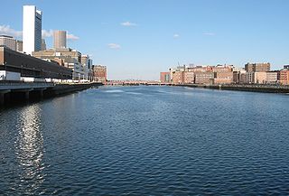
Fort Point Channel is a maritime channel separating South Boston from downtown Boston, Massachusetts, feeding into Boston Harbor. The south part of it has been gradually filled in for use by the South Bay rail yard and several highways. At its south end, the channel once widened into South Bay, from which the Roxbury Canal continued southwest where the Massachusetts Avenue Connector is now. The Boston Tea Party occurred at its northern end. The channel is surrounded by the Fort Point neighborhood, which is also named after the same colonial-era fort.

Forest Hills Cemetery is a historic 275-acre (111.3 ha) rural cemetery, greenspace, arboretum, and sculpture garden in the Forest Hills section of Jamaica Plain, a neighborhood in Boston, Massachusetts. The cemetery was established in 1848 as a public municipal cemetery for Roxbury, Massachusetts, but was privatized when Roxbury was annexed to Boston in 1868.

Long Wharf is a historic American pier in Boston, Massachusetts, built between 1710 and 1721. It once extended from State Street nearly a half-mile into Boston Harbor; today, the much-shortened wharf functions as a dock for passenger ferries and sightseeing boats.

The John D. O'Bryant School of Mathematics and Science, formerly known as Boston Technical High School is a college preparatory public exam school along with Boston Latin School and Boston Latin Academy. The O’Bryant specializes in science, technology, engineering and mathematics ("STEM") in the city of Boston, Massachusetts, and is named for one of Boston's prominent African-American educators John D. O'Bryant. The school is currently located on 55 Malcolm X Boulevard in the neighborhood of Roxbury, Massachusetts. With a student body of 1,500 7th–12th graders, this school is part of the Boston Public Schools.
The Edward M. Kennedy Academy for Health Careers is one of several Horace Mann Charter Schools in the Boston Public Schools system. On April 25, 2010, the school was renamed to honor the late senator, Edward M. Kennedy.

Downtown Boston is the central business district of Boston, Massachusetts, United States. Boston was founded in 1630. The largest of the city's commercial districts, Downtown is the location of many corporate or regional headquarters; city, county, state and federal government facilities; and many of Boston's tourist attractions. Similar to other central business districts in the U.S., Downtown has recently undergone a transformation that included the construction of new condos and lofts, renovation of historic buildings, and arrival of new residents and businesses. It is represented in the Boston City Council by District 2's Bill Linehan.

The Muddy River is a series of brooks and ponds that runs through sections of Boston's Emerald Necklace, including along the south boundary of Brookline, Massachusetts. The river, which is narrower than most waterways designated as rivers in the United States, is a protected public recreation area surrounded by parks and hiking trails, managed by the Massachusetts Department of Conservation and Recreation.
The Baker Street Jewish Cemeteries are a group of 42 Jewish cemeteries in use since the 1920s on Baker Street in the West Roxbury section of Boston. The cemeteries are located on land that once formed part of Brook Farm, a 19th-century communal-living experiment.

Uphams Corner, or Upham's Corner, is a commercial center in Dorchester, the largest neighborhood of Boston, Massachusetts. The intersection of Dudley Street/Stoughton Street and Columbia Road is the heart of Uphams Corner, and one of Dorchester's main business districts.

Milk Street is a street in the financial district of Boston, Massachusetts, which was one of Boston's earliest highways. The name "Milk Street" was most likely given to the street in 1708 due to a milk market at the location, although Grace Croft's 1952 work "History and Genealogy of Milk Family" instead proposes that Milk Street may have been named for John Milk, an early shipwright in Boston. The land was originally conveyed to his father, also John Milk, in October 1666.

Roxbury Heritage State Park is a history-themed heritage park in the oldest part of Roxbury, a former town annexed in 1868 by Boston, Massachusetts. It is anchored by the Dillaway–Thomas House, a large colonial structure built in 1750 and thought to be the oldest surviving house in Roxbury. The location includes an adjacent 1-acre (0.40 ha) landscaped park with views of the Boston skyline, and is part of the Metropolitan Park System of Greater Boston.

The Boston City Archives are located in West Roxbury, MA, and are the repository for all official records that must be kept to honor both the history of the municipal government in Boston and the legal rights of its citizens. The City Archives were established in 1988. The collection was originally housed in an old school building in Hyde Park, until the importance of preserving the expanding number of records became a focus of attention.

The First Church in Roxbury, also known as the First Church of Roxbury is the current headquarters of the Unitarian Universalist ("UU") Urban Ministry. A church on this site has been in use since 1632 when early English settlers built the first meetinghouse. Since then, the meetinghouse has been rebuilt four times, and its appearance today reflects how the meetinghouse looked in the late 19th and early 20th centuries.
The Old Village Cemetery is an historic cemetery in Dedham, Massachusetts.

Louis Weissbein (1831-1913) was a German-born American architect practicing in Boston, Massachusetts.