Cox and Hammond's Quay

Last updated

1857 map showing Cox's Quay (in grey; D, E, F) and Hammond's Quay (in orange; G, H). The wharf, marked I, served both sets of warehouses Cox & Hammonds Quay plan 1857 (cropped).jpg
1857 map showing Cox's Quay (in grey; D, E, F) and Hammond's Quay (in orange; G, H). The wharf, marked I, served both sets of warehouses

Cox & Hammond's Quay was a wharf located in the City of London, on the north bank of the River Thames a short distance downstream from London Bridge. It was originally two separate quays, Cox's Quay (also known as Cox's Key or Cock's Key) and Hammond's Quay, separated by Gaunt's Quay. On the landward side, the wharf was accessed via Lower Thames Street just behind the site of the church of St Botolph Billingsgate.

Contents

Origins

The wharf encompassed three of the twenty Legal Quays of the City of London, designated in the Act of Frauds of 1559. They were given state authorisation to serve as official landing and loading points for traders. Cox's Quay was designated as being "altogether for foreigners' goods who had merchandizes and lodgings" and Gaunt's Quay was "for landing of barrell fyshe and suche like havinge no crane". [1] The three quays already existed at that time, though the date of their establishments is not known. They were among the smallest of the legal quays and had a combined frontage of only 119 ft (36 m)54 ft (16 m) for Cox's Quay, 31 ft (9.4 m) for Gaunt's Quay and 23 ft (7.0 m) for Hammond's Quay. [2]

All three quays appear to have been named after owners; during the reign of Elizabeth I of England, Cox's Quay was recorded as having been demised from Richard Coke to Anne Cooke, either of which could have been the source of the quay's name. Gaunt's Quay was at some point absorbed into Hammond's Quay, and Cox and Hammond's Quays were both subsequently united. [3] [4] [5] The 18th century ownership of Gaunt's and Cox's Quays was somewhat unusual in that they were both owned and managed by a professional lighterman. [6] Hammond's Quay was owned for several centuries by the Vintners' Company, to which it had been bequeathed in 1439 by Thomas Crofton. He transferred his responsibilities as a trustee to the Company in exchange for an agreement that it would celebrate a service for the dead or dirige annually on 3 May at St Botolph Billingsgate. [7] In 1792 the Company attempted to offer the lease to the East India Company, which declined. Another man obtained the lease but in turn reassigned it to the East India Company in 1796. [8]

19th and 20th centuries

The two quays were bought out by the Treasury in 1805 for a cost of nearly £43,000 (equivalent to £3,712,000 today). [6] In 1836 the wharfinger John Knill, who owned Fresh Wharf immediately to the north, took over Cox's and Hammond's Quay as a tenant. [9] He had a new warehouse constructed over Cox's Quay in 1842. [10] Knill occupied five of the warehouses at Cox & Hammond's Quay in 1857, using them for fruit and non-hazardous goods, with eight more warehouses occupied by other tenants. They were described as all being of brick and in good repair, "age considered". [11] In 1869 it was reported that the wharf was to undergo rebuilding and unification with the neighbouring Botolph Wharf. [12] John Knill & Company (subsequently the Fresh Wharf Company) purchased the wharf outright in 1876. [9]

In the 1930s, the Fresh Wharf Company leased the whole of the river frontage from Cox and Hammond's Quay to London Bridge Wharf. [13] The warehouses of Fresh Wharf and Cox and Hammond's Quay were damaged during the Second World War by a V-1 flying bomb strike that demolished the nearby Nicholson's Wharf. [14] They were replaced in 1953 with a ten-storey warehouse constructed as part of the expanded New Fresh Wharf, [15] with four million cubic feet of storage space. [16] This only lasted twenty years; with the collapse in traffic to the London docks that followed the advent of containerization the wharf was made redundant and was demolished in 1973. It was eventually replaced by St Magnus House, an office building designed by Richard Seifert that was constructed in 1978. [15] The site of the old quayside is now part of the Thames Path.

Related Research Articles

<span class="mw-page-title-main">Wharf</span> Structure on the shore of a harbor or on the bank of a river or canal where ships dock

A wharf, quay, staith, or staithe is a structure on the shore of a harbour or on the bank of a river or canal where ships may dock to load and unload cargo or passengers. Such a structure includes one or more berths, and may also include piers, warehouses, or other facilities necessary for handling the ships. Wharves are often considered to be a series of docks at which boats are stationed. A marginal wharf is connected to the shore along its full length.

<span class="mw-page-title-main">Canary Wharf</span> Major business and financial district in London, England

Canary Wharf is an area of East London, England, located near the Isle of Dogs in the London Borough of Tower Hamlets. Canary Wharf is defined by the Greater London Authority as being part of London's central business district, alongside Central London. Alongside the City of London, it constitutes one of the main financial centres in the United Kingdom and the world, containing many high-rise buildings including the third-tallest in the UK, One Canada Square, which opened on 26 August 1991.

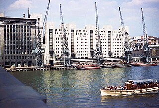
The Port of London is that part of the River Thames in England lying between Teddington Lock and the defined boundary with the North Sea and including any associated docks. Once the largest port in the world, it was the United Kingdom's largest port as of 2020. Usage is largely governed by the Port of London Authority ("PLA"), a public trust established in 1908; while mainly responsible for coordination and enforcement of activities it also has some minor operations of its own.

<span class="mw-page-title-main">St Katharine Docks</span> Human settlement in England

St Katharine Docks is a former dock and now a mixed-used district in Central London, in the London Borough of Tower Hamlets and within the East End. It lies on the north bank of the River Thames, immediately downstream of the Tower of London and Tower Bridge. From 1828 to 1968, it was one of the commercial docks that made up the Port of London. It is in the redevelopment zone known as Docklands and is now a popular housing and leisure complex.

<span class="mw-page-title-main">Billingsgate</span> Ward of the City of London

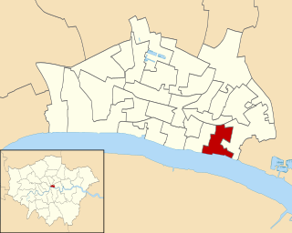
Billingsgate is one of the 25 Wards of the City of London. This small City Ward is situated on the north bank of the River Thames between London Bridge and Tower Bridge in the south-east of the Square Mile.

<span class="mw-page-title-main">Pool of London</span> Area of the Thames

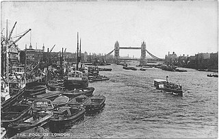
The Pool of London is a stretch of the River Thames from London Bridge to below Limehouse.

<span class="mw-page-title-main">Royal Docks</span> Area in Newham, London

Royal Docks is an area and a ward in the London Borough of Newham in the London Docklands in East London, England.

<span class="mw-page-title-main">Lighterman</span> Worker who manoeuvers a barge

A lighterman is a worker who operates a lighter, a type of flat-bottomed barge, which may be powered or unpowered. In the latter case, it is usually moved by a powered tug. The term is particularly associated with the highly skilled men who operated the unpowered lighters moved by oar and water currents in the Port of London.

<span class="mw-page-title-main">Billingsgate Fish Market</span> Fish market in Poplar in London, England

Billingsgate Fish Market is located in Poplar in London. It is the United Kingdom's largest inland fish market. It takes its name from Billingsgate, a ward in the south-east corner of the City of London, where the riverside market was originally established. In its original location in the 19th century, Billingsgate was the largest fish market in the world.

<span class="mw-page-title-main">Shad Thames</span> Area of Bermondsey in London, England

Shad Thames is a historic riverside street next to Tower Bridge in Bermondsey, London, England, and is also an informal name for the surrounding area. In the 19th century, the area included the largest warehouse complex in London.

<span class="mw-page-title-main">St Mary-at-Hill</span> Church in London

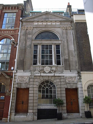
St Mary-at-Hill is a Church of England parish church in the Ward of Billingsgate, City of London. It is situated on Lovat Lane, a cobbled street off Eastcheap.

<span class="mw-page-title-main">St George Botolph Lane</span> Church in London, England

St George Botolph Lane was a church off Eastcheap, in the ward of Billingsgate in the City of London. The rear of the church overlooked Pudding Lane, where the fire of London started. It was first recorded in the twelfth century, and destroyed in the Great Fire of 1666. It was one of the 51 churches rebuilt by the office of Sir Christopher Wren. The church was demolished in 1904.

<span class="mw-page-title-main">St Botolph Billingsgate</span> Church

St Botolph's, Billingsgate was a Church of England parish church in London. Of medieval origin, it was located in the Billingsgate ward of the City of London and destroyed by the Great Fire of London in 1666.

<span class="mw-page-title-main">Dundee Wharf</span>

Dundee Wharf is a residential development in Limehouse in the London Borough of Tower Hamlets in London. The modern buildings occupy the site of a former shipyard known as Limekiln Dockyard. John Graves established this shipyard in 1633 and then expanded his holdings with Dundee Wharf itself. By 1650 George Margetts developed a ropemaking yard including a ropehouse, storehouse and a ropewalk on the site. A modern wharf with electric cranes was constructed in the 1930s. This was used by the Dundee, Perth & London Shipping Company to operate a twice-weekly service between Perth, Dundee, Leith and London.

<span class="mw-page-title-main">Deptford Wharf</span>

<span class="mw-page-title-main">Fresh Wharf</span>

Fresh Wharf was a wharf located in the City of London close to London Bridge, on the north bank of the River Thames. The site was used as a quay in Roman times and later as an unloading place for Anglo-Saxon boats. A wharf was constructed there at some point in the medieval period and appears to have acquired its name from its customary usage as a landing place for fresh fish. In the 16th century, Fresh Wharf was made a "Legal Quay" authorised for the import of certain goods during the reign of Queen Elizabeth I of England. It expanded as London's river-borne trade grew in the 18th and 19th centuries, with large warehouses being established immediately behind the wharf. In the 20th century, the wharf's owners took over the adjoining wharves immediately upstream and downstream, built a new ten-storey warehouse and renamed the site New Fresh Wharf. By the end of the 1960s, however, London's docks had fallen into disuse with the advent of containerization, for which they were not suited, and the wharf was closed down in 1970. An office block was built on the site of the warehouse in 1977 and the former quayside is now part of a public footpath along the Thames.

<span class="mw-page-title-main">Legal Quays</span>

The Legal Quays of England were created by the Act of Frauds, an Act of Parliament enacted in 1559 during the reign of Elizabeth I of England. It established new rules for customs in England in order to boost the Crown's finances. One of its most important provisions was the establishment of a rule that it was illegal to land or load goods anywhere other than authorised Legal Quays in London and other ports, under the supervision of customs officers. The legislation also set out which towns were authorised to act as ports.

<span class="mw-page-title-main">London Bridge Wharf</span>

London Bridge Wharf was a wharf in the City of London located alongside London Bridge, just to the east of the north end of the bridge. It stood below the Adelaide Buildings and their 1925 replacement, Adelaide House. The wharf was constructed on the site of the London Bridge Waterworks, which had been demolished along with Old London Bridge in 1832. It originally handled general cargo and also passenger steamships, such as the vessels of the New Medway Steam Packet Company, which offered daily "sea cruises" along the North Kent and Essex coasts.

Botolph Wharf or St Botolph's Wharf was a wharf located in the City of London, on the north bank of the River Thames a short distance downstream from London Bridge. It was situated between Cox and Hammond's Quay upstream and Nicholson's Wharf downstream. On the landward side, the wharf was accessed via Thames Street. It had a frontage of 78 ft (24 m). The wharf was used for at least a thousand years before being destroyed during the Second World War. A late 1980s office building currently occupies the site.

References

  1. Rule, Fiona (2012). London's Docklands: A History of the Lost Quarter. Ian Allan Publishing. p. 97. ISBN   978-0-7110-3716-8.
  2. James Elmes (1831). A Topographical Dictionary of London and Its Environs: Containing Descriptive and Critical Accounts of All the Public and Private Buildings, Offices, Docks, Squares, Streets, Lanes, Wards, Liberties, Charitable, Scholastic and Other Establishments, with Lists of Their Officers, Patrons, Incumbents of Livings, &c. &c. &c. in the British Metropolis. Whittaker, Treacher and Arnot. p. 269.
  3. Henry A Harben, 'Cousen's Lane – Crachemilles', in A Dictionary of London (London, 1918), https://www.british-history.ac.uk/no-series/dictionary-of-london/cousens-lane-crachemilles#h2-0017 (accessed 16 March 2015).
  4. Henry A Harben, 'Garlickhithe – George (St.) in Pudding Lane', in A Dictionary of London (London, 1918), https://www.british-history.ac.uk/no-series/dictionary-of-london/garlickhithe-george-in-pudding-lane#h2-0013 (accessed 16 March 2015).
  5. Henry A Harben, 'Hall's Rents, St. Katherine's – Hand Alley', in A Dictionary of London (London, 1918), https://www.british-history.ac.uk/no-series/dictionary-of-london/halls-rents-st-katherines-hand-alley#h2-0012 (accessed 16 March 2015).
  6. 1 2 McCusker, John J.; Morgan, Kenneth (2000). The Early Modern Atlantic Economy . Cambridge University Press. p.  81. ISBN   978-0-521-78249-4.
  7. Crawford, Anne (1977). A history of the Vintners' Company . Constable. p.  200.
  8. Crawford, p. 176
  9. 1 2 Report from the Joint Select Committee of the House of Lords and the House of Commons on the Port of London Bill. HMSO. 1903. p. 99.
  10. Great Britain. Parliament. House of Commons (1843). "Orders made by the Commissioners of Customs, 25 October 1842". Parliamentary Papers, House of Commons and Command. H.M. Stationery Office. p. 54.
  11. Loveday, James Thomas (1857). Loveday's London Waterside Surveys: For the Use of Fire Insurance Companies, Showing Wharves and Granaries with the Buildings Connected on the Banks of the Thames from London Bridge to Rotherhithe [and] Tower Dock. The Author. p. 57.
  12. "London Forthcoming Contracts". The Architect and Contract Reporter: 304. 18 December 1869.
  13. Ellmers, Chris; Werner, Alex (2000). London's Riverscape Lost and Found. London's Found Riverscape Partnership. p. 2. ISBN   1-874044-30-9.
  14. London County Council (2005). The London County Council bomb damage maps, 1939–1945. London Topographical Society. ISBN   9780902087514.
  15. 1 2 Ken Steedman; Tony Dyson; John Schofeld; A. G. Vince; Jennifer Hillam (1992). The Bridgehead and Billingsgate to 1200. London & Middlesex Archaeological Society.
  16. Port of London Guide. Coram Publishers. 1957. p. 181.

51°30′32″N0°05′08″W / 51.508909°N 0.085551°W / 51.508909; -0.085551