
A wharf, quay, staith, or staithe is a structure on the shore of a harbour or on the bank of a river or canal where ships may dock to load and unload cargo or passengers. Such a structure includes one or more berths, and may also include piers, warehouses, or other facilities necessary for handling the ships. Wharves are often considered to be a series of docks at which boats are stationed. A marginal wharf is connected to the shore along its full length.

St Katharine Docks is a former dock and now a mixed-used district in Central London, in the London Borough of Tower Hamlets and within the East End. It lies on the north bank of the River Thames, immediately downstream of the Tower of London and Tower Bridge. From 1828 to 1968, it was one of the commercial docks that made up the Port of London. It is in the redevelopment zone known as Docklands and is now a popular housing and leisure complex.

Royal Docks is an area in the London Borough of Newham in the London Docklands in East London, England.

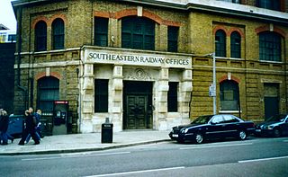
Strood is a town in the unitary authority of Medway in Kent, South East England. The town forms a conurbation with neighbouring towns Chatham, Rochester, Gillingham and Rainham. It lies on the northwest bank of the River Medway at its lowest bridging point.

Butler's Wharf is an English historic building at Shad Thames on the south bank of the River Thames, just east of London's Tower Bridge, now housing luxury flats and restaurants. Lying between Shad Thames and the Thames Path, it overlooks both the bridge and St Katharine Docks on the north side of the river. Butler's Wharf is also used as a term for the surrounding area. It is a Grade II listed building.
Tooley Street is a road in central and south London connecting London Bridge to St Saviour's Dock; it runs past Tower Bridge on the Southwark/Bermondsey side of the River Thames, and forms part of the A200 road.

Shad Thames is a historic riverside street next to Tower Bridge in Bermondsey, London, England, and is also an informal name for the surrounding area. In the 19th century, the area included the largest warehouse complex in London.

Hay's Galleria is a mixed use building in the London Borough of Southwark situated on the south bank of the River Thames featuring offices, restaurants, shops, and flats. Originally a warehouse and associated wharf for the port of London, it was redeveloped in the 1980s. It is a Grade II listed structure.

Jacob's Island was a notorious slum in Bermondsey, London, in the 19th century. It was located on the south bank of the River Thames, approximately delineated by the modern streets of Mill Street, Bermondsey Wall West, George Row and Wolseley Street. Jacob's Island developed a reputation as one of the worst slums in London, and was popularised by the Charles Dickens novel Oliver Twist, published shortly before the area was cleared in the 1860s.
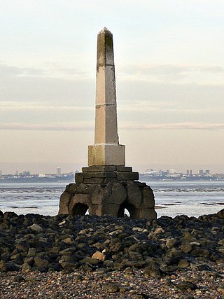
Yantlet Creek is the creek draining into the River Thames that separated the Isle of Grain from the Hoo peninsula. It once connected the River Medway with the River Thames and made the Isle of Grain a true island. The creek silted up and now drains the area of The Isle of Grain and Allhallows Marshes. A monument known as the London Stone is located at its mouth and marks the limit of the City of London's ownership of the Thames.

National Cycle Route 1 is a route of the United Kingdom National Cycle Network, running from Dover to Tain. The 1,264 mi-long (2,034-kilometre) cycle-path is located in the United Kingdom.

Queen Victoria Street, named after the British monarch who reigned from 1837 to 1901, is a street in London that runs east by north from its junction with New Bridge Street and Victoria Embankment in the Castle Baynard ward of the City of London, along a section that divides the wards of Queenhithe and Bread Street, then lastly through the middle of Cordwainer ward, until it reaches Mansion House Street at Bank junction. Beyond Bank junction, the street continues north-east as Threadneedle Street which joins Bishopsgate. Other streets linked to Queen Victoria Street include Puddle Dock, Cannon Street, Walbrook and Poultry.
The Medway and its tributaries and sub-tributaries have been used for over 1,150 years as a source of power. There are over two hundred sites where the use of water power is known. These uses included corn milling, fulling, paper making, iron smelting, pumping water, making gunpowder, vegetable oil extraction, and electricity generation. Today, there is just one watermill working for trade. Those that remain have mostly been converted. Such conversions include a garage, dwellings, restaurants, museums and a wedding venue. Some watermills are mere derelict shells, lower walls or lesser remains. Of the majority, there is nothing to be seen.

Park End Street is a street in central Oxford, England, to the west of the centre of the city, close to the railway station at its western end.

Dundee Wharf is a residential development in Limehouse in the London Borough of Tower Hamlets in London. The modern buildings occupy the site of a former shipyard known as Limekiln Dockyard. John Graves established this shipyard in 1633 and then expanded his holdings with Dundee Wharf itself. By 1650 George Margetts developed a ropemaking yard including a ropehouse, storehouse and a ropewalk on the site. A modern wharf with electric cranes was constructed in the 1930s. This was used by the Dundee, Perth & London Shipping Company to operate a twice-weekly service between Perth, Dundee, Leith and London.

Deptford Wharf in London, United Kingdom, is on the Thames Path southeast of South Dock Marina, across the culverted mouth of the Earl's Sluice and north of Aragon Tower. In the late 18th and early 19th century this area was used for shipbuilding with several building slips. With the coming of the railway in 1848 Deptford wharf and docks were used to import coal and for other goods. The housing here, completed in 1992, is on the site of former railway sidings and riverside wharves.
Fresh Wharf was a wharf located in the City of London close to London Bridge, on the north bank of the River Thames. The site was used as a quay in Roman times and later as an unloading place for Anglo-Saxon boats. A wharf was constructed there at some point in the medieval period and appears to have acquired its name from its customary usage as a landing place for fresh fish. In the 16th century, Fresh Wharf was made a "Legal Quay" authorised for the import of certain goods during the reign of Queen Elizabeth I of England. It expanded as London's river-borne trade grew in the 18th and 19th centuries, with large warehouses being established immediately behind the wharf. In the 20th century, the wharf's owners took over the adjoining wharves immediately upstream and downstream, built a new ten-storey warehouse and renamed the site New Fresh Wharf. By the end of the 1960s, however, London's docks had fallen into disuse with the advent of containerization, for which they were not suited, and the wharf was closed down in 1970. An office block was built on the site of the warehouse in 1977 and the former quayside is now part of a public footpath along the Thames.

Cox & Hammond's Quay was a wharf located in the City of London, on the north bank of the River Thames a short distance downstream from London Bridge. It was originally two separate quays, Cox's Quay and Hammond's Quay, separated by Gaunt's Quay. On the landward side, the wharf was accessed via Lower Thames Street just behind the site of the church of St Botolph Billingsgate.
Botolph Wharf or St Botolph's Wharf was a wharf located in the City of London, on the north bank of the River Thames a short distance downstream from London Bridge. It was situated between Cox and Hammond's Quay upstream and Nicholson's Wharf downstream. On the landward side, the wharf was accessed via Thames Street. It had a frontage of 78 ft (24 m). The wharf was used for at least a thousand years before being destroyed during the Second World War. A late 1980s office building currently occupies the site.
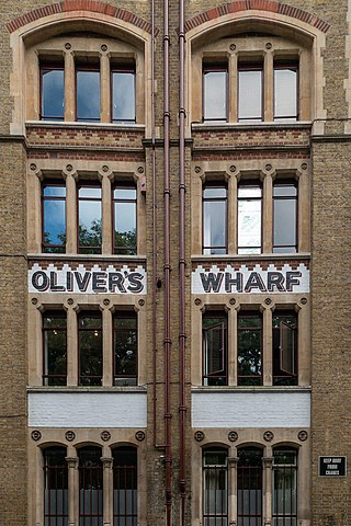
Oliver's Wharf is a Grade II listed apartment building and former warehouse on the River Thames in Wapping High Street, Wapping, London.
