
The Brecon Beacons, or Bannau Brycheiniog is a mountainous region, national park and mountain range in Wales.

Trecastle is a village in Powys, Wales, situated on the edge of the Brecon Beacons National Park (Welsh: Parc Cenedlaethol Bannau Brycheiniog) and in the community of Llywel. The village has a population of about 200.
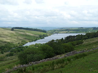
Crai Reservoir is a storage reservoir located in the Brecon Beacons National Park for the water supply to the city of Swansea in South Wales and was built between 1898 and 1908 by Swansea Corporation.
Llanddeusant is a community in the Black Mountain Range of the Brecon Beacons National Park in Carmarthenshire, Wales. It is about 5 miles southeast of Llangadog.

Llywel is a small village located on the A40, about 4 miles (6.4 km) west of Sennybridge in Brecknockshire, Wales. The Afon Gwydderig runs through the village, not far from its source. Llywel also gives its name to a community. The main settlement in the community is Trecastle. According to the 2001 Census the population of Llywel community is 524, falling to 497 at the 2011 Census.

Fforest Fawr is an extensive upland area in the county of Powys, Wales. Formerly known as the Great Forest of Brecknock in English, it was a royal hunting area for several centuries but is now used primarily for sheep grazing, forestry, water catchment and recreation. It lies within the Brecon Beacons National Park.

The Afon Crai is a river in Powys, Wales rising in the Fforest Fawr section of the Brecon Beacons National Park and flowing north into the River Usk. The headwaters known as Blaen-crai flow north from Bwlch Bryn-rhudd, a col between the Crai valley and the upper Swansea Valley for 2 km into the Cray Reservoir. The river emerges from below the dam to flow a further 8 km through the dispersed settlement of Crai.
Heol Senni is a hamlet in the valley of the Afon Senni just north of the Fforest Fawr section of the Brecon Beacons National Park. It lies within the community of Maescar in the county of Powys, Wales. The Welsh name means the 'road by Senni' and reflects its position near the crossing of the river by the minor road running from the A4067 to the A4215 road. This route was, and to some extent still is, an important link between Brecon and the upper Swansea Valley.
Cefn Cul is a hill in the Fforest Fawr sector of the Brecon Beacons National Park in Powys, southern Wales. It is a broad north-northeast to south-southwest aligned ridge whose summit reaches a height of 562 m above sea level. The hill is bounded to the west by the upper valley of the River Tawe though which the old Trecastle road runs whilst to the east is the pass of Bwlch Bryn-rhudd over which the A4067 road runs from the Crai valley south to that of the Tawe.

Glasfynydd Forest is an extensive area of coniferous plantations in the west of the Brecon Beacons National Park in Wales. It straddles the border between the counties of Powys and Carmarthenshire.

Llangattock is a village, community and electoral ward in the Brecon Beacons National Park in Powys, Wales. It lies in the Usk Valley just across the river from the town of Crickhowell. The Monmouthshire and Brecon Canal passes through the village en route between Brecon and Pontypool. It is in the historic county of Breconshire.

Libanus is a village in the Brecon Beacons National Park, Powys, Wales, United Kingdom, and in the community of Glyn Tarell. Presumably, the name of the village derives from Mount Lebanon, also known as the Lebanon Mountains, the ancient name for which was Libanus, a common name for chapels in Wales.

Pontsticill is a village within the county borough of Merthyr Tydfil in South Wales. It lies within the valley of the Taf Fechan on the southern edge of the Brecon Beacons National Park. The village lies within the community of Vaynor in an area that was, until the local government re-organisation of 1974, within the historic county of Brecknockshire.

Llanspyddid is a small village just west of Brecon within the Brecon Beacons National Park. It lies within the valley of the River Usk in the community of Glyn Tarell in the county of Powys, Wales. Llanspyddid sits on the A40 trunk road between Brecon and Llandovery. The Welsh name signifies the 'church of Saint Ysbyddyd', though the village church is in fact dedicated to Saint Cadog.

Llanfrynach is a village and community in the county of Powys, Wales, and the historic county of Brecknockshire. The population of the community as taken at the 2011 census was 571. It lies just to the southeast of Brecon in the Brecon Beacons National Park. The village sits astride the Nant Menasgin, a right bank tributary of the River Usk. The B4558 passes just to its north and the Monmouthshire and Brecon Canal also passes around the village. The Welsh name signifies the 'church of Brynach'. The community includes the hamlets of Llanhamlach and Groesffordd.

Tawe-Uchaf is a community in Powys, Wales. Situated north-east of Ystradgynlais in the upper valley of the River Tawe, it includes the villages of Caehopkin, Coelbren, Glyntawe, Pen-y-cae, Penwyllt and Ynyswen. It had a population in 2001 of 1,516, increasing at the 2011 Census to 1,562.
Crai is a community including the village of Crai and the hamlet of Felin-Crai in Breconshire, Powys, Wales. The population was 241 as of the 2011 UK Census. It also includes the Crai reservoir and is mostly in the Brecon Beacons National Park.

Llanwrtyd Wells is the name of an electoral ward in mid Powys, Wales. It covers three local government communities and elects a councillor to Powys County Council.
Pencelli is a small village within the community of Talybont-on-Usk in the county of Powys, Wales, and the historic county of Brecknockshire. The Welsh name signifies the 'end of (a) grove'. It lies just to the southeast of Brecon in the Brecon Beacons National Park. The village sits near the confluence of the Nant Menasgin with the River Usk. Both the B4558 and the Monmouthshire and Brecon Canal pass through the village. There is a pub - the Royal Oak, an outdoor education centre and a campsite within the village. Pencelli Castle is likely a late eleventh century fortification which fell into disuse in the thirteenth century.
Groesffordd is a small village within the community of Llanfrynach in the county of Powys, Wales, and the historic county of Brecknockshire. The Welsh name signifies the 'crossroads'. It lies just to the east of Brecon straddling the northern boundary of the Brecon Beacons National Park. The village sits just to the north of the A40 road between Brecon and Crickhowell and north of the River Usk and Monmouthshire and Brecon Canal. The track of the former Brecon and Merthyr Railway runs through the village

