Craney Island (Virginia)

Last updated
Craney Island
Craney.jpg
Craney Island Blockhouse during the War of 1812 [1]
USA Virginia location map.svg
Red pog.svg
Craney Island
Usa edcp location map.svg
Red pog.svg
Craney Island
Geography
Location Elizabeth River
Coordinates 36°53′33″N76°21′34″W / 36.89250°N 76.35944°W / 36.89250; -76.35944
Total islands1
Administration
United States
State Virginia
City City of Portsmouth
Demographics
Populationnone
Craney Island Fort
Craney Island, Portsmouth (formerly Norfolk County), Virginia
Type Earthwork fort
Site information
Controlled byU.S. Army Corps of Engineers
ConditionNo remains
Site history
Built1813, 1862
Built by United States Army Corps of Engineers
Confederate forces
In use1813–1820, 1862
MaterialsEarth
Battles/wars War of 1812
American Civil War
Map of the Battle of Craney Island Battle of Craney Island.jpg
Map of the Battle of Craney Island
Craney Island Light; this structure stood 1884-1936 Craney Island Light.PNG
Craney Island Light; this structure stood 1884–1936

Craney Island is a point of land in the independent city of Portsmouth in the South Hampton Roads region of eastern Virginia in the United States. The location, formerly in Norfolk County, is near the mouth of the Elizabeth River opposite Lambert's Point on Hampton Roads. It is home to the Craney Island US Naval Supply Center, managed by the U.S. Army Corps of Engineers.

Contents

History

The name "Craney Island" was derived from the fact that the early English settlers on the Elizabeth River in the 17th century were impressed with the great number of what they mistakenly believed to be cranes that inhabited it. Hence the name "Crayne" or "Craney Point." The birds the settlers thought were cranes were actually white and blue herons, still fairly common birds in the Hampton Roads region.[ citation needed ]

Near the entrance to the navigational channel of the Elizabeth River, Craney Island proved to be of strategic significance during the War of 1812 and the American Civil War.

War of 1812

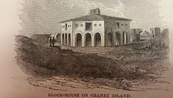
During the War of 1812, the federal government built the Craney Island Fort as part of the second system of US fortifications. It was completed in early 1813. The fort had a mile-long earthwork connecting the main seven-gun battery in the southeast with an outer battery and blockhouse in the northwest. A small redoubt was in the fort's center. [2] By June 1813 the fort was armed with two 24-pounder cannon, along with one 18-pounder and four 6-pounders. [3]

On June 22, 1813, the Battle of Craney Island took place. During the battle, the fort was manned by 580 Regulars and militia in addition to 150 sailors and marines from the USS Constellation, all under Brigadier General Robert B. Taylor. [3] 81 British troops were killed, wounded or captured of their 2,500-man force in total, with no American losses of their 730-man force. The victory at Craney Island saved Norfolk and Portsmouth from being captured and pillaged by the enemy during the war. However, the British proceeded to burn the nearby city of Hampton, Virginia, which had no forts at the time. [4]

The repulse at Craney Island did not deter the British from further operations in Hampton Roads the next year. In 1814, they proceeded up Chesapeake Bay to burn Washington, D.C., and unsuccessfully attack Baltimore, as there were no forts guarding the mouth of the bay at the time. This led to the building of Fort Monroe beginning in the 1820s, to close the bay to enemy vessels.[ citation needed ]

The fort was abandoned at some time after 1820. [3]

First U.S. Lightship, lighthouses

In 1820, the first U.S. lightship was established at Hampton Roads. It was first placed at Willoughby Spit, on the south side of the harbor. The weather conditions proved to be too harsh on the seventy-ton vessel there and it was moved to Craney Island where it served until 1859. It was replaced by a lighthouse, which was replaced in 1884 by a hexagonal screwpile lighthouse. The 1884 Craney Island Light served until 1936, when it was replaced by an automated light on the old foundation. [5] In the 1970s this was replaced by a buoy.

Civil War

Early in the American Civil War (1861–1865), the important Gosport Shipyard upstream from Craney Island on the Elizabeth River at Portsmouth fell into Confederate hands and the first Confederate ironclad warship CSS Virginia was converted from USS Merrimack there. The Confederates built a 20-gun battery on the island and berthed the Virginia there. [2] This ship fought the first Union ironclad USS Monitor during the famous Battle of Hampton Roads on March 9, 1862, which was inconclusive as neither armored ship could defeat the other.

Only two months later, as recapture of Norfolk and Portsmouth by Union forces was imminent, on the morning of May 11, 1862, the Virginia was deliberately run aground near Craney Island and burned by the crew to avoid capture. [6]

Modern times

In modern times, Craney Island is an industrial area and has been used as a location for placement of dredged materials since 1957. [2] It is operated by the U.S. Army Corps of Engineers. A major fueling depot for the United States Navy is located adjacent. The Norfolk District of the Corps staff has received recognition for the creation, protection, and preservation of a critical habitat for birds such as the piping plover, least terns, brown pelicans, osprey, and other threatened or endangered species that use the island as a large nesting ground. Audubon Society members have turned the island into a favorite spot for bird watching.[ citation needed ]

Craney Island is visible to Interstate 664 traffic crossing Hampton Roads on the Monitor–Merrimac Memorial Bridge–Tunnel, which is west of the island. It may also be viewed from Old Dominion University, which is east of the island across the Elizabeth River. The proposed "Third Crossing" of Hampton Roads would cross Craney Island.

Although not a historical name for the ship or station, a lightship named Portsmouth commemorates the first lightship at Craney Island at the Portsmouth Naval Shipyard Museum in Portsmouth, Virginia. [7]

Virginia Historical Marker K-258 (The Battle of Craney Island) (at the entrance to Hoffler Creek Wildlife Preserve on Twin Pines Road) commemorates the battle. [2] [8]

Related Research Articles

CSS <i>Virginia</i> Civil War Confederate ironclad

CSS Virginia was the first steam-powered ironclad warship built by the Confederate States Navy during the first year of the American Civil War; she was constructed as a casemate ironclad using the razéed original lower hull and engines of the scuttled steam frigate USS Merrimack. Virginia was one of the participants in the Battle of Hampton Roads, opposing the Union's USS Monitor in March 1862. The battle is chiefly significant in naval history as the first battle between ironclads.

USS <i>Monitor</i> First ironclad of the US Navy, 1861–1862

USS Monitor was an ironclad warship built for the United States Navy during the American Civil War and completed in early 1862, the first such ship commissioned by the Navy. Monitor played a central role in the Battle of Hampton Roads on 9 March under the command of Lieutenant John L. Worden, where she fought the casemate ironclad CSS Virginia to a stalemate. The design of the ship was distinguished by its revolving turret, which was designed by American inventor Theodore Timby; it was quickly duplicated and established the monitor class and type of armored warship built for the American Navy over the next several decades.

<span class="mw-page-title-main">Norfolk Naval Shipyard</span> American Navy Shipyard

The Norfolk Naval Shipyard, often called the Norfolk Navy Yard and abbreviated as NNSY, is a U.S. Navy facility in Portsmouth, Virginia, for building, remodeling and repairing the Navy's ships. It is the oldest and largest industrial facility that belongs to the U.S. Navy as well as the most comprehensive. Located on the Elizabeth River, the yard is just a short distance upriver from its mouth at Hampton Roads.

<span class="mw-page-title-main">Battle of Hampton Roads</span> 1862 naval battle in the American Civil War, the first between ironclads

The Battle of Hampton Roads, also referred to as the Battle of the Monitor and Merrimack or the Battle of Ironclads, was a naval battle during the American Civil War.

USS <i>Minnesota</i> (1855) Gunboat of the United States Navy

USS Minnesota was a wooden steam frigate in the United States Navy. Launched in 1855 and commissioned eighteen months later, the ship served in east Asia for two years before being decommissioned. She was recommissioned at the outbreak of the American Civil War and returned to service as the flagship of the North Atlantic Blockading Squadron.

<span class="mw-page-title-main">Fort Wool</span> Historic island fortification in Virginia

Fort Wool is a decommissioned island fortification located in the mouth of Hampton Roads, adjacent to the Hampton Roads Bridge-Tunnel (HRBT). Officially known as Rip Raps Island, the fort has an elevation of 7 feet and sits near Old Point Comfort, Old Point Comfort Light, Willoughby Beach and Willoughby Spit, approximately one mile south of Fort Monroe.

<span class="mw-page-title-main">John L. Porter</span> American naval constructor

John Luke Porter was a naval constructor for United States Navy and the Confederate States Navy.

USS <i>Merrimack</i> (1855) U.S. Navy Steam frigate

USS Merrimack, also improperly Merrimac, was a steam frigate, best known as the hull upon which the ironclad warship CSS Virginia was constructed during the American Civil War. The CSS Virginia then took part in the Battle of Hampton Roads in the first engagement between ironclad warships.

<span class="mw-page-title-main">William A. Webb</span>

William Augustin Webb was an American sailor and Mexican–American War veteran who resigned his United States Navy commission after more than 20 years of service to join the Confederate States Navy in the American Civil War. Webb was decorated for his service as Captain of the CSS Teaser, part of the James River Squadron, during the Battle of Hampton Roads (1862).

<span class="mw-page-title-main">Battle of Drewry's Bluff</span> Battle of the American Civil War

The Battle of Drewry's Bluff, also known as the Battle of Fort Darling, or Fort Drewry, took place on May 15, 1862, in Chesterfield County, Virginia, as part of the Peninsula Campaign of the American Civil War. Four Union Navy warships, including the ironclads USS Monitor and Galena, and the United States Revenue Cutter Service's ironclad USRC Naugatuck steamed up the James River to test the defenses of Richmond, Virginia, the Confederate capital. They encountered submerged obstacles, and deadly accurate fire from the batteries of Fort Darling at Drewry's Bluff, which inflicted severe damage on Galena, forcing them to turn back.

The Battle of Sewell's Point was an inconclusive exchange of cannon fire between the Union gunboat USS Monticello, supported by the USS Thomas Freeborn, and Confederate batteries on Sewell's Point that took place on May 18, 19 and 21, 1861, in Norfolk County, Virginia in the early days of the American Civil War. Little damage was done to either side. By the end of April 1861, USS Cumberland and a small number of supporting ships were enforcing the Union blockade of the southeastern Virginia ports at the southern end of the Chesapeake Bay and had captured several ships which attempted to pass the blockade. USS Monticello's bombardment of the Sewell's Point battery was one of the earliest Union Navy actions against Confederate forces during the Civil War. While it has been suggested by some sources that the Monticello's action may have been the first gunfire by the Union Navy during the Civil War, a brief exchange of cannon fire between the U.S. gunboat USS Yankee and shore batteries manned by Virginia volunteer forces which had not yet been incorporated into the Confederate States Army at Gloucester Point, Virginia on the York River occurred on May 7, 1861.

USS <i>St. Lawrence</i> Frigate of the United States Navy, launched 1848

USS St. Lawrence was a frigate in the United States Navy that saw service during the mid-19th century, including the American Civil War. She was based on the same plans as USS Brandywine.

<span class="mw-page-title-main">Battle of Craney Island</span>

The Battle of Craney Island was a victory for the United States during the War of 1812. The battle saved the city of Norfolk, and the adjacent city of Portsmouth, from British invasion. Especially important to Virginia and northeastern North Carolina, the region was a major hub for American commerce.

USS Zouave was a steamer acquired by the Union Navy during the American Civil War. She was needed by the Navy to be part of the fleet of ships to prevent blockade runners from entering ports in the Confederacy.

USRC <i>Naugatuck</i> Revenue cutter of the United States

USRC Naugatuck was a twin-screw ironclad experimental steamer operated by the U.S. Revenue Cutter Service during the American Civil War. She served the U.S. Treasury Department as the USRC E.A. Stevens, a name she retained until sold in 1890. She was loaned to the Navy by the Treasury Department and thus mistakenly referred to in U.S. Navy dispatches during early 1862 as "USS Naugatuck".

<span class="mw-page-title-main">Craney Island Light</span> Lighthouse in Virginia, United States

The Craney Island Light was a screwpile lighthouse located just east of Craney Island at the mouth of the Elizabeth River in Virginia. This light replaced the first permanently stationed lightship in the United States.

<span class="mw-page-title-main">History of Hampton Roads</span>

The history of Hampton Roads dates to 1607, when Jamestown was founded. Two wars have taken place in addition to many other historical events.

<span class="mw-page-title-main">Charles Stewart McCauley</span>

Charles Stewart McCauley was an American naval officer in the War of 1812 and the Civil War.

<span class="mw-page-title-main">Fort Norfolk (Norfolk, Virginia)</span>

Fort Norfolk is a historic fort and national historic district located at Norfolk, Virginia. With the original buildings having been built between 1795 and 1809, the fort encloses 11 buildings: main gate, guardhouse, officers' quarters, powder magazine, and carpenter's shop. Fort Norfolk is the last remaining fortification of President George Washington's 18th century harbor defenses, later termed the first system of US fortifications. It has served as the district office for the U.S. Army Engineer District, Norfolk since 1923.

<span class="mw-page-title-main">Fort Nelson (Virginia)</span>

Fort Nelson was a fort located on Hospital Point in Portsmouth, Virginia, which is currently the site of the Portsmouth Naval Hospital. The fort was named for Thomas Nelson Jr., governor of Virginia in 1781. It and Fort Norfolk were built to guard the Elizabeth River, including the cities of Norfolk and Portsmouth and the Gosport Navy Yard. The fort was originally built by patriot forces with funding from the Virginia government in 1776 during the American Revolutionary War, but destroyed when the British occupied the area in 1779. A British map shows that they rebuilt the fort by 1781. Following the Revolution, the fort was again rebuilt in 1794 under the first system of US fortifications, was garrisoned in the War of 1812, but was demolished in 1827 to make room for the naval hospital. The fort was again rebuilt by Confederate forces in 1861, but the Confederates evacuated the area in May 1862 and the fort was eventually demolished.

References

  1. Lossing, Benson (1868). The Pictorial Field-Book of the War of 1812. Harper & Brothers, Publishers. p.  686. ISBN   9780665291364.
  2. 1 2 3 4 Craney Island Fort at American Forts Network
  3. 1 2 3 Craney Island Fort at FortWiki.com
  4. Flanders, Alan (October 1, 1995). "Craney Island Battle Led to Burning of Hampton". The Virginian-Pilot . Archived from the original on April 15, 2008. Retrieved February 19, 2008.
  5. Craney Island Light, from the Chesapeake Chapter of the United States Lighthouse Society
  6. Nelson, J. L. (2007). Reign of Iron: The Story of the First Battling Ironclads, the Monitor and the Merrimack. HarperCollins. pp. 316–320. ISBN   9780061365119.
  7. Foster, Kevin J. (5 August 1988). "National Register of Historic Places Registration Form / Lightship No. 101" (pdf). National Park Service . Retrieved 2012-09-08.
  8. Historic markers at vcris.dhr.virginia.gov