Related Research Articles

Hartwell is a city in Hart County, Georgia, United States. The population was 4,469 at the 2010 census. The city is the county seat of Hart County.

Cranfield University is a British postgraduate public research university specialising in science, engineering, design, technology and management. Cranfield was founded as the College of Aeronautics (CoA) in 1946. Through the 1950s and 1960s, the development of aircraft research led to growth and diversification into other areas such as manufacturing and management, and in 1967, to the founding of the Cranfield School of Management. In 1969, the College of Aeronautics was renamed the Cranfield Institute of Technology, was incorporated by royal charter, gained degree awarding powers, and became a university. In 1993, it adopted its current name.

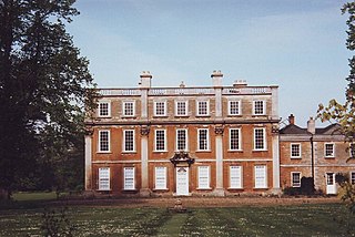
Houghton House is a ruined mansion house in the parish of Houghton Conquest, Bedfordshire. It is a Grade I listed building, positioned above the surrounding countryside, and commands excellent views. Built from 1615 to 1621, it is said that the house was the model for House Beautiful in John Bunyan's The Pilgrim's Progress (1678). It was abandoned in 1794 and stripped of its interiors and roof for sale as building supplies. Today the property is owned by English Heritage, and is open to free public access during daylight hours.
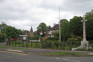
Cranfield is a village and civil parish in the west of Bedfordshire, England, situated between Bedford and Milton Keynes. It had a population of 4,909 in 2001. increasing to 5,369 at the 2011 Census. The parish is in Central Bedfordshire unitary authority. It is best known for being the home of Cranfield University and Cranfield Airport.
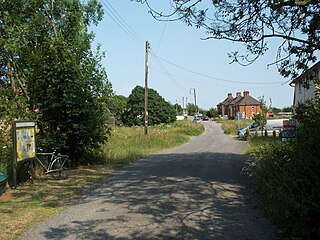
Cockayne Hatley is a small, rural village in the Central Bedfordshire district of the county of Bedfordshire, England 13 miles (21 km) east of the county town of Bedford. The population in 2007 was approximately 75 with 33 houses. It is in the civil parish of Wrestlingworth and Cockayne Hatley.

Mid Bedfordshire is a constituency represented in the House of Commons of the UK Parliament since 2005 by Nadine Dorries, of the Conservative Party. Apart from four early years, the constituency has returned a Conservative since its creation in 1918.

Blunham is a village and civil parish in the Central Bedfordshire district of Bedfordshire, England, about 8 miles (13 km) east of Bedford. At the 2011 census date its population was 946. The River Ivel forms the parish's eastern boundary in places and the River Great Ouse its western and northern boundaries. The village is just over 0.6 miles (1 km) to the west of the A1 road, and Route 51 of the National Cycle Network passes to the south.

Silsoe is a village and civil parish in Bedfordshire, England. The village used to be on the main A6 road but a bypass around the village was opened in 1981 at a cost of £1.6m.
Cranfield United Football Club is a football club based in Cranfield, near Bedford, Bedfordshire, England. The club is affiliated to the Bedfordshire County Football Association. They are currently members of the Bedfordshire County Football League Premier Division.
Hinwick House is a Grade I-listed Queen Anne country house located about 90 minutes from Central London, near Podington in North Bedfordshire. The estate consists of the Queen Anne main house, the Victorian wing, the Victorian wing extension, garage block, stables, three cottages attached to a clock tower, a walled garden and a period dovecote. The house and estate has a total of 50 rooms. Hinwick House underwent a two-year restoration programme that concluded in 2016.

Shuttleworth College is a further education college in the village of Old Warden in Bedfordshire, England. The college is part of Bedford College, and mainly offers courses and training related to agriculture and the natural environment.
Bletsoe Castle was a late medieval fortified manor house in the village of Bletsoe, Bedfordshire.

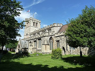
Church of St Peter & St Paul is a Grade I listed church in Cranfield, Bedfordshire, England. It became a listed building on 23 January 1961.

Church of St Mary the Virgin is a Grade I listed church in Henlow, Bedfordshire, England. It became a listed building on 31 October 1966. The original footprint of the church dates back to the 12th century, but the current building dates mostly from the 15th century. The church is mostly in a Perpendicular style, with a myriad of monuments and stained glass windows and a three-stage tower, which was added in the 15th century. The tower housed five bells, which were cast in 1628. Although the number of bells was increased to eight in the 20th century, the nearby house still retains its name of The Five Bells.
The Church of All Saints, formerly The Church of St. Michael, is a medieval building and an active Anglican parish church in Houghton Regis in the English county of Bedfordshire. It is a 13th century Grade I listed building.
Ballymoyer House, now demolished, was an 18th-century country house which stood in a 7000-acre demesne in the townland of Ballintemple, some 5 km north east of Newtownhamilton, County Armagh, Northern Ireland.

Turvey was a railway station on the Bedford to Northampton Line which served the village of Turvey from 1872 to 1962.

Southill Park contains the site of late medieval Gastlings or Gastlyns Manor House and is the name given to a country house in Southill, Bedfordshire and its adjoining privately owned gardens and separate public parkland; it includes a lake and woodland. Its focal point is an early Georgian house, for disambiguation known as Southill Park House which is a heritage-listed building in the highest category. The parkland has legal designations in heritage and plant or wildlife protection. Further structures in the grounds have heritage protection including the follies of a Tuscan architecture temple and a partially stone-faced bridge, both designed by Henry Holland.

Marston Thrift is a 37.4-hectare (92-acre) biological Site of Special Scientific Interest between Marston Moretaine and Cranfield in Bedfordshire. It was notified in 1984 under Section 28 of the Wildlife and Countryside Act 1981, and the local planning authority is Central Bedfordshire Council. It is also a Local Nature Reserve, which extends to a larger area of 55.8 hectares.
James Francis Hatfield Harter was an English landowner and administrator.
References
- ↑ Bedfordshire Churches in the Nineteenth Century: Parishes Harlington to Roxton. Bedfordshire Historical Record. 1994. p. 221. ISBN 978-0-85155-056-5.
- ↑ Page, William (1912). The Victoria History of the County of Bedford. A. Constable. p. 276. ISBN 978-0-7129-0534-3.
- ↑ Walford's County Families of the United Kingdom. 1913. p. 547.
- ↑ Bedfordshire Historic Buildings: The Heritage and Its Problems Today. Bedfordshire County Council. 1975. p. 18.
Coordinates: 52°03′40″N0°36′31″W / 52.0610°N 0.6086°W
| | This article about a Bedfordshire building or structure is a stub. You can help Wikipedia by expanding it. |