A caldera is a large cauldron-like hollow that forms shortly after the emptying of a magma chamber in a volcanic eruption. An eruption that ejects large volumes of magma over a short period of time can cause significant detriment to the structural integrity of such a chamber, greatly diminishing its capacity to support its own roof, and any substrate or rock resting above. The ground surface then collapses into the emptied or partially emptied magma chamber, leaving a large depression at the surface. Although sometimes described as a crater, the feature is actually a type of sinkhole, as it is formed through subsidence and collapse rather than an explosion or impact. Compared to the thousands of volcanic eruptions that occur over the course of a century, the formation of a caldera is a rare event, occurring only a few times within a given window of 100 years. Only eight caldera-forming collapses are known to have occurred between 1911 and 2018, with a caldera collapse at Kīlauea, Hawaii in 2018. Volcanoes that have formed a caldera are sometimes described as "caldera volcanoes".

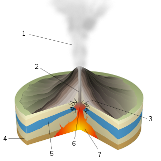
A volcano is a rupture in the crust of a planetary-mass object, such as Earth, that allows hot lava, volcanic ash, and gases to escape from a magma chamber below the surface. The process that forms volcanoes is called volcanism.

Popocatépetl is an active stratovolcano located in the states of Puebla, Morelos, and Mexico in central Mexico. It lies in the eastern half of the Trans-Mexican Volcanic Belt. At 5,393 m (17,694 ft) it is the second highest peak in Mexico, after Citlaltépetl at 5,636 m (18,491 ft).

Nevado del Ruiz, also known as La Mesa de Herveo is a volcano on the border of the departments of Caldas and Tolima in Colombia, being the highest point of both. It is located about 130 km (81 mi) west of the capital city Bogotá. It is a stratovolcano composed of many layers of lava alternating with hardened volcanic ash and other pyroclastic rocks. Volcanic activity at Nevado del Ruiz began about two million years ago, during the Early Pleistocene or Late Pliocene, with three major eruptive periods. The current volcanic cone formed during the present eruptive period, which began 150,000 years ago.

The Mono–Inyo Craters are a volcanic chain of craters, domes and lava flows in Mono County, Eastern California. The chain stretches 25 miles (40 km) from the northwest shore of Mono Lake to the south of Mammoth Mountain. The Mono Lake Volcanic Field forms the northernmost part of the chain and consists of two volcanic islands in the lake and one cinder cone volcano on its northwest shore. Most of the Mono Craters, which make up the bulk of the northern part of the Mono–Inyo chain, are phreatic volcanoes that have since been either plugged or over-topped by rhyolite domes and lava flows. The Inyo volcanic chain form much of the southern part of the chain and consist of phreatic explosion pits, and rhyolitic lava flows and domes. The southernmost part of the chain consists of fumaroles and explosion pits on Mammoth Mountain and a set of cinder cones south of the mountain; the latter are called the Red Cones.
A phreatic eruption, also called a phreatic explosion, ultravulcanian eruption or steam-blast eruption, occurs when magma heats ground water or surface water. The extreme temperature of the magma causes near-instantaneous evaporation of water to steam, resulting in an explosion of steam, water, ash, rock, and volcanic bombs. At Mount St. Helens in Washington state, hundreds of steam explosions preceded the 1980 Plinian eruption of the volcano. A less intense geothermal event may result in a mud volcano.
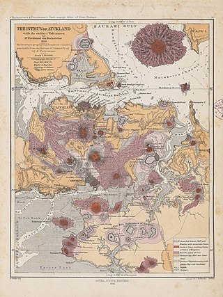
The Auckland volcanic field is an area of monogenetic volcanoes covered by much of the metropolitan area of Auckland, New Zealand's largest city, located in the North Island. The approximately 53 volcanoes in the field have produced a diverse array of maars, tuff rings, scoria cones, and lava flows. With the exception of Rangitoto, no volcano has erupted more than once, but the other eruptions lasted for various periods ranging from a few weeks to several years. Rangitoto erupted several times and recently twice; in an eruption that occurred about 600 years ago, followed by a second eruption approximately 50 years later. The field is fuelled entirely by basaltic magma, unlike the explosive subduction-driven volcanism in the central North Island, such as at Mount Ruapehu and Lake Taupō.

A maar is a broad, low-relief volcanic crater caused by a phreatomagmatic eruption. A maar characteristically fills with water to form a relatively shallow crater lake, which may also be called a maar.

Shishaldin Volcano, or Mount Shishaldin, is one of six active volcanoes on Unimak Island in eastern the Aleutian Islands of Alaska. It is the highest mountain peak of the Aleutian Islands, rising to a height of 9,373 ft above sea level. Shishaldin's magma supply is generated via flux melting above the Aleutian Trench, where the Pacific Plate subducts beneath the North American Plate. Due to its remote location and frequently inclement weather, the Alaska Volcano Observatory (AVO) monitors the volcano remotely via satellite and a seismic network deployed in 1997. Shishaldin is one of the most active volcanoes in the Aleutian Islands, with 40 confirmed eruptions in the last 11,700 years. Notably, Shishaldin produced a sub-Plinian eruption in 1999.
Tower Hill is an inactive volcano on the south-west coast of Victoria, Australia, approximately 275 kilometres (171 mi) west of Melbourne, and 15 kilometres (9 mi) north-west of Warrnambool. The Tower Hill crater is roughly 3 kilometres (2 mi) wide and 80 metres (260 ft) high, with a gradient of between 10% and 80% at the higher points. Within the crater, a series of later volcanic explosions formed a number of scoria cones and spheres, surrounded by a crater lake. Being a giant nested maar, Tower Hill is of international geological significance. The Dhauwurdwurrung name for the volcano is Koroitj.

Lascar is a stratovolcano in Chile within the Central Volcanic Zone of the Andes, a volcanic arc that spans Peru, Bolivia, Argentina and Chile. It is the most active volcano in the region, with records of eruptions going back to 1848. It is composed of two separate cones with several summit craters. The westernmost crater of the eastern cone is presently active. Volcanic activity is characterized by constant release of volcanic gas and occasional vulcanian eruptions.

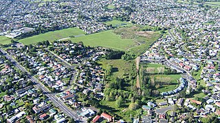
The Panmure Basin, also sometimes known as the Panmure Lagoon, is a tidal estuary within a volcanic crater or maar in New Zealand's Auckland volcanic field. It is located to the south of Panmure town centre.
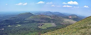
The Chaîne des Puys is a north-south oriented chain of cinder cones, lava domes, and maars in the Massif Central of France. The chain is about 40 km (25 mi) long, and the identified volcanic features, which constitute a volcanic field, include 48 cinder cones, eight lava domes, and 15 maars and explosion craters. Its highest point is the lava dome of Puy de Dôme, located near the middle of the chain, which is 1,465 m (4,806 ft) high. The name of the range comes from a French term, puy, which refers to a volcanic mountain with a rounded profile. A date of 4040 BC is usually given for the last eruption of a Chaîne des Puys volcano.

Halemaʻumaʻu is a pit crater within the much larger Kīlauea Caldera at the summit of Kīlauea volcano on island of Hawaiʻi. The roughly circular crater was 770 meters (2,530 ft) x 900 m (2,950 ft) before collapses that roughly doubled the size of the crater after May 3, 2018. Following the collapses of 2018, the bottom of Halemaʻumaʻu was roughly 600 m (2,000 ft) below the caldera floor. Halemaʻumaʻu is home to Pele, goddess of fire and volcanoes, according to the traditions of Hawaiian religion. Halemaʻumaʻu means "house of the ʻāmaʻu fern".
Kohuora, located in the suburb of Papatoetoe, is one of the volcanoes in the Auckland volcanic field in the North Island of New Zealand.

Hesperia Planum is a broad lava plain in the southern highlands of the planet Mars. The plain is notable for its moderate number of impact craters and abundant wrinkle ridges. It is also the location of the ancient volcano Tyrrhena Mons. The Hesperian time period on Mars is named after Hesperia Planum.

PateraPAT-ər-ə is an irregular crater, or a complex crater with scalloped edges on a celestial body. Paterae can have any origin, although the majority of them were created by volcanism. The term comes from Latin, where it refers to a shallow bowl used in antique cultures.

The Honolulu Volcanics are a group of volcanoes which form a volcanic field on the island of Oʻahu, Hawaiʻi, more specifically in that island's southeastern sector and in the city of Honolulu from Pearl Harbor to the Mokapu Peninsula. It is part of the rejuvenated stage of Hawaiian volcanic activity, which occurred after the main stage of volcanic activity that on Oʻahu built the Koʻolau volcano. These volcanoes formed through dominantly explosive eruptions and gave rise to cinder cones, lava flows, tuff cones and volcanic islands. Among these are well known landmarks such as Diamond Head and Punchbowl Crater.
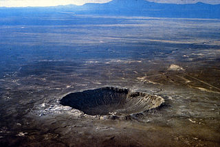
A crater is a landform consisting of a hole or depression on a planetary surface, usually caused either by an object hitting the surface, or by geological activity on the planet. A crater has classically been described as: "a bowl-shaped pit that is formed by a volcano, an explosion, or a meteorite impact". On Earth, craters are "generally the result of volcanic eruptions", while "meteorite impact craters are common on the Moon, but are rare on Earth".
Tocorpuri is a volcano in Chile, close to the border with Bolivia. Its peak height is most recently given as 5,808 metres (19,055 ft) and it features a 1.3 kilometres (0.81 mi) wide summit crater. The volcano consists mainly of lava flows and pyroclastic deposits and is subdivided into two separate edifices. Just west of Tocorpuri, the La Torta lava dome is a 200 metres (660 ft) high flat-topped structure. The volcanoes are formed by andesitic, dacitic and rhyolitic rocks.
 Crater following explosion
 Volcanic crater
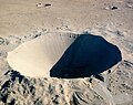
