Crawfish Creek (Wyoming)

Last updated
Crawfish Creek
River
CrawfishCreek.JPG
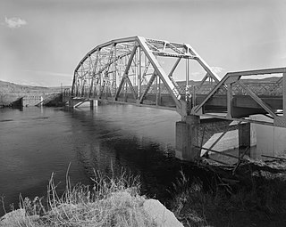
Bridge across Crawfish Creek, 1989
Country United States
State Wyoming
Source
 - location 44°10′47″N110°42′08″W / 44.17972°N 110.70222°W / 44.17972; -110.70222 (Crawfish Creek source) [1] , Yellowstone National Park , Wyoming
Mouth
 - location Lewis River 44°09′02″N110°40′05″W / 44.15056°N 110.66806°W / 44.15056; -110.66806 (Crawfish Creek mouth) Coordinates: 44°09′02″N110°40′05″W / 44.15056°N 110.66806°W / 44.15056; -110.66806 (Crawfish Creek mouth) [1] , Yellowstone National Park , Wyoming
 - elevation 6,913 ft (2,107 m)

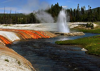
Crawfish Creek is a short stream in Yellowstone National Park [2] in the U.S. state of Wyoming [3] This watercourse is known for its unusually warm temperatures compared to other surface water bodies in Wyoming; these elevated temperatures enable crawfish to thrive in the water. Summer water temperatures are in the range of 22 to 24 degrees Celsius; pH levels are typically about 9.1, or somewhat alkaline. [4] The warm waters come from a southern portion of the Yellowstone volcanic zone which produces hot water from hot springs and fumaroles in the area. The stream feeds into the Lewis River just south of the Lewis River Canyon and just before the Lewis River converges with the Snake River.

Stream A body of surface water flowing down a channel

A stream is a body of water with surface water flowing within the bed and banks of a channel. The stream encompasses surface and groundwater fluxes that respond to geological, geomorphological, hydrological and biotic controls.

Yellowstone National Park first national park in the world, located in the US states Wyoming, Montana and Idaho

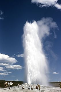
Yellowstone National Park is an American national park located in Wyoming, Montana, and Idaho. It was established by the U.S. Congress and signed into law by President Ulysses S. Grant on March 1, 1872. Yellowstone was the first national park in the U.S. and is also widely held to be the first national park in the world. The park is known for its wildlife and its many geothermal features, especially Old Faithful geyser, one of its most popular features. It has many types of ecosystems, but the subalpine forest is the most abundant. It is part of the South Central Rockies forests ecoregion.

U.S. state constituent political entity of the United States

In the United States, a state is a constituent political entity, of which there are currently 50. Bound together in a political union, each state holds governmental jurisdiction over a separate and defined geographic territory and shares its sovereignty with the federal government. Due to this shared sovereignty, Americans are citizens both of the federal republic and of the state in which they reside. State citizenship and residency are flexible, and no government approval is required to move between states, except for persons restricted by certain types of court orders. Four states use the term commonwealth rather than state in their full official names.

30 feet (9.1 m) Moose Falls is located 75 yards (69 m) upstream from the Crawfish Creek confluence with the Lewis River.

Moose Falls

Moose Falls is a plunge type waterfall on Crawfish Creek in Yellowstone National Park. The waterfall was named in 1885 by members of the Arnold Hague Geologic Survey for the plentiful moose found in the southern sections of the park. The falls are just 75 yards (69 m) west of south entrance road via an easy trail that begins 1.2 miles (1.9 km) north of the south entrance station.

The watershed of Crawfish Creek is densely forested with lodgepole pine, Douglas fir and other tree species.

Douglas fir species of tree

Pseudotsuga menziesii is an evergreen conifer species in the pine family, Pinaceae. It is native to western North America and is known as Douglas fir, Douglas-fir, Oregon pine, and Columbian pine. There are two varieties: coast Douglas-fir, and Rocky Mountain Douglas-fir.

In biology, a species ( ) is the basic unit of classification and a taxonomic rank of an organism, as well as a unit of biodiversity. A species is often defined as the largest group of organisms in which any two individuals of the appropriate sexes or mating types can produce fertile offspring, typically by sexual reproduction. Other ways of defining species include their karyotype, DNA sequence, morphology, behaviour or ecological niche. In addition, paleontologists use the concept of the chronospecies since fossil reproduction cannot be examined. While these definitions may seem adequate, when looked at more closely they represent problematic species concepts. For example, the boundaries between closely related species become unclear with hybridisation, in a species complex of hundreds of similar microspecies, and in a ring species. Also, among organisms that reproduce only asexually, the concept of a reproductive species breaks down, and each clone is potentially a microspecies.

Notes

  1. 1 2 U.S. Geological Survey Geographic Names Information System: Crawfish Creek
  2. U.S. Geological Survey, Quadrangle Map
  3. Trails Unlimited, "Yellowstone National Park", 2002, National Geographic Soc.
  4. C.M. Hogan, Lumina Tech, Water Quality Baslines in selected surface waters of Grand Teton and Yellowstone National Parks, 2007

Related Research Articles

Old Faithful geyser in Yellowstone National Park in Wyoming, United States

Old Faithful is a cone geyser located in Yellowstone National Park in Wyoming, United States. It was named in 1870 during the Washburn-Langford-Doane Expedition and was the first geyser in the park to receive a name. It is a highly predictable geothermal feature, and has erupted every 44 to 125 minutes since 2000. The geyser and the nearby Old Faithful Inn are part of the Old Faithful Historic District.

Geothermal areas in Lassen Volcanic National Park

The geothermal areas in Lassen Volcanic National Park include several groups of hot springs and fumaroles, as remnants of former volcanic activity, exist in Lassen Volcanic National Park. Most of these lie in or are closely adjacent to Mount Tehama's caldera. Bumpass Hell is the most spectacular of these, but others of importance are Sulphur Works, Little Hot Springs Valley, Boiling Springs Lake and Devil's Kitchen. In each thermal area, the highest temperature of water generally is close to the boiling temperature at the altitude of the particular spring or fumarole — 198 °F (92 °C) at Bumpass Hell and 191 °F (88 °C) on the northwest flanks of Lassen Peak. Temperatures as high as 230 °F (110 °C) have been recorded in the park.

Yellowstone Caldera volcanic caldera in Yellowstone National Park in the United States

The Yellowstone Caldera is a volcanic caldera and supervolcano in Yellowstone National Park in the Western United States, sometimes referred to as the Yellowstone Supervolcano. The caldera and most of the park are located in the northwest corner of Wyoming. The major features of the caldera measure about 34 by 45 miles.

Bighorn River river in the United States of America

The Bighorn River is a tributary of the Yellowstone, approximately 461 miles (742 km) long, in the states of Wyoming and Montana in the western United States. The river was named in 1805 by fur trader François Larocque for the bighorn sheep he saw along its banks as he explored the Yellowstone.

Yellowstone River tributary of the Missouri River in the western United States

The Yellowstone River is a tributary of the Missouri River, approximately 692 miles (1,114 km) long, in the western United States. Considered the principal tributary of the upper Missouri, the river and its tributaries drain a wide area stretching from the Rocky Mountains in the vicinity of the Yellowstone National Park across the mountains and high plains of southern Montana and northern Wyoming.

Madison River river in Montana and Wyoming, United States

The Madison River is a headwater tributary of the Missouri River, approximately 183 miles (295 km) long, in Wyoming and Montana. Its confluence with the Jefferson and Gallatin rivers near Three Forks, Montana forms the Missouri River.

Gallatin River river in the United States of America

The Gallatin River is a tributary of the Missouri River, approximately 120 mi, in the U.S. states of Wyoming and Montana. It is one of three rivers, along with the Jefferson and Madison, that converge near Three Forks, Montana, to form the Missouri.

Lamar River river in the United States of America

The Lamar River is a tributary of the Yellowstone River, approximately 40 miles (48 km) long, in northwestern Wyoming in the United States. The river is located entirely within Yellowstone National Park.

Slough Creek (Wyoming) river in the United States of America

Slough Creek is a tributary of the Lamar River, approximately 25 mi (40 km) long, in Montana and Wyoming in the United States.

Clarks Fork Yellowstone River river in the United States of America

The Clarks Fork of the Yellowstone River is a tributary of the Yellowstone River, 150 mi (241 km) long in the U.S. states of Montana and Wyoming.

Firehole River river in the United States of America

The Firehole River is located in northwestern Wyoming, and is one of the two major tributaries of the Madison River. It flows north approximately 21 miles (34 km) from its source in Madison Lake on the Continental Divide to join the Gibbon River at Madison Junction in Yellowstone National Park. It is part of the Missouri River system.

Two Ocean Pass

Two Ocean Pass is a mountain pass on North America's Continental Divide, in the Teton Wilderness, which is part of Wyoming's Bridger-Teton National Forest. The pass is notable for Parting of the Waters, where one stream, North Two Ocean Creek, splits into two distributaries, Pacific Creek and Atlantic Creek, at Parting of the Waters National Natural Landmark. These two creeks ultimately flow into their respective oceans. Atlantic Creek water eventually flows into the Yellowstone River and empties into the Gulf of Mexico via the Missouri River and Mississippi River. Pacific Creek water eventually flows into the Snake River and empties into the Pacific via the Columbia River.

Angling in Yellowstone National Park

Angling in Yellowstone National Park is a major reason many visitors come to the park each year and since it was created in 1872, the park has drawn anglers from around the world to fish its waters. In 2006, over 50,000 park fishing permits were issued to visitors. The park contains hundreds of miles of accessible, high-quality trout rivers containing wild trout populations—over 200 creeks, streams and rivers are fishable. There are 45 fishable lakes and several large lakes are easily accessible to visitors. Additionally, the park's remote sections provide anglers ample opportunity to visit rivers, streams, creeks and lakes that receive little angling pressure. With the exception of one specially designated drainage, all the park's waters are restricted to artificial lures and fly fishing. The Madison, Firehole and a section of the Gibbon rivers are restricted to fly fishing only.

Outline of Yellowstone National Park Wikimedia list article

The following articles relate to the history, geography, geology, flora, fauna, structures and recreation in Yellowstone National Park.

Lewis Lake (Wyoming) Lake in Teton County, Wyoming, USA

Lewis Lake is located in the U. S. state of Wyoming in the southern part of Yellowstone National Park, about 4 miles (6.4 km) southeast of Shoshone Lake, and approximately 10 miles (16 km) southwest of Yellowstone Lake. Lewis Lake and Shoshone Lake are both located a few miles northeast of the Pitchstone Plateau.

Specimen Ridge mountain in United States of America

Specimen Ridge, el. 8,379 feet (2,554 m) is an approximately 8.5-mile (13.7 km) ridge along the south rim of the Lamar Valley in Yellowstone National Park. The ridge separates the Lamar Valley from Mirror Plateau. The ridge is oriented northwest to southeast from the Tower Junction area to Amethyst Mountain. The ridge is known for its abundance of amethyst, opal and petrified wood. It was referred to as Specimen Mountain by local miners and was probably named by prospectors well before 1870. The south side of the ridge is traversed by the 18.8-mile (30.3 km) Specimen Ridge Trail between Tower Junction and Soda Butte Creek. The trail passes through the Petrified Forest and over the summit of Amethyst Mountain el. 9,614 feet (2,930 m).

Shoshone Lake Lake in Teton County, Wyoming, USA

Shoshone Lake is a U.S. backcountry lake with the area of 8,050 acres elevated at 7,795 feet (2,376 m) in the southwest section of Yellowstone National Park, Wyoming. It lies at the headwaters of the Lewis River a tributary of the Snake River. The U.S. Fish and Wildlife Service believes that Shoshone Lake is the largest backcountry lake in the lower 48 states that cannot be reached by a road.

Amethyst Mountain, el. 9,609 feet (2,929 m) is the highest peak and central part of a northwest – southeast trending ridge that lies between the Lamar River to the northeast and Deep Creek to the southwest within Park County, Wyoming. From northwest to southeast, this ridge consists of Specimen Ridge, Amethyst Mountain, and the Mirror Plateau in Yellowstone National Park. The nearest town is Silver Gate, Montana, which is 19.2 miles away.