Related Research Articles

Mid Devon is a local government district in Devon, England. Its council is based in Tiverton.
Black Torrington is a village and civil parish in mid Devon, England, situated between the towns of Holsworthy and Hatherleigh. It is located on and named after the River Torridge.
Tiverton and Honiton is a constituency in Devon, England. The current MP is Richard Foord of the Liberal Democrats, elected at a by-election on 23 June 2022.

Exminster is a village situated on the southern edge of the City of Exeter on the western side of the Exeter ship canal and River Exe in the county of Devon, England. It is around 6 km (3.7 mi) south of the centre of Exeter, and has a population of 3,084, increasing to 3,368 at the 2011 census.

Willand is a village and civil parish in Mid Devon, England. It is about 19 km (12 mi) north of Exeter and 2.4 km (1.5 mi) north of Cullompton. In 1991 the population was 3750 although recently this has grown considerably. The National Grid reference for the centre of the area is ST037110. Willand is a major part of Lower Culm electoral ward. The ward population at the 2011 Census was 5,808. The parish is surrounded, clockwise from the north, by the parishes of Halberton, Uffculme and Cullompton.

Brushford is a village and civil parish in the Mid Devon district of Devon in England. According to the 2001 census it had a population of 59. The village is situated on the River Taw, and is about 12 miles north-east of Okehampton.
Buckland Filleigh is a village, civil parish and former manor in the Torridge district of North Devon, England, situated about 8 miles south of the town of Great Torrington. According to the 2001 census, the parish had a population of 170. It is surrounded clockwise from the north by the parishes of Peters Marland, Petrockstowe, Highampton, Sheepwash and Shebbear.

Sampford Peverell is a village and civil parish in Mid-Devon, England. An old Saxon settlement, it was called Sanforda in the 1086 Doomsday Book. Its current name reflects its inclusion in the Honour of Peverel, the lands of William Peverel and his family. His great-grandson, Hugh Peverell, is buried in the village church of St John the Baptist. The Grand Western Canal cuts through the village.

Uffculme is a village and civil parish located in the Mid Devon district, of Devon, England. Situated in the Blackdown Hills on the B3440, close to the M5 motorway and the Bristol–Exeter railway line, near Cullompton, Uffculme is on the upper reaches of the River Culm. The population of the parish, according to a 2020 estimate, is 3,090. It is surrounded, clockwise from the north, by the parishes of Culmstock, Hemyock, Sheldon, Kentisbeare, Cullompton, Willand, Halberton and Burlescombe.

Oakford is a village and civil parish in the Mid Devon district of Devon, England. It is located three miles (5 km) south west of Bampton and eight miles (13 km) north north west of Tiverton. Oakford is near the river Exe.

Huntsham Castle, Devon, England is an Iron Age Hill fort enclosure near the village of Huntsham, it is located 260 m (850 ft) above sea level on the edge of the former Parish of Tiverton. The monument includes a slight univallate hillfort situated on a prominent hill overlooking the valleys of two separate tributaries to the River Lowman. The monument survives as a sub-circular enclosure, defining an area which slopes gently down to the south and measures approximately 150m in diameter. It is clearly demarcated on all sides by a rampart which varies in height from 1m up to 2.4m internally, being generally of greater height on the northern side of the enclosure. Externally this rampart is up to 2.9m high. Surrounding the rampart is an outer ditch which measures up to 5.4m wide and 0.4m deep and this is visible on all sides of the monument, although it is predominantly preserved as a buried feature. On the north eastern side, the outer edge of this ditch is defined by a field boundary bank and the infilled ditch has been used in the past as a track. There is an inturned entrance on the north eastern side which measures 7m wide, and the inturned banks are up to 2.2m wide and 0.4m high. The enclosure is crossed by a parish boundary bank which measures up to 2m wide and 1.5m high, and has been partially cut at the north eastern corner by a quarry, approximately 20m long, 15m wide and up to 2.8m deep, which lies to the north of the entrance. A further quarry lies to the south of the parish boundary bank, on the western side of the enclosure and measures 8.7 metres (29 ft) long, 5.3 metres (17 ft) wide and up to 1 metre (3.3 ft) deep. A third quarry lies to the north west and has partially cut into the ditch and rampart on this side; however much of this quarry lies just beyond the monument itself. A further entrance to the enclosure may lie on the western side, where the rampart is seen to kink slightly inwards. The stock proof fences around the rampart and ditch, the gates and gateposts which facilitate access, the Ordnance Survey triangulation point which is situated on the north eastern side of the enclosure just above the quarry, and the field boundary bank which defines the outer edge of the ditch in the north eastern corner are excluded from the scheduling, although the ground beneath all these features is included.

Castle Close is a circular earthwork located near Stoodleigh in Mid Devon, England at OS grid reference SS937181. It is described on maps as a settlement. Situated some 208 metres above sea level, overlooking the River Exe, it is most likely to be an Iron Age Hill fort or enclosure.
There are 22 disused railway stations in the 75 miles (121 km) between Bristol Temple Meads and Exeter St Davids, 12 of which have structures that can still be seen from passing trains. Most were closed in the 1960s but four of them, especially around Weston-super-Mare, were replaced by stations on new sites. 13 stations remain open on the line today, but there have been proposals to reopen stations at Cullompton and Wellington.

There are eleven disused railway stations between Exeter St Davids and Plymouth Millbay, Devon, England. At eight of these there are visible remains. Of the eleven stations, South Brent and Plympton are subject of campaigns for reopening while Ivybridge station was replaced by another station on a different site.

Witheridge is a village and civil parish in the North Devon district of Devon, England. In 2001 the population of the parish was 1162, reducing slightly to 1,158 at the 2011 Census. An electoral ward with the same name exists. The population at the above census was 2,313. Its name may be derived from the Old English for "Weather Ridge", which would fit with the village's somewhat exposed situation.

Woolfardisworthy is a village and civil parish in Mid Devon. It is situated about 9 km north of Crediton.

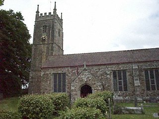
Uplowman is a village and civil parish in Devon, situated about 4 miles north-east of the town of Tiverton. The parish is surrounded, clockwise from the north, by the parishes of Hockworthy, Sampford Peverell, Halberton, Tiverton, and Huntsham. It is situated near the River Lowman, and further downstream, to the west, is Crazelowman.

Wembworthy is a small village, parish and former manor in Mid-Devon, England. It is situated in the valley of the River Taw, 8 miles north-east of the towns of Hatherleigh and 12 miles south of South Molton. St Michael's Church is the parish church, much rebuilt in the 1840s. The vestigial remnants of two mediaeval earthwork castles survive within the parish, one in Heywood Wood, of motte and bailey form, the other to its south of ringwork and bailey form.

West Ogwell is a village and former civil parish and manor in Devon, England, located 2 miles south-west of the town of Newton Abbot and 1 mile west of the village of East Ogwell. It is now in the civil parish of Ogwell, administered by Teignbridge District Council. The church and manor house "lie hidden away on their own".

Clannaborough is a parish in the county of Devon, England, situated about 5+1⁄2 miles north-west of the town of Crediton and 11 miles north-east of Okehampton. No village exists, only scattered farmhouses, including Clannaborough Barton and the bartons of Appledore and Walson, all three estates listed in the Domesday Book of 1066. Walson was the birthplace of Christopher Lethbridge (d.1670), Mayor of Exeter in 1660, who was lord of the manor of nearby Bow. The parish church is dedicated to St Petrock.
References
- ↑ "Craze Lowman, Mid Devon - area information, map, walks and more". OS GetOutside. Retrieved 12 October 2017.
Coordinates: 50°55′05″N3°26′46″W / 50.918°N 3.446°W
| | This Devon location article is a stub. You can help Wikipedia by expanding it. |