
The M56 motorway, also known as the North Cheshire motorway, serves the Cheshire and Greater Manchester areas of England. It runs east to west from junction 4 of the M60 at Gatley, south of Manchester, to Dunkirk, approximately four miles north of Chester. With a length of 33.3 miles (53.6 km), it connects North Wales and the Wirral peninsula with much of the rest of North West England, serves business and commuter traffic heading towards Manchester, particularly that from the wider Cheshire area, and provides the main road access to Manchester Airport from the national motorway network.
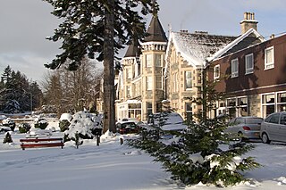
Grantown-on-Spey is a town in the Highland Council Area, historically within the county of Moray. It is located on a low plateau at Freuchie beside the river Spey at the northern edge of the Cairngorm mountains, about 20 miles (32 km) south-east of Inverness.

The Glenfinnan Viaduct is a railway viaduct on the West Highland Line in Glenfinnan, Inverness-shire, Scotland, built from 1897 to 1901. Located at the top of Loch Shiel in the West Scottish Highlands, the viaduct overlooks the Glenfinnan Monument and the waters of Loch Shiel.
The Callander and Oban Railway company was established with the intention of linking the sea port of Oban to the railway network. This involved a long line from Callander through wild and thinly populated terrain, and shortage of money meant that the line was opened in stages from 1866 to 1880.
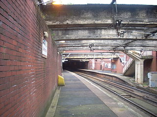
Dalmarnock railway station, serving the Dalmarnock area of Glasgow, Scotland, lies on the Argyle Line, two and a quarter miles (3.6 km) southeast of Glasgow Central. The northern ends of the side platforms are within a tunnel. Revamped for the 2014 Commonwealth Games, the station is a 15-minute walk from the Commonwealth Arena and Sir Chris Hoy Velodrome, and Celtic football club's Celtic Park stadium at Parkhead.

The Cornwall Railway company constructed a railway line between Plymouth and Truro in the United Kingdom, opening in 1859, and extended it to Falmouth in 1863. The topography of Cornwall is such that the route, which is generally east–west, cuts across numerous deep river valleys that generally run north–south. At the time of construction of the line, money was in short supply due to the collapse in confidence following the railway mania, and the company sought ways of reducing expenditure.

The Tay Bridge disaster occurred during a violent storm on Sunday 28 December 1879, when the first Tay Rail Bridge collapsed as a North British Railway (NBR) passenger train on the Edinburgh to Aberdeen Line from Burntisland bound for its final destination of Dundee passed over it, killing all aboard. The bridge—designed by Sir Thomas Bouch—used lattice girders supported by iron piers, with cast iron columns and wrought iron cross-bracing. The piers were narrower and their cross-bracing was less extensive and robust than on previous similar designs by Bouch.

The Medway Viaducts are three bridges or viaducts that cross the River Medway between Cuxton and Borstal in north Kent, England. The two road bridges carry the M2 motorway carriageways. The other viaduct carries the High Speed 1 railway line. All three bridges pass over the Medway Valley Line.

Almondell and Calderwood Country Park is a 220-acre (0.89 km2) Country Park in Mid Calder and East Calder in West Lothian, Scotland. It is a 4 star Visitor Attraction (Visitscotland). The Park is split into two main areas, Almondell Park which comprises the Almondell estate which originally belonged to the Erskine family of Broxburn and the Calderwood estate which once belonged to the Barons of Torphichen.

The Alloa Swing Bridge was a railway swing bridge across the River Forth that connected Throsk and Alloa as part of the Alloa Railway. The structure was in use from 1885 until 1968.
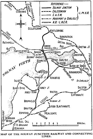
The Solway Junction Railway was built by an independent railway company to shorten the route from ironstone mines in Cumberland to ironworks in Lanarkshire and Ayrshire.

The Ingleton branch line was a rural railway line in the West Riding of Yorkshire, Lancashire and Westmorland in England. It was originally planned in 1846 to form part of a main line route from London to Scotland, but fell victim to rivalry between railway companies. Completion was delayed until 1861, and it was only ever a rural branch line, serving the towns of Ingleton, Kirkby Lonsdale and Sedbergh. It closed to passengers in 1954 and was dismantled in 1967.
The North British, Arbroath and Montrose Railway was a company established by Act of Parliament in 1871 to construct and operate a railway line from north of Arbroath via Montrose to Kinnaber Junction, 38 miles (61 km) south of Aberdeen. The company was originally a subsidiary of the North British Railway but was absorbed into its parent in 1880.
Events from the year 1848 in Scotland.

The Clydebridge Steelworks, also known as Clydebridge Works, is a steel works in South Lanarkshire, Scotland.

The Biggest Little Railway in the World (BLR) was a temporary 71 mile (114 km) 1.25 inches (32 mm) O-gauge model railway from Fort William to the City of Inverness, the two largest settlements in the Scottish Highlands. It has been described as a crackpot project to run a model train the length of the Great Glen Way by an army of madcap enthusiasts, geeks, and engineers in the best spirit of eccentric Britishness.

Kingston is an area of Glasgow, Scotland, from which the Kingston Bridge takes its name. Together with Ibrox, it forms one of the 56 neighbourhoods of Glasgow defined by Glasgow City Council for operational purposes. The area was assigned to Ward 54 until 2007 when it was reclassified as part of the Govan ward.
The Findhorn Viaduct is a railway bridge near Forres in Moray, Scotland. Built for the Inverness & Aberdeen Junction Railway between 1856 and 1858 by Joseph Mitchell, with ironwork by William Fairbairn & Sons of Manchester, the viaduct carries the railway line over the River Findhorn approximately 1.7 km west of the town of Forres.

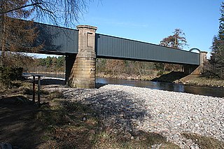
The Findhorn Viaduct is a railway bridge approximately 500 metres east of the village of Tomatin in the Scottish Highlands, which carries the Perth to Inverness railway line over the valley of the River Findhorn.

The North Water Viaduct is a disused railway viaduct located north of Montrose, Scotland. It was built by the Montrose and Bervie Railway and crosses the River North Esk. It has eleven spans. It is located adjacent to the older Lower North Water Bridge which carries the A92 road.

