Related Research Articles

Isle de France was a French colony in the Indian Ocean from 1715 to 1810, comprising the island now known as Mauritius and its dependent territories. It was governed by the French East India Company and formed part of the French colonial empire. Under the French, the island witnessed major changes. The increasing importance of agriculture led to the "import" of slaves and the undertaking of vast infrastructural works that transformed the capital Port Louis into a major port, warehousing, and commercial centre.
The Outer Islands of Mauritius is the first-level administrative divisions of the country and consists of the islands of Mauritius and several outlying islands. The Outer Islands of Mauritius are managed under the aegis of the Prime Minister of Mauritius through Prime Minister's Office by the Outer Islands Development Corporation which is the authority empowered under the law to manage the Outer Islands of Mauritius. The Prime Minister is also Minister for Rodrigues, Outer Islands and Territorial Integrity. The Constitution of Mauritius states that the Republic of Mauritius includes the islands of Agaléga, Mauritius, Rodrigues, Saint Brandon, Tromelin Island, and the Chagos Archipelago. The Government of Mauritius claims sovereignty over the Chagos Archipelago, which the United Kingdom split from its territories to create the British Indian Ocean Territory before its independence in 1968. Additionally, France shares a sovereignty claim over Tromelin Island, an uninhabited island between Madagascar and Mauritius's main island.

Flacq is a district of Mauritius, situated in the east of the island. It is the largest district, with an area of 297.9 km². The population estimate is 138,221.
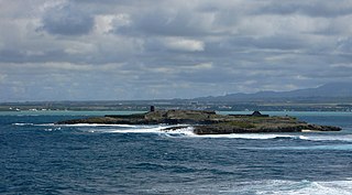
Île de la Passe is a rocky islet in the bay off Grand Port on the island of Mauritius. Between 20 and 25 August 1810, during the British campaign to capture the island from the French, it was the scene of the Battle of Grand Port. This was a long and very hard-fought action between roughly equal forces of French and British frigates and, on balance, a defeat for the British, who lost four frigates, though one of these was subsequently recaptured. The French squadron did not survive the British invasion of Mauritius.
The National Assembly is Mauritius's unicameral legislature, which was called the Legislative Assembly from 1968 until 1992, when the country became a republic. Prior to 1968 and under British rule it was known as the Legislative Council. The Constitution of Mauritius provides for the parliament of Mauritius to consist of the President and the National Assembly. The parliament of Mauritius is modelled after the Westminster system of parliamentary democracy, where members of parliament are voted in at regular general elections, on the basis of a first past the post system. The working language of the National Assembly is English.
Athos Range is the northernmost range in the Prince Charles Mountains of Mac. Robertson Land, Antarctica. The range consists of many individual mountains and nunataks that trend east–west for 40 miles (64 km) along the north side of Scylla Glacier.
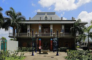
The Blue Penny Museum a museum dedicated to history and art of Mauritius, is situated at Caudan Waterfront in Port Louis, the capital of Mauritius. It opened in November 2001.

Trou-aux-Biches is a small town with a public beach on the northern coast of Mauritius, in the district of Pamplemousses. According to the World Travel group, the beach is one of the most beautiful on the island. They awarded it the World's Leading Beach Destination at the World Travel Award for 2011. Many tourist resorts and boutique hotels are situated near the beach, such as the Trou aux Biches Resort & Spa. From Port Louis, the M2 highway heads towards it, with Trou-aux-Biches about a mile west from the end of M2. The airport and the town are connected by a public bus.

Black River Gorges National Park is a national park in the hilly south-western part of Mauritius. It was proclaimed on June 15, 1994 and is managed by the National Parks and Conservation Service. It covers an area of 67.54 km2 including humid upland forest, drier lowland forest and marshy heathland. Facilities for visitors include two information centres, picnic areas and 60 kilometres of trails. There are four field stations in the park which are used for National Parks and Conservation Service and Mauritian Wildlife Foundation research and conservation projects. It is the largest national park in Mauritius.

The Savoia-Marchetti S.72 was an Italian three-engine transport monoplane designed and built by Savoia-Marchetti as an enlarged and strengthened version of the earlier S.71. The S.72 was a three-engine, high-wing cantilever monoplane with a fixed tailwheel landing gear. Designed as a heavy bomber, the prototype was first flown in 1934 powered by three 410 kW (550 hp) Alfa Romeo licence-built Bristol Pegasus radial engines.
Saint Pierre is a village in the district of Moka in Mauritius. It is considered to be found in the heart of Mauritius.The climatic conditions is cold and ideal especially during summer with cold breeze.
Loreto College Rose Hill is a private secondary girls' school in Rose Hill, Mauritius. One of seven Loreto College campuses in Mauritius, it opened in 1951. Cathy de Cazanove is the current rector and the asst. rector is Roselyn Thomas.
Midlands is a small village in the Plaines Wilhems district of Mauritius. The village is situated approximately halfway between Nouvelle France and Curepipe on the M2 motorway. Midlands is on the highlands of the island at approximately 386 metres.

Mauritius was a Crown colony off the southeast coast of Africa. Formerly part of the French colonial empire, British rule in Mauritius was established de facto with the invasion of Isle de France in November 1810, and de jure by the subsequent Treaty of Paris. British rule ended on 12 March 1968, when Mauritius became an independent country.

Between independence in 1968 and becoming a republic in 1992, Mauritius was an independent sovereign state that shared its head of state with the United Kingdom and other states headed by Elizabeth II.
The Open University of Mauritius (OU) is a public university in Mauritius. It offer programmes leading to undergraduate, and postgraduate degrees through open distance learning. OU's headquarters are located in Réduit, Moka.
The National Archives of Mauritius are located in Coromandel, Mauritius. The archives were officially established in 1815, one of the earliest such institutions established in the Southern Hemisphere.
The AfrAsia Bank Mauritius Open is a men's professional golf tournament co-sanctioned by the European Tour and Sunshine Tour, and formerly by the Asian Tour. It began in 2015 and was initially played at Heritage Golf Club in Bel-Ombre, Mauritius. In 2016 and 2018, the tournament was held at Anahita Golf Club, returning to Heritage Golf Club in 2017 and in 2019. The 2015 and 2016 events were played in May but in 2017 it was moved to December and was part of the 2018 European Tour schedule.
References
20°11′S57°33′E / 20.183°S 57.550°E
| | This Mauritius location article is a stub. You can help Wikipedia by expanding it. |