The Presidio of San Francisco is a park and former U.S. Army post on the northern tip of the San Francisco Peninsula in San Francisco, California, and is part of the Golden Gate National Recreation Area.

Gateway National Recreation Area is a 26,607-acre (10,767 ha) U.S. National Recreation Area in New York City and Monmouth County, New Jersey. It provides recreational opportunities that are not commonly found in a dense urban environment, including ocean swimming, bird watching, boating, hiking and camping. More than 8.7 million people visited Gateway National Recreation Area in 2022, making it the fourth-most visited unit of the National Park Service.

The National Estuarine Research Reserve System is a network of 30 protected areas established by partnerships between the National Oceanic and Atmospheric Administration (NOAA) and coastal states. The reserves represent different biogeographic regions of the United States. The National Estuarine Research Reserve System protects more than 1.3 million acres of coastal and estuarine habitats for long-term research, water-quality monitoring, education, and coastal stewardship.

Indiana Dunes National Park is a national park of the United States located in northwestern Indiana managed by the National Park Service. It was authorized by Congress in 1966 as the Indiana Dunes National Lakeshore and was redesignated as the nation's 61st national park on February 15, 2019. The park runs for about 20 miles (32 km) along the southern shore of Lake Michigan and covers 15,349 acres (6,212 ha). Along the lakefront, the eastern area is roughly the lake shore south to U.S. 12 or U.S. 20 between Michigan City, Indiana, on the east and the Cleveland-Cliffs steel plant on the west. This area's conservation scheme is enhanced by the older Indiana Dunes State Park. To the west of the steel plant lies West Beach and a small extension south of the steel mill continues west along Salt Creek to Indiana 249. The western area is roughly the shoreline south to U.S. 12 between the Burns Ditch west to Broadway in downtown Gary, Indiana. In addition, there are several outlying areas, including Pinhook Bog, in LaPorte County to the east; the Heron Rookery in Porter County, the center of the park; and the Hoosier Prairie State Nature Preserve and the Hobart Prairie Grove, both in Lake County, the western end of the park.

The Oregon Dunes National Recreation Area is located on the Oregon Coast, stretching approximately 40 miles (64 km) north of the Coos River in North Bend to the Siuslaw River in Florence, and adjoining Honeyman State Park on the west. It is part of Siuslaw National Forest and is administered by the United States Forest Service.

Crissy Field is a public recreation area on the northern shore of the San Francisco Peninsula in California, United States, located just east of the Golden Gate Bridge. It includes restored tidal marsh and beaches.

Don Edwards San Francisco Bay National Wildlife Refuge (DESFBNWR) is a United States National Wildlife Refuge located in the southern part of San Francisco Bay, California. Its headquarters and visitor center are in the Baylands district of Fremont, next to Coyote Hills Regional Park, in Alameda County. The visitor center is on Marshlands Rd, off Thornton Ave.

The California State Coastal Conservancy is a non-regulatory state agency in California established in 1976 to enhance coastal resources and public access to the coast. The CSCC is a department of the California Natural Resources Agency. The agency's work is conducted along the entirety of the California coast, including the interior San Francisco Bay and is responsible for the planning and coordination of federal land sales to acquire into state land as well as award grant funding for improvement projects. The Board of Directors for the agency is made up of seven members who are appointed by the Governor of California and approved by the California Legislature, members of the California State Assembly and California State Senate engage and provide oversight within their legislative capacity.

The Golden Gate Biosphere Network is a voluntary coalition of federal, state and local government agencies, nonprofit organizations, universities, and private partners within the Golden Gate Biosphere region. The Network aims to protect the region's biodiversity and conserve its natural resources. The Network has been part of the UNESCO Man and Biosphere Programme since 1988.GGBN is also part of the US Biosphere Network as well as EuroMAB. It is recognized by UNESCO for its "significance for biological diversity conversation" and organizational efforts involving municipal authorities and private interests.

The Golden Gate National Recreation Area (GGNRA) is a U.S. National Recreation Area protecting 82,116 acres (33,231 ha) of ecologically and historically significant landscapes surrounding the San Francisco Bay Area. Much of the park is land formerly used by the United States Army. GGNRA is managed by the National Park Service and is the second-most visited unit of the National Park system in the United States, with more than 15.6 million visitors in 2022. It is also one of the largest urban parks in the world, with a size two-and-a-half times that of the consolidated city and county of San Francisco.
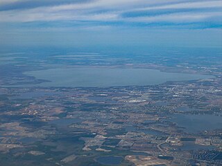
Lake Apopka is the fourth largest lake in the U.S. state of Florida. It is located 15 miles (24 km) northwest of Orlando, mostly within the bounds of Orange County, although the western part is in Lake County. Fed by a natural spring, rainfall and stormwater runoff, water from Lake Apopka flows through the Apopka-Beauclair Canal and into Lakes Beauclair and Dora. From Lake Dora, water flows into Lake Eustis, then into Lake Griffin and then northward into the Ocklawaha River, which flows into the St. Johns River. Multiple parks or nature trails are present around the lake including Magnolia Park, Lake Apopka Wildlife Drive, Ferndale Preserve, Oakland Nature Preserve, Dr. Bradford Memorial Park, and Newton Park, named for A. B. Newton.

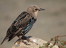
The U.S. Fish and Wildlife Service (USFWS) has a number of programs aimed at Mission blue butterfly habitat conservation, which include lands traditionally inhabited by the Mission blue butterfly, an endangered species. A recovery plan, drawn up by the U.S. Fish and Wildlife Service in 1984, outlined the need to protect Mission blue habitat and to repair habitat damaged by urbanization, off highway vehicle traffic, and invasion by exotic, non-native plants. An example of the type of work being done by governmental and citizen agencies can be found at the Marin Headlands in the Golden Gate National Recreation Area. In addition, regular wildfires have opened new habitat conservation opportunities as well as damaging existing ones.
The Golden Gate National Parks Conservancy is a nonprofit cooperating association that supports park stewardship and conservation in the Golden Gate National Recreation Area—the most visited national park in the U.S.
The Dotson Family Marsh, formerly Breuner Marsh, is a 238-acre regional park on San Pablo Bay in the East San Francisco Bay Area city of Richmond, California, In 2009 the East Bay Regional Parks District acquired the Breuner Marsh site, adding it to Point Pinole Regional Shoreline. A habitat restoration plan for 60 acres of wetlands and 90 acres of California coastal prairie was subsequently approved.
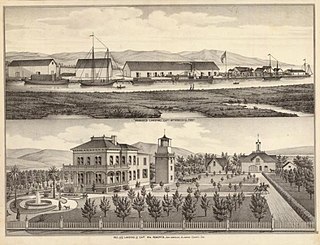
Roberts Landing was a settlement in Alameda County, California, now incorporated into the town of San Leandro. It is located at the mouth of San Lorenzo Creek on San Francisco Bay just west of the community of San Lorenzo. In the 19th century, it had warehouses and a wharf, and was used by farmers to ship their produce to the city of San Francisco. From 1906 to 1964, it was the site of an explosives manufacturing plant operated by the Trojan Powder Company. Following the plant's closure, the site was decontaminated. After protracted discussions, part was made into a housing development while a larger part was made an open space that is now also called the San Leandro Shoreline Marshlands.
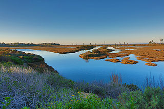
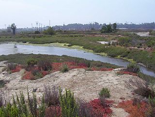
San Elijo Lagoon Ecological Reserve is one of the largest remaining coastal wetlands in San Diego County, California, United States.

Hoosier Prairie is a unit of Indiana Dunes National Park in Lake County, Indiana. It began in the 1970s as wasteland that conservation organization found of a unique interest. From a core of 304 acres (123 ha), it has grown to 1,547 acres (626 ha) of important prairie habitat. The area was designated a National Natural Landmark in 1974 and a State Nature Preserve in 1977 The sandy soil creates a variety of habitats, from oak barrens, wet prairie, including sedge meadows and prairie marshes. More than 350 native species of vascular plants have been identified. A minimum of 43 species are uncommon in the State of Indiana.
Los Cerritos Wetlands is located in both Los Angeles County and Orange County in the cities of Long Beach, California, and Seal Beach, California. The San Gabriel River, historically and currently flows through the Los Cerritos Wetlands Complex.

The Blanca Wetlands Area of Critical Environmental Concern, or Blanca Wildlife Habitat Area, is an area of the San Luis Valley in Colorado, United States, that serves as a refuge for birds, fish and other wildlife. It is about 11 miles (18 km) northeast of Alamosa on County Road 25. The wetlands had been completely destroyed by pumping and diversion of water for irrigation. Starting in 1965 the Bureau of Land Management began to restore them, and they have become an increasingly important ecological habitat for shorebirds, waterbirds and other wildlife and native plants.

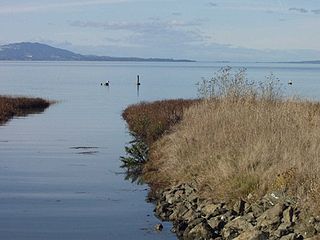
The San Francisco Bay Salt Ponds are a roughly 16,500-acre (6,700 ha) part of the San Francisco Bay that have been used as salt evaporation ponds since the California Gold Rush era. Most of the ponds were once wetlands in the cities of Redwood City, Newark, and Hayward, and other parts of the bay.