Geomorphology is the scientific study of the origin and evolution of topographic and bathymetric features generated by physical, chemical or biological processes operating at or near Earth's surface. Geomorphologists seek to understand why landscapes look the way they do, to understand landform and terrain history and dynamics and to predict changes through a combination of field observations, physical experiments and numerical modeling. Geomorphologists work within disciplines such as physical geography, geology, geodesy, engineering geology, archaeology, climatology, and geotechnical engineering. This broad base of interests contributes to many research styles and interests within the field.
The Lamont–Doherty Earth Observatory (LDEO) is the scientific research center of the Columbia Climate School, and a unit of The Earth Institute at Columbia University. It focuses on climate and earth sciences and is located on a 189-acre campus in Palisades, New York, 18 miles (29 km) north of Manhattan on the Hudson River.

The European Geosciences Union (EGU) is a non-profit international union in the fields of Earth, planetary, and space sciences whose vision is to "realise a sustainable and just future for humanity and for the planet." The organisation has headquarters in Munich (Germany). Membership is open to individuals who are professionally engaged in or associated with these fields and related studies, including students and retired seniors.

The following outline is provided as an overview of and topical guide to Earth science:

The US National Center for Atmospheric Research is a US federally funded research and development center (FFRDC) managed by the nonprofit University Corporation for Atmospheric Research (UCAR) and funded by the National Science Foundation (NSF). NCAR has multiple facilities, including the I. M. Pei-designed Mesa Laboratory headquarters in Boulder, Colorado. Studies include meteorology, climate science, atmospheric chemistry, solar-terrestrial interactions, environmental and societal impacts.

The Journal of Geophysical Research is a peer-reviewed scientific journal. It is the flagship journal of the American Geophysical Union. It contains original research on the physical, chemical, and biological processes that contribute to the understanding of the Earth, Sun, and Solar System. It has seven sections: A, B, C (Oceans), D (Atmospheres), E (Planets), F, and G (Biogeosciences). All current and back issues are available online for subscribers.

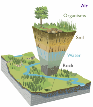
Earth's critical zone is the “heterogeneous, near surface environment in which complex interactions involving rock, soil, water, air, and living organisms regulate the natural habitat and determine the availability of life-sustaining resources”. The Critical Zone, surface and near-surface environment, sustains nearly all terrestrial life.

The Ocean Observatories Initiative (OOI) is a National Science Foundation (NSF) Major Research Facility composed of a network of science-driven ocean observing platforms and sensors in the Atlantic and Pacific Oceans. This networked infrastructure measures physical, chemical, geological, and biological variables from the seafloor to the sea surface and overlying atmosphere, providing an integrated data collection system on coastal, regional and global scales. OOI's goal is to deliver data and data products for a 25-year-plus time period, enabling a better understanding of ocean environments and critical ocean issues.
UNAVCO was a non-profit university-governed consortium that facilitated geology research and education using geodesy.
The Deep Carbon Observatory (DCO) is a global research program designed to transform understanding of carbon's role in Earth. DCO is a community of scientists, including biologists, physicists, geoscientists and chemists, whose work crosses several traditional disciplinary lines to develop the new, integrative field of deep carbon science. To complement this research, the DCO's infrastructure includes public engagement and education, online and offline community support, innovative data management, and novel instrumentation development.
The Deep Earth Carbon Degassing (DECADE) project is an initiative to unite scientists around the world to make tangible advances towards quantifying the amount of carbon outgassed from the Earth's deep interior into the surface environment through naturally occurring processes. DECADE is an initiative within the Deep Carbon Observatory (DCO).
Jane Kathryn Willenbring is an American geomorphologist and professor at Stanford University. She is best known for using cosmogenic nuclides to investigate landscape changes and dynamics. She has won multiple awards including the Antarctica Service Medal and the National Science Foundation CAREER Award.
Holly Michael is an American hydrogeologist and Associate Professor of geology at the University of Delaware's College of Earth, Ocean, and Environment.

Kamini Singha is a Professor in the department of Geology and Geological Engineering at the Colorado School of Mines, where she works on questions related to hydrogeology.
The deep biosphere is the part of the biosphere that resides below the first few meters of the surface. It extends down at least 5 kilometers below the continental surface and 10.5 kilometers below the sea surface, at temperatures that may reach beyond 120 °C (248 °F) which is comparable to the maximum temperature where a metabolically active organism has been found. It includes all three domains of life and the genetic diversity rivals that on the surface.

Donald L. Sparks is an American soil scientist, currently Unidel S. Hallock duPont Chair of Soil and Environmental Chemistry, Francis Alison Professor, and Director, Delaware Environmental Institute, University of Delaware.

Peter H. Barry is an American geochemist who is an associate scientist in the marine chemistry and geochemistry department at the Woods Hole Oceanographic Institution. He uses noble gases and stable isotopes to understand the volatile history and chemical evolution of Earth, including the dynamic processes of subduction, mantle convection and surface volcanism, which control the redistribution of chemical constituents between the crust and mantle reservoirs. Barry’s main research focus has been on high-temperature geochemistry, crust-mantle interactions and the behavior of volatile fluids in the lithosphere. He also studies crustal systems, the origin of high helium deposits, including hydrocarbon formation and transport mechanisms.
Suzanne Prestrud Anderson is an American geophysicist who is a professor at the University of Colorado Boulder. Her research considers chemical weathering and erosion, and how it shapes the architecture of critical zones. She is a Fellow of the Geological Society of America and the American Geophysical Union.

Laura J. Crossey is an American hydrologist and geochemist and Distinguished Professor of Earth and Planetary Sciences at the University of New Mexico (UNM). Crossey is part of UNM's Sustainable Water Resources Grand Challenge team, which studies water and climate in New Mexico and other arid regions. She has studied springs and groundwater in areas including the Western Desert of Egypt, Australia's Great Artesian Basin, Tibet, the Middle Rio Grande Basin and the Grand Canyon.
Dorothy Jane Merritts is an American geologist. She is the Harry W. & Mary B. Huffnagle Professor of Geosciences at Franklin & Marshall College. In 2022, Merritts was elected a Member of the National Academy of Sciences.


