Related Research Articles
Cowley County is one of the 141 cadastral divisions of New South Wales. It contains the locality of Cavan. It was originally bordered on the north, east and part of the south by the Murrumbidgee River, and on the west by the Goodradigbee River. A large part of the county was transferred to the Commonwealth to make the Australian Capital Territory in 1909, with the remaining part the area to the north-west of the ACT as far north as the Burrinjuck Dam, and thin strips of land along the western, southern and south-eastern borders of the ACT.
Napier is a locality in the Riverina district of New South Wales, Australia and also a civil parish of Buccleuch County, New South Wales.
Illalong is a rural locality just off the Burley Griffin Way in south New South Wales.
Peppercorn, New South Wales is a civil parish of Buccleuch County in Snowy Valleys Council, New South Wales.
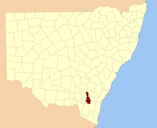
Clive, New South Wales is a civil parish of Buccleuch County in New South Wales, Australia.
Baloo, New South wales is a rural locality in the Snowy Mountains of New South wales and a civil Parish of the Buccleuch County.

Blowering, New South wales is a rural locality in the Snowy Mountains of New South wales and a civil Parish of Buccleuch County.
Bogong, New South Wales is a wilderness area in the Snowy Mountains of Australia.
Goobarragandra, New South Wales is a rural locality in the Snowy Mountains west of Canberra, Australia.
Wyangle, New South Wales is a bounded rural locality west of Canberra, Australia and about 16 km. north-east of Tumut.
Boraig, New South Wales is a rural locality in the Snowy Mountains, west of Canberra, Australia, and is also a civil Parish of Buccleuch County.

Birrema, New South Wales is a civil parish of Harden County, New South Wales.
Childowla, New South Wales is a civil parish of Buccleuch County, New South Wales.
Currawong, New South Wales, is rural locality of Hilltops Council and is a civil parish of Harden County, New South Wales.
Coppabella, New South Wales is a rural locality of Hilltops Council and a civil parish of Harden County, New South Wales.
Cowcumbala, New South Wales is a rural locality and civil parish of Harden County, New South Wales.
Cumbamurra, New South Wales is a civil parish of Harden County, New South Wales.
Murrimboola, New South Wales is a rural locality and civil parish of Harden County, New South Wales. The parish is at Harden, New South Wales, on Currawong Creek.
Bramina is a rural locality of the Snowy Mountains and a civil parish of Buccleuch County, New South Wales.
The Parish of Yarara is a civil parish of Cowley County, New South Wales. The parish is between the Murrumbidgee River and the Australian Capital Territory border and is heavily forested. It lies to the west of Michelago, but is cut off from it by the Murrumbidgee and is only accessible by road from Tharwa or Williamsdale. It forms part of the current locality of Clear Range, which had a population of 36 as of the 2016 census.
References
- ↑ Robert McLean, The New atlas of Australia : the complete work containing over one hundred maps and full descriptive geography of New South Wales, Victoria, Queensland, South Australia and Western Australia, together with numerous illustrations and copious indices (Sydney :J. Sands, [1886) Map 11.
- ↑ "Cromwell Parish". Geographical Names Register (GNR) of NSW. Geographical Names Board of New South Wales . Retrieved 18 April 2018.
- ↑ County of Cowley and Co. Buccleuch New South Wales, 1871 map, County of Cowley and Co. Buccleuch New South Wales, 1871 map.
- ↑ "Brindabella". OpenStreetMap. Retrieved 18 April 2018.
35°19′57″S148°41′02″E / 35.33250°S 148.68389°E
| | This New South Wales geography article is a stub. You can help Wikipedia by expanding it. |