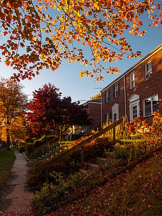
Parkville is an unincorporated community and census-designated place in Baltimore County, Maryland, United States. As of the 2010 census, the population was 30,734.

Towson is an unincorporated community and a census-designated place in Baltimore County, Maryland, United States. The population was 59,533 in the 2020 census. It is the county seat of Baltimore County and the second-most populous unincorporated county seat in the United States.

Interstate 695 (I-695) is a 51.46-mile-long (82.82 km) auxiliary Interstate Highway that constitutes a beltway extending around Baltimore, Maryland, United States. I-695 is officially designated the McKeldin Beltway but is colloquially referred to as either the Baltimore Beltway or 695. The route is an auxiliary route of I-95, intersecting that route southwest of Baltimore near Arbutus and northeast of the city near White Marsh. It also intersects other major roads radiating from the Baltimore area, including I-97 near Glen Burnie, the Baltimore–Washington Parkway near Linthicum, I-70 near Woodlawn, I-795 near Pikesville, and I-83 in the Timonium area. Originally, a 19.37-mile (31.17 km) portion of the Baltimore Beltway between I-95 northeast of Baltimore and I-97 south of Baltimore was officially Maryland Route 695 (MD 695) and was not part of the Interstate Highway System but is signed as I-695. The Francis Scott Key Bridge that crossed over the Patapsco River was included in this section of the route before the bridge's collapse on March 26, 2024. The bridge and its approaches were maintained by the Maryland Transportation Authority (MDTA), while the remainder of the Baltimore Beltway is maintained by the Maryland State Highway Administration (MDSHA). The American Association of State Highway and Transportation Officials approved the redesignation of MD 695 as I-695 on April 29, 2024.
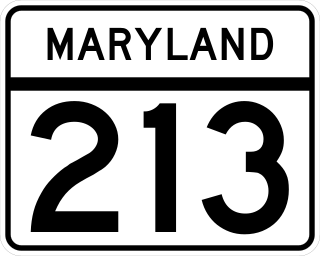
Maryland Route 213 (MD 213) is a 68.25-mile (109.84 km) state highway located on the Eastern Shore of Maryland in the United States. The route runs from MD 662 in Wye Mills, Queen Anne's County, north to the Pennsylvania border in Cecil County, where the road continues into that state as Pennsylvania Route 841 (PA 841). The route, which is a two-lane undivided highway most of its length, passes through mainly rural areas as well as the towns of Centreville, Chestertown, Galena, Cecilton, Chesapeake City, and Elkton. MD 213 intersects many routes including U.S. Route 50 (US 50) near Wye Mills, US 301 near Centreville, and US 40 in Elkton. It crosses over the Chesapeake & Delaware Canal in Chesapeake City on the Chesapeake City Bridge. MD 213 is designated by the state as the Chesapeake Country Scenic Byway between the southern terminus and Chesapeake City with the portion north of MD 18 in Centreville a National Scenic Byway. In addition, the route is also considered part of the Atlantic to Appalachians Scenic Byway between Chesapeake City and MD 273 in Fair Hill.

Harry Ward Gilmor served as the Baltimore City Police Commissioner, head of the Baltimore City Police Department in the 1870s, and a Confederate cavalry officer during the American Civil War. Gilmor's daring raids, including Gilmor's Raid through northern and central Maryland in July 1864 during the third major Confederate invasion of the North gained his partisans fame as "Gilmor's Raiders".

Maryland Route 41 is a state highway in the U.S. state of Maryland. Known for most of its length as Perring Parkway, the state highway runs 6.75 miles (10.86 km) from MD 147 in Baltimore north to Waltham Woods Road in Carney. MD 41 is a four- to six-lane divided highway that connects portions of Northeast Baltimore, including Morgan State University, with Parkville and Interstate 695 (I-695). The state highway is maintained by the Maryland State Highway Administration in Baltimore County and the Baltimore City Department of Transportation in the city, where it is unsigned. MD 41 was built in the early to mid-1960s, largely to relieve congestion on portions of neighboring Old Harford and Harford Roads during the period of rapid post-World War II growth in the area.

Maryland Route 147 is a state highway in the U.S. state of Maryland. Known as Harford Road, the state highway runs 18.82 miles (30.29 km) from U.S. Route 1 and US 40 Truck in Baltimore north to US 1 and US 1 Business in Benson. MD 147 is an alternate route to US 1 between Baltimore and Bel Air, the county seat of Harford County. The state highway is the main street of several neighborhoods in Northeast Baltimore and the Baltimore County suburbs of Parkville and Carney. MD 147 is maintained by the Maryland State Highway Administration in Baltimore and Harford counties and by the Baltimore City Department of Transportation within the city. Harford Road was a pair of turnpikes before the Baltimore–Carney portion of the highway was designated one of the original state roads. The Baltimore County section of MD 147 was constructed in the early 1910s and widened multiple times in the late 1920s and 1930s. The section of the state highway in Harford County was built in the late 1920s.

Charles Street, known for most of its route as Maryland Route 139, runs through Baltimore and the Towson area of Baltimore County. On the north end, it terminates at an intersection with Bellona Avenue near Interstate 695 (I-695). At the south end, it terminates in Federal Hill in Baltimore. Charles Street is one of the major routes through Baltimore, and is a major public transportation corridor. For the one-way portions of Charles Street, the street is functionally complemented by the parallel St. Paul Street, including St. Paul Place and Preston Gardens, Maryland Avenue, Cathedral Street, and Liberty Street.

Maryland Route 146 is a state highway in the U.S. state of Maryland. The state highway runs 16.81 miles (27.05 km) from MD 45 in Towson north to MD 23 near Jarrettsville. MD 146 connects Towson with Loch Raven Reservoir, an impoundment of Gunpowder Falls. The state highway also serves the northern Baltimore County community of Jacksonville and Jarrettsville in western Harford County. MD 146 was constructed as two different state highways on either side of Loch Raven Reservoir. The section of the state highway in Towson was built in the 1910s and the portion through Jacksonville to Jarrettsville was constructed in the late 1920s and early 1930s. The gap in MD 146 through Loch Raven Reservoir was filled in two steps of maintenance swaps in the early 1960s and late 1970s.

U.S. Route 1 (US 1) is the easternmost and longest of the major north–south routes of the older 1920s era United States Numbered Highway System, running from Key West, Florida, to Fort Kent, Maine. In the U.S. state of Maryland, it runs 81 miles (130 km) from the Washington, D.C. line to the Pennsylvania state line near the town of Rising Sun.
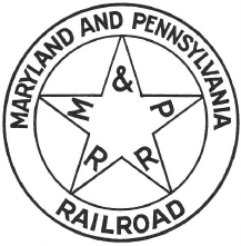
The Maryland and Pennsylvania Railroad, colloquially known as the "Ma and Pa", was an American short-line railroad between York and Hanover, Pennsylvania, formerly operating passenger and freight trains on its original line between York and Baltimore, Maryland, from 1901 until the 1950s. The Ma and Pa was popular with railfans in the 1930s and 1940s for its antique equipment and curving, picturesque right-of-way through the hills of rural Maryland and Pennsylvania. Reflecting its origin as the unintended product of the merger of two 19th-century narrow-gauge railways, the meandering main line took 77.2 miles (124 km) to connect Baltimore and York, although the two cities are only 45 miles (72 km) apart.

U.S. Route 40 in the U.S. state of Maryland runs from Garrett County in Western Maryland to Cecil County in the state's northeastern corner. With a total length of 221 miles (356 km), it is the longest numbered highway in Maryland. Almost half of the road overlaps or parallels with Interstate 68 (I-68) or I-70, while the old alignment is generally known as US 40 Alternate, US 40 Scenic, or Maryland Route 144. West of Baltimore, in the Piedmont and Appalachian Mountains / Blue Ridge region of the Western Maryland panhandle of the small state, the portions where it does not overlap an Interstate highway are mostly two-lane roads. The portion northeast of Baltimore going toward Wilmington in northern Delaware and Philadelphia in southeastern Pennsylvania is a four-lane divided highway, known as the Pulaski Highway. This section crosses the Susquehanna River at the north end of the Chesapeake Bay on the Thomas J. Hatem Memorial Bridge.

CityLink Green is a bus route operated by the Maryland Transit Administration in Baltimore and its suburbs. The line currently runs from the Inner Harbor with most trips operating to Cromwell Bridge Road Park and Ride in Baynesville along the corridors of Loch Raven Boulevard and St. Paul Street, with selected trips to Sheppard Pratt Hospital in Towson, mostly via Joppa Road, and some trips making short turns at Loch Raven and Taylor. It is the successor to the 17 St. Paul Street streetcar line that ran from 1893 to 1938 and the Route T bus that ran from 1939 to 1947 and the Route 3 bus which ran until 2017.

Maryland Route 25, locally known for nearly its entire length as Falls Road, is a state highway in the U.S. state of Maryland. It begins north of downtown Baltimore, just north of Penn Station, and continues north through Baltimore County to Beckleysville Road near the Pennsylvania state line. The road passes through the communities of Hampden, Medfield, Cross Keys, and Mount Washington in the city, and Brooklandville and Butler in Baltimore County. The entire length of MD 25 that uses Falls Road—and its county-maintained continuation north to Alesia—is a Maryland Scenic Byway, named the Falls Road Scenic Byway.
Joppa Road is a county highway in the U.S. state of Maryland. The highway extends 14.3 miles (23.0 km) from Maryland Route 25 in Brooklandville east to MD 7 near White Marsh. Joppa Road has three main segments separated by very short breaks on its course through central and eastern Baltimore County. The central segment is a multi-lane highway from MD 45 and MD 146 in the county seat of Towson to U.S. Route 1 in Perry Hall. This highway is mostly a commercial strip and parallels Interstate 695 (I-695) through Towson, Parkville, and Carney. The western and eastern segments of Joppa Road are two-lane roads through mainly residential areas. The western segment connects Brooklandville and Towson via Riderwood. The eastern segment serves parts of Perry Hall and White Marsh.

Parkville High School (PHS) is a four-year public high school in Baltimore County, Maryland, United States. The school was originally established in 1953 on what is now the location of Parkville Middle School. The current high school building opened in 1958. Area middle schools include Parkville Middle, Loch Raven Academy, and Pine Grove Middle.
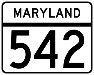
Maryland Route 542 is a state highway in the U.S. state of Maryland. Known for most of its length as Loch Raven Boulevard, the state highway runs 6.33 miles (10.19 km) from MD 147 in Baltimore north to Interstate 695 (I-695) and Cromwell Bridge Road near Towson. MD 542 is a four-lane divided highway that connects portions of Northeast Baltimore with Towson and I-695. The state highway is maintained by the Maryland State Highway Administration in Baltimore County and the Baltimore City Department of Transportation in the city. MD 542 was constructed in the early to mid-1930s. The highway was expanded to a divided highway in Baltimore by 1950 and in Baltimore County in the mid- to late 1950s.
Old Harford Road, one of the oldest continuously used rights-of-way in central Maryland, United States, is a southwest–northeast thoroughfare in northeast Baltimore City and eastern Baltimore County.

Glen Arm is an unincorporated community in Baltimore County, Maryland, United States. Glen Arm lies along what is now Glen Arm Road, which was once part of Old Harford Road, one of the early routes used for conveying agricultural products from parts of Harford and Baltimore Counties and southern Pennsylvania to the port of Baltimore. Glen Arm was also served until 1958 by the Maryland and Pennsylvania Railroad. In 1921, at the railroad's crossing of Glen Arm Road, what generally is recognized as the nation's first train-actuated railroad crossing signal was installed by the railroad's Superintendent of Signals Charles Adler, Jr. Adler later designed early traffic-actuated traffic lights for the City of Baltimore, and also invented the system of flashing warning lights used on aircraft.
