
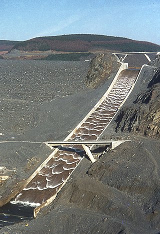
Dartmouth Dam is a large rock-fill embankment dam with an uncontrolled chute spillway across the Mitta Mitta, Gibbo and Dart rivers, the Morass Creek and a number of small tributaries. The dam is located near Mount Bogong in the north-east of the Australian state of Victoria. The dam's purpose includes irrigation, the generation of hydro-electric power, water supply and conservation. The impounded reservoir is called Dartmouth Reservoir, sometimes called Lake Dartmouth. The Dartmouth Power Station, a hydro-electric power station that generates power to the national grid, is located near the dam wall.

Lake Travis is a reservoir on the Colorado River in central Texas in the United States. It is named in honor of William B. Travis.

Flamborough is a community in the city of Hamilton in the Canadian province of Ontario. Prior to its amalgamation in 2001, Flamborough comprised the former townships of East Flamborough, West Flamborough, and Beverly, as well as the village of Waterdown. The largest suburban community is the former village of Waterdown, containing one third of the population. Other Flamborough communities include Carlisle, Christie's Corners, Clappison's Corners, Copetown, Freelton, Greensville, Lynden, Kirkwall, Millgrove, Mountsberg, Orkney, Peters Corners, Rockton, Troy, Sheffield, Valens, Strabane and Westover.
A spillway is a structure used to provide the controlled release of water downstream from a dam or levee, typically into the riverbed of the dammed river itself. In the United Kingdom, they may be known as overflow channels. Spillways ensure that water does not damage parts of the structure not designed to convey water.

Waterdown is a community in the city of Hamilton in the Canadian province of Ontario. Waterdown is approximately 60 km west of downtown Toronto and, as of 2021, has a population of approximately 24,400 residents.
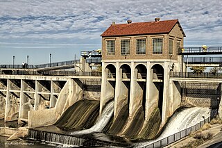
Lake Overholser is a reservoir within the city limits of Oklahoma City, Oklahoma. Lake Overholser is formed by Overholser Dam on the North Canadian River in Oklahoma County, Oklahoma. The lake is 2.9 miles (4.7 km) west of Bethany and 4.4 mi (7.1 km) from Yukon. Lake Overholser is named after Ed Overholser who was the 16th Mayor of the City of Oklahoma City.

Glanbrook is the south-western district of the city of Hamilton, Ontario, Canada. It was first created as an independent township in 1974 through the amalgamation of Mount Hope, Binbrook, Glanford, and other nearby communities. In 2001, Glanbrook became a dissolved municipality after it was amalgamated with Hamilton, Stoney Creek, Dundas, Ancaster and Flamborough to become the present city of Hamilton.

Burrendong Dam is a rock-fill embankment major gated dam with a clay core across the Macquarie River upstream of Wellington in the central west region of New South Wales, Australia. The dam's purpose includes flood mitigation, irrigation, water supply and hydro-electric power generation. The dam impounds Lake Burrendong and is filled by the waters from the Macquarie, and Cudgegong rivers as well as Meroo Creek.
The Hamilton Conservation Authority maintains the greenspace, trails, parks and some attractions in Hamilton, Ontario, Canada.

Canyon Lake is a reservoir on the Guadalupe River in the Texas Hill Country in the United States. Canyon Lake is a U.S. Army Corps of Engineers reservoir formed on the Guadalupe River in Comal County by Canyon Dam, which is located about sixteen miles northwest of New Braunfels. The dam, lake, and all adjacent property are managed by the U.S. Army Corps Of Engineers. Water rights, waste water treatment, and hydroelectric generating facilities are managed by the Guadalupe-Blanco River Authority. Construction of the dam began in 1958 and was completed in 1964. The reservoir serves to provide flood control and water supply for the communities downstream from the dam. The lake is also a popular recreational destination.

Wright Patman Lake is a reservoir in northeast Texas in the United States. The lake is a U.S. Army Corps of Engineers reservoir formed on the Sulphur River in Bowie and Cass counties by Wright Patman Dam. The reservoir provides flood control and water conservation for the communities downstream from the dam. The lake is also a popular recreational destination. The Bowie County side of the lake is part of the Texarkana metropolitan area.

Benbrook Lake is a reservoir on the Clear Fork of the Trinity River in Tarrant County, Texas, USA. The lake is located approximately 10 miles (16 km) southwest of the center of Fort Worth, where the Clear Fork and the West Fork of the Trinity River join. The lake is impounded by the Benbrook Dam. The lake and dam are owned and operated by the U.S. Army Corps of Engineers, Fort Worth District.

Mansfield Hollow Lake is a reservoir resting on the border of Windham County and Tolland County, Connecticut. The reservoir provides drinking water for Willimantic and helps control flooding in the 159-square-mile Thames River watershed. It was created by the Mansfield Hollow Dam and is entirely contained within Mansfield Hollow State Park and the Mansfield Hollow Wildlife Area. Designed and constructed by the United States Army Corps of Engineers, the dam substantially reduces flooding along the Quinebaug, Shetucket, and Thames rivers. Construction of the project began in 1949 with completion in 1952 at a cost of US$6.5 million. The Mansfield Hollow reservoir is located within the Shetucket River Watershed and is part of the Thames River Basin. Access to the site is available from US Route 6 and State Route 195. The damsite, covering an area of 25 acres (10 ha), was listed on the National Register of Historic Places in 2003.

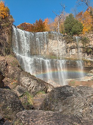
Darnley Cascade is a 4-metre-high (13 ft) cascade waterfall located at Crooks Hollow Conservation Area in Greensville, Hamilton, Ontario, Canada. Nearby attractions include Bruce Trail, Dundas Valley Conservation Area, Spencer Gorge/Webster's Falls Conservation Area, Hermitage ruins, Royal Botanical Gardens, Dundurn Castle, Christie Lake Conservation Area, Dundas Historical Society Museum and Carnegie Gallery.

Santa Fe Dam is a flood-control dam on the San Gabriel River located in Irwindale in Los Angeles County, California, United States. For most of the year, the 92-foot (28 m)-high dam and its reservoir lie empty, but can hold more than 45,000 acre-feet (56,000,000 m3) of water during major storms. During the dry season, the basin behind the dam is used for groundwater recharge, as well as various recreational activities.

Sweetwater Dam is a dam across the Sweetwater River in San Diego County, California. It is located approximately 12 miles (19 km) east of San Diego, 9 miles (14 km) and borders Bonita to the southwest and La Presa to the northeast. The 108-foot (33 m)-high masonry arch dam impounds 960-acre (390 ha) Sweetwater Reservoir.
Morena Dam is a rockfill dam across Cottonwood Creek, a tributary of the Tijuana River in southern San Diego County, California. Originally completed in 1912 and raised several times afterward, the dam is one of the oldest components of the city of San Diego's municipal water system, providing between 1,600 to 15,000 acre-feet of water per year. It is one of the few facilities in the San Diego water supply system that relies entirely on local runoff.

Broken Down Dam was a concrete hydroelectric gravity dam on the Otter Tail River in Otter Tail County, Minnesota in the United States. Constructed in 1908 to supply power to the nearby town of Fergus Falls, the dam suddenly failed on September 24, 1909. Collapse of the dam caused the failure of four others downstream as well as significant property damage. There were no deaths. City officials left the damaged structure in place and today its ruins lie along the recreational Otter Tail River State Water Trail at Broken Down Dam Park. The only flood recorded in the history of Fergus Falls was due to this disaster.
Spencer Dam was a run of the river hydroelectric dam on the Niobrara River in Boyd County and Holt County, Nebraska, about 5 miles (8.0 km) southeast of Spencer. The dam was operated by the Nebraska Public Power District (NPPD). Heavy precipitation during the March 2019 North American blizzard led to a failure of the dam in the early morning of 14 March, causing heavy flooding downstream.

