
Gladstone is a city located in Clackamas County, Oregon, United States. The population was 11,491 at the 2010 census. Gladstone is an approximately 4-square-mile (10 km2) suburban community, 12 miles (19 km) south of Portland, the largest city in Oregon, and located at the confluence of the Clackamas and Willamette rivers.

Hat Head is a national park in New South Wales, Australia, 461.7 kilometres (286.9 mi) via M1 and Pacific Highway/A1, northeast of Sydney. It lies within the Hastings-Macleay Important Bird Area. Within the park is the eponymous village of Hat Head, with about 320 inhabitants.
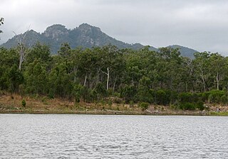
Castle Tower is a national park in the Gladstone Region, Queensland, Australia.

Multnomah Falls is a waterfall located on Multnomah Creek in the Columbia River Gorge, east of Troutdale, between Corbett and Dodson, Oregon, United States. The waterfall is accessible from the Historic Columbia River Highway and Interstate 84. Spanning two tiers on basalt cliffs, it is the tallest waterfall in the state of Oregon at 620 ft (189 m) in height. The Multnomah Creek Bridge, built in 1914, crosses below the falls, and is listed on the National Register of Historic Places.

The Clackamas River is an approximately 83-mile (134 km) tributary of the Willamette River in northwestern Oregon, in the United States. Draining an area of about 940 square miles (2,435 km2), the Clackamas flows through mostly forested and rugged mountainous terrain in its upper reaches, and passes agricultural and urban areas in its lower third. The river rises in eastern Marion County, about 55 miles (89 km) east-southeast of Salem. The headwaters are on the slopes of Olallie Butte in the Mount Hood National Forest, about 10 miles (16 km) north of Mount Jefferson, at an elevation of 4,909 feet (1,496 m) in the Cascade Range. The Clackamas flows briefly north and then flows northwest through the mountains, passing through North Fork Reservoir and Estacada. It then emerges from the mountains southeast of Portland. It joins the Willamette near Oregon City and forms the boundary between Oregon City and Gladstone.

Oregon Route 43 is an Oregon state highway that runs between the cities of Oregon City and Portland, mostly along the western flank of the Willamette River. While it is technically known by the Oregon Department of Transportation as the Oswego Highway No. 3, on maps it is referred to by its route number or by the various street names it has been given.

William Gladstone Steel was an American journalist who was known for campaigning for 17 years for the United States Congress to designate Crater Lake as a National Park. Steel is from Ohio, and worked in the newspaper business before becoming a mail carrier.

Oregon Route 99E is an Oregon state highway that runs between Junction City, Oregon and an interchange with I-5 just south of the Oregon/Washington border, in Portland. It, along with OR 99W, makes up a split of OR 99 in the northern part of the state. This split existed when the route was U.S. Route 99, when the two branches were U.S. 99W and U.S. 99E.

A buffalo jump, or sometimes bison jump, is a cliff formation which Indigenous peoples of North America historically used to hunt and kill plains bison in mass quantities. The broader term game jump refers to a man-made jump or cliff used for hunting other game, such as reindeer.

Tumalo State Park is a well-developed state park in Deschutes County, Oregon, United States. Established in 1954, the park is located northwest of the city of Bend and along the Deschutes River at a site home to many bird species. The park is popular for picnics, swimming, fishing, hiking, and camping, and is open year-round.

Mill Creek Falls, is a waterfall located in the Rogue River Canyon within the Prospect State Scenic Viewpoint in Jackson County, in the U.S. state of Oregon. The waterfall is located at the south end of Mill Creek as it plunges into the Rogue River over a carved cliff surrounded by walls of petrified volcanic ash consequence of Mount Mazama eruption.

The Sinnott Memorial Observation Station is a sheltered viewpoint built into the caldera cliff 900 feet above Crater Lake in southern Oregon, United States. It is located near the Rim Village Visitor Center in Crater Lake National Park. The structure includes a small natural history museum with exhibits that highlight the geologic history of Mount Mazama and the formation of Crater Lake. The building was officially dedicated as the Nicholas J. Sinnott Memorial Observation Station and Museum; however, it is commonly known as the Sinnott Memorial Overlook or Sinnott Viewing Area. It is architecturally significant because it was the first National Park Service building constructed specifically as a museum and the first structure built in Crater Lake National Park using rustic stone masonry construction. It is listed on the National Register of Historic Places as Sinnott Memorial Building No. 67.
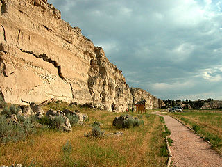
Register Cliff is a sandstone cliff and featured key navigational landmark prominently listed in the 19th century guidebooks about the Oregon Trail, and a place where many emigrants chiseled the names of their families on the soft stones of the cliff — it was one of the key checkpoint landmarks for parties heading west along the Platte River valley west of Fort John, Wyoming which allowed travelers to verify they were on the correct path up to South Pass and not moving into impassable mountain terrains—geographically, it is on the eastern ascent of the Continental divide leading upward out of the great plains in the east of the U.S. state of Wyoming. It is notable as a historic landmark for 'registering' hundreds of emigrants on the Oregon Trail who came to follow custom and inscribed their names on its rocks during the western migrations of the 19th century. An estimated 500,000 emigrants used these trails from 1843 to 1869, with up to one-tenth dying along the way, usually due to disease.
The 1960 NCAA Track and Field Championships were held in Berkeley, California in June 1960. The University of Kansas won the team title for the second consecutive year. Ten NCAA meet records were broken, and one was tied.

Madison Buffalo Jump State Park is a Montana state park located seven miles south of the Interstate 90 interchange at Logan in Gallatin County, Montana in the United States. The park preserves a canyon cliff used by Native Americans as a buffalo jump, where herds of bison were stampeded over the cliff as an efficient means of slaughter. The main geographic features of the jump site remain largely unchanged since the days of the jumps. Archaeologists have found tons of bison bones buried at the base of the cliffs. They have also uncovered the remains of tipi villages.

Nye Beach is a central district in Newport in the U.S. state of Oregon. The Nye Beach historic overlay district is bounded on the north and south sides by Northwest Twelfth Street and Southwest Second Street respectively; on the east side by Hurbert Street and on the west side by the Pacific Ocean. Situated on a sea cliff, the district has been a popular vacation spot since the late 19th century. Cultural and literary groups such as Oregon Coast Council for the Arts, Yaquina Art Association, and Writers on the Edge are based in Nye Beach, as are Newport's Performing Arts and Visual Arts Centers. The beach attracts tide-pool enthusiasts and beachcombers as well as surfers, sail-boarders, crabbers, clam diggers, kite flyers, photographers, and artists and has also been the site of marine and geological research projects.

Cottonwood Canyon State Park, established in 2013, is the second largest state park in Oregon, encompassing 8,000 acres (3,200 ha) on the lower John Day River. The largest is Silver Falls State Park at 9,064 acres (3,668 ha).

The 1959 NCAA Skiing Championships were contested in Winter Park, Colorado at the sixth annual NCAA-sanctioned ski tournament to determine the individual and team national champions of men's collegiate alpine skiing, cross-country skiing, and ski jumping in the United States.
Gladstone Nature Park is a park in Gladstone, Oregon, United States.

