In mathematics, analytic geometry, also known as coordinate geometry or Cartesian geometry, is the study of geometry using a coordinate system. This contrasts with synthetic geometry.

In mathematics, the slope or gradient of a line is a number that describes both the direction and the steepness of the line. Slope is often denoted by the letter m; there is no clear answer to the question why the letter m is used for slope, but its earliest use in English appears in O'Brien (1844) who wrote the equation of a straight line as "y = mx + b" and it can also be found in Todhunter (1888) who wrote it as "y = mx + c".

Highway engineering is an engineering discipline branching from civil engineering that involves the planning, design, construction, operation, and maintenance of roads, bridges, and tunnels to ensure safe and effective transportation of people and goods. Highway engineering became prominent towards the latter half of the 20th century after World War II. Standards of highway engineering are continuously being improved. Highway engineers must take into account future traffic flows, design of highway intersections/interchanges, geometric alignment and design, highway pavement materials and design, structural design of pavement thickness, and pavement maintenance.

The grade of a physical feature, landform or constructed line refers to the tangent of the angle of that surface to the horizontal. It is a special case of the slope, where zero indicates horizontality. A larger number indicates higher or steeper degree of "tilt". Often slope is calculated as a ratio of "rise" to "run", or as a fraction in which run is the horizontal distance and rise is the vertical distance.

Macadam is a type of road construction, pioneered by Scottish engineer John Loudon McAdam around 1820, in which crushed stone is placed in shallow, convex layers and compacted thoroughly. A binding layer of stone dust may form; it may also, after rolling, be covered with a cement or bituminous binder to keep dust and stones together. The method simplified what had been considered state-of-the-art at that point.

Aquaplaning or hydroplaning by the tires of a road vehicle, aircraft or other wheeled vehicle occurs when a layer of water builds between the wheels of the vehicle and the road surface, leading to a loss of traction that prevents the vehicle from responding to control inputs. If it occurs to all wheels simultaneously, the vehicle becomes, in effect, an uncontrolled sled. Aquaplaning is a different phenomenon from when water on the surface of the roadway merely acts as a lubricant. Traction is diminished on wet pavement even when aquaplaning is not occurring.
Standards for Interstate Highways in the United States are defined by the American Association of State Highway and Transportation Officials (AASHTO) in the publication A Policy on Design Standards: Interstate System. For a certain highway to be considered an Interstate Highway, it must meet these construction requirements or obtain a waiver from the Federal Highway Administration.

Roof pitch is the steepness of a roof expressed as a ratio of inch(es) rise per horizontal foot, or as the angle in degrees its surface deviates from the horizontal. A flat roof has a pitch of zero in either instance; all other roofs are pitched.
A banked turn is a turn or change of direction in which the vehicle banks or inclines, usually towards the inside of the turn. For a road or railroad this is usually due to the roadbed having a transverse down-slope towards the inside of the curve. The bank angle is the angle at which the vehicle is inclined about its longitudinal axis with respect to the horizontal.

A track transition curve, or spiral easement, is a mathematically-calculated curve on a section of highway, or railroad track, in which a straight section changes into a curve. It is designed to prevent sudden changes in lateral acceleration. In plane, the start of the transition of the horizontal curve is at infinite radius, and at the end of the transition, it has the same radius as the curve itself and so forms a very broad spiral. At the same time, in the vertical plane, the outside of the curve is gradually raised until the correct degree of bank is reached.

A curb, or kerb, is the edge where a raised sidewalk or road median/central reservation meets a street or other roadway.
Landslide mitigation refers to several man-made activities on slopes with the goal of lessening the effect of landslides. Landslides can be triggered by many, sometimes concomitant causes. In addition to shallow erosion or reduction of shear strength caused by seasonal rainfall, landslides may be triggered by anthropic activities, such as adding excessive weight above the slope, digging at mid-slope or at the foot of the slope. Often, individual phenomena join together to generate instability over time, which often does not allow a reconstruction of the evolution of a particular landslide. Therefore, landslide hazard mitigation measures are not generally classified according to the phenomenon that might cause a landslide. Instead, they are classified by the sort of slope stabilization method used:

In railway engineering, cant deficiency is defined in the context of travel of a rail vehicle at constant speed on a constant-radius curve. Cant itself refers to the superelevation of the curve, that is, the difference between the elevations of the outside and inside rails. Cant deficiency is present when a rail vehicle's speed on the curve is greater than the speed at which the components of wheel to rail force are normal to the plane of the track. In that case, the resultant force exerts on the outside rail more than the inside rail, in which it creates lateral acceleration toward the outside of the curve. In order to reduce cant deficiency, the speed can be reduced or the superelevation can be increased. The amount of cant deficiency is expressed in terms of required superelevation to be added in order to bring the resultant force into balance between the two rails.

Road slipperiness is a condition of low skid resistance due to insufficient road friction. It is a result of snow, ice, water, loose material and the texture of the road surface on the traction produced by the wheels of a vehicle.

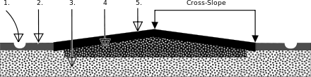
Drainage gradient (DG) is a term in road design, defined as the combined slope due to road surface cross slope (CS) and longitudinal slope (hilliness). Although the term may not be used, the concept is also used in roof design and landscape architecture.
Road surface textures are deviations from a planar and smooth surface, affecting the vehicle/tyre interaction. Pavement texture is divided into: microtexture with wavelengths from 0 mm to 0.5 millimetres (0.020 in), macrotexture with wavelengths from 0.5 millimetres (0.020 in) to 50 millimetres (2.0 in) and megatexture with wavelengths from 50 millimetres (2.0 in) to 500 millimetres (20 in).

The geometric design of roads is the branch of highway engineering concerned with the positioning of the physical elements of the roadway according to standards and constraints. The basic objectives in geometric design are to optimize efficiency and safety while minimizing cost and environmental damage. Geometric design also affects an emerging fifth objective called "livability," which is defined as designing roads to foster broader community goals, including providing access to employment, schools, businesses and residences, accommodate a range of travel modes such as walking, bicycling, transit, and automobiles, and minimizing fuel use, emissions and environmental damage.

Crocodile cracking, also called alligator cracking and perhaps misleadingly fatigue cracking, is a common type of distress in asphalt pavement. The following is more closely related to fatigue cracking which is characterized by interconnecting or interlaced cracking in the asphalt layer resembling the hide of a crocodile. Cell sizes can vary in size up to 11.80 inches (300 mm) across, but are typically less than 5.90 inches (150 mm) across. Fatigue cracking is generally a loading failure, but numerous factors can contribute to it. It is often a sign of sub-base failure, poor drainage, or repeated over-loadings. It is important to prevent fatigue cracking, and repair as soon as possible, as advanced cases can be very costly to repair and can lead to formation of potholes or premature pavement failure.

Track geometry is concerned with the properties and relations of points, lines, curves, and surfaces in the three-dimensional positioning of railroad track. The term is also applied to measurements used in design, construction and maintenance of track. Track geometry involves standards, speed limits and other regulations in the areas of track gauge, alignment, elevation, curvature and track surface. Standards are usually separately expressed for horizontal and vertical layouts although track geometry is three-dimensional.

The cant of a railway track or camber of a road is the rate of change in elevation (height) between the two rails or edges. This is normally greater where the railway or road is curved; raising the outer rail or the outer edge of the road creates a banked turn, thus allowing vehicles to maneuver through the curve at higher speeds than would otherwise be possible were the surface flat or level.