
Bangor is a city in the U.S. state of Maine and the county seat of Penobscot County. The city proper has a population of 33,039, making it the state's 3rd-largest settlement, behind Portland (66,882) and Lewiston (36,221).

Addison is a town in Washington County, Maine, United States. The town was named after English author Joseph Addison. The population was 1,266 as of the 2010 census.

Biddeford is a city in York County, Maine, United States. It is the principal commercial center of York County. The population was 21,277 at the 2010 census. Twin city of Saco, Biddeford includes the resort community of Biddeford Pool, Fortunes Rocks and Granite Point. The town is the site of the University of New England and the annual La Kermesse Franco-Americaine Festival. First visited by Europeans in 1616, it is the site of one of the earliest European settlements in the United States.
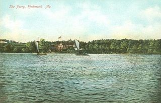
Perkins Township is an unorganized territory in Sagadahoc County, Maine, United States. Originally incorporated as the town of Perkins, it has been uninhabited since being abandoned by the 1940s. The township comprises Swan Island, Little Swan Island and some tidal flats - all within the Kennebec River between the towns of Richmond and Dresden. The Swan Island Historic District comprises most of the township, with 8 buildings, 5 structures and 1,500 acres (610 ha). Some of the buildings date to the 1750s. The district was added to the National Register of Historic Places in 1995. The entire township is now protected as the Steve Powell Wildlife Management Area, and is under the jurisdiction of the Maine Department of Inland Fisheries and Wildlife. Camping, hunting, fishing, and wildlife viewing are permitted between May and October; reservations are required.

Crowley's Ridge is a geological formation that rises 250 to 550 feet (170 m) above the alluvial plain of the Mississippi embayment in a 150-mile (240 km) line from southeastern Missouri to the Mississippi River near Helena, Arkansas. It is the most prominent feature in the Mississippi Alluvial Plain between Cape Girardeau, Missouri, and the Gulf of Mexico.

Casco Bay is an inlet of the Gulf of Maine on the southern coast of Maine, New England, United States. Its easternmost approach is Cape Small and its westernmost approach is Two Lights in Cape Elizabeth. The city of Portland sits along its southern edge and the Port of Portland lies within.

Machias Seal Island is an island in disputed water between the Gulf of Maine and the Bay of Fundy, about 16 km (10 mi) southeast from Cutler, Maine, and 19 km (12 mi) southwest of Grand Manan Island, New Brunswick. Sovereignty of the island is disputed by the US and Canada. The Canadian Coast Guard continues to staff a lighthouse on the island; the first lighthouse was constructed there in 1832.

The Gulf of Maine is a large gulf of the Atlantic Ocean on the east coast of North America. It is bounded by Cape Cod at the eastern tip of Massachusetts in the southwest and by Cape Sable Island at the southern tip of Nova Scotia in the northeast. The gulf includes the entire coastlines of the U.S. states of New Hampshire and Maine, as well as Massachusetts north of Cape Cod, and the southern and western coastlines of the Canadian provinces of New Brunswick and Nova Scotia, respectively.
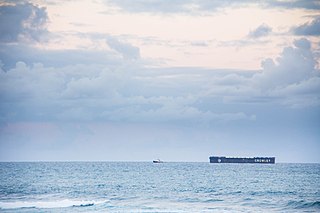
Crowley Maritime Corporation, is based in Jacksonville, Florida. Founded in 1892, Crowley is primarily a family- and employee-owned vessel management, owner, and supply chain logistics services company, providing services globally. As of July 2016, Crowley was ranked as the 13th largest private company in Florida, employing approximately 5,300 people worldwide with revenues of $2.2 billion. It provides its services using a fleet of more than 300 vessels, consisting of RO-RO vessels, LO-LO vessels, tankers, Articulated Tug-Barges (ATBs), tugs and barges. Crowley's land-based facilities and equipment include terminals, warehouses, tank farms, and specialized vehicles.
In the U.S. state of Maine, U.S. Route 2 (US 2) is a principal east–west route through the central portion of the state, extending from the New Hampshire border in Gilead to the town of Houlton near the Canadian border.

U.S. Route 50 in West Virginia runs from the border with Ohio to Virginia, passing briefly through Garrett County, Maryland, and following the Northwestern Turnpike. Prior to the U.S. Highway System it was West Virginia Route 1 and in the 1930s, the road was not finished in Maryland. Today the section of US 50 from Clarksburg to Parkersburg on the Ohio River is part of Corridor D of the Appalachian Development Highway System.
Crouseville is an unincorporated village located within the town of Washburn in Aroostook County, Maine, United States.
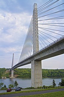
The Penobscot Narrows Bridge is a 2,120 feet (646 m) long cable-stayed bridge that carries US 1/SR 3 over the Penobscot River. It connects Verona Island to Prospect, in the U.S. state of Maine. It replaced the Waldo–Hancock Bridge, built in 1931.
Machias Bay is a bay in Washington County, Maine that opens into the Gulf of Maine. The bay was the scene of the Battle of Machias — the first naval battle of the American Revolution, occasioned by the British need for lumber for Boston.

The Maine Central Railroad Rumford Branch is a railroad line in Maine now operated as part of the Pan Am Railways system. The Rumford Branch leaves the mainline at Leeds Junction and continues northwest up the Androscoggin River valley, passing through Livermore Falls and terminating at Rumford. The branch comprises the remaining trackage of three earlier branches:

Robert Crowley is a former teacher and reality TV personality, known for winning Survivor: Gabon, the seventeenth season of the American TV series Survivor, in 2008. In addition to his million dollar prize, Crowley also won $100,000 from the "player of the season" poll. As of 2019, he was the oldest winner in the history of US Survivor, triumphing at the age of 57.

The Sheepscot River is a 66-mile-long (106 km) river in the U.S. state of Maine. Its lower portion is a complex island estuary with connections to the Kennebec River downstream of Merrymeeting Bay.

Little River Light is a lighthouse on an island at the mouth of the Little River, in Cutler, Maine. A light station was first established at this site in 1846, and the present structure was built in 1876. It is one of the only iron lighthouses in the state, and was listed on the National Register of Historic Places as Little River Light Station on March 14, 1988. The light station is now owned by the American Lighthouse Foundation, which offers overnight stays in the keeper's house, and occasional tours of the property.

Yarmouth is a town in Cumberland County, Maine, located twelve miles north of the state's largest city, Portland. The town was settled, while a district of Massachusetts, in 1636 and incorporated in 1849, 29 years after its admittance to the Union. Its population was 8,349 in the 2010 census. As of 2018's estimation of 8,518, this is about 0.6% of Maine's total population. Five islands are part of the town.

