Related Research Articles
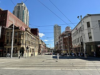
Haymarket is an inner city suburb of Sydney, New South Wales, Australia. It is located at the southern end of the Sydney central business district in the local government area of the City of Sydney. Haymarket includes much of Sydney's Chinatown, Thaitown and Railway Square localities. Haymarket is adjacent to Darling Harbour and is surrounded by the suburbs of Ultimo, Chippendale, Surry Hills and the Sydney CBD.

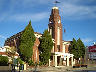
Lane Cove is a suburb on the Lower North Shore of Sydney, New South Wales, Australia. Lane Cove is nine kilometres north-west of the Sydney central business district and is the administrative centre for the local government area of the Lane Cove Council. Lane Cove West and Lane Cove North are separate suburbs.

North Sydney is a suburb and major commercial district on the Lower North Shore of Sydney, New South Wales, Australia. It is located three kilometres north of the Sydney central business district and is the administrative centre for the local government area of North Sydney Council.

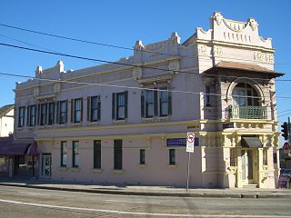
Crows Nest is a suburb on the lower North Shore of Sydney, New South Wales, Australia. It is also part of the North Sydney region, 5 kilometres north of the Sydney central business district, in the local government area of North Sydney Council.

Chippendale is a small inner-city suburb of Sydney, New South Wales, Australia on the southern edge of the Sydney central business district, in the local government area of the City of Sydney. Chippendale is located between Broadway to the north and Cleveland Street to the south, Central railway station to the east and the University of Sydney to the west.
Petersham is a suburb in the Inner West of Sydney, in the state of New South Wales, Australia. Petersham is located 6 kilometres south-west of the Sydney central business district, in the local government area of Inner West Council. Petersham is known for its extensive Portuguese commercial offerings, with many Portuguese businesses and restaurants, although only 156 (1.9%) of the population was actually born in Portugal.

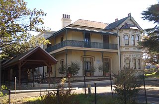
Woollahra is a suburb in the Eastern Suburbs of Sydney, in the state of New South Wales, Australia. Woollahra is located 5 kilometres east of the Sydney central business district, in the local government area of the Municipality of Woollahra. Woollahra is located on the traditional land of the Birrabirragal and Gadigal people of the Eora Nation. The Municipality of Woollahra takes its name from the suburb but its administrative centre is located in Double Bay. Woollahra is famous for its quiet, tree-lined residential streets and village-style shopping centre.
Artarmon is a suburb on the lower North Shore of Sydney, in the state of New South Wales, Australia, 9 kilometres north-west of the Sydney central business district, in the local government area of the City of Willoughby.
Cammeray is a residential suburb located five kilometres north of the Sydney Central Business District (CBD) and is part of the North Sydney Council local government area. Cammeray is part of the Lower North Shore region of Northern Sydney.

Edgecliff is a small suburb in the Eastern Suburbs of Sydney, in the state of New South Wales, Australia. Edgecliff is located 4 kilometres east of the Sydney central business district, in the local government area of the Municipality of Woollahra. The postcode is 2027.

Willoughby is a suburb located on the lower North Shore of Sydney, in the state of New South Wales, Australia 8 kilometres north of the Sydney central business district, in the local government area of the City of Willoughby.
Turrella (;) is a suburb in southern Sydney, in the state of New South Wales, Australia. Turrella is located 10 km south-west of the Sydney central business district on the southern bank of Wolli Creek in the local government area of Bayside Council.

Darling Point is a harbourside eastern suburb of Sydney, Australia. It is 4 kilometres east of the Sydney central business district and is part of the local government area of Woollahra Council.
Enmore is a suburb in the Inner West of Sydney, in the state of New South Wales, Australia. Enmore is located 5 kilometres (3.1 mi) south-west of the Sydney central business district and is part of the local government area of Inner West Council. Like Newtown, Enmore is mostly comprises Victorian era buildings, namely in its commercial area, that provide a hint of the suburb's rich cultural heritage.

White Bay is a bay on Sydney Harbour with a surrounding locality near the suburbs of Balmain and Rozelle in the Inner West of Sydney, New South Wales, Australia.

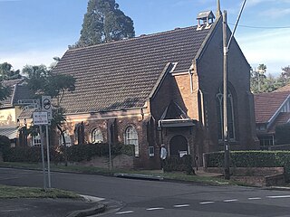
Matcham is a semi-rural suburb of the Central Coast region of New South Wales, Australia. It is part of the Central Coast Council local government area and included in the electoral district of Terrigal. It has a hall and a historic church, St. George's Church, established in 1925.
Point Clare is a suburb of the Central Coast region of New South Wales, Australia located approximately 75 kilometres (47 mi) north of Sydney and 4 kilometres (2 mi) south-west of Gosford's central business district on the western shore of Brisbane Water. It is part of the Central Coast Council local government area.

Wentworth Point is a suburb of Sydney, in the state of New South Wales, Australia. It is located 13 kilometres west of the Sydney central business district, on the eastern edge of the local government area of City of Parramatta. It is on the western shore of Homebush Bay on the southern side of the Parramatta River. Wentworth Point is usually regarded as part of the Greater Western Sydney region, including in administrative contexts, but it is also regarded as part of the Inner West region of Sydney in some contexts, especially commercial contexts.
Mosman High School, is a school located in Mosman, a suburb of Sydney, Australia, on Military Road. It is a co-educational high school operated by the New South Wales Department of Education with students from years 7 to 12. The school was established in 1961 and is one of the few state schools in NSW that has no school uniform.
Crows Nest Boys High School is a former high school located at 365 Pacific Highway in the Sydney suburb of Crows Nest, New South Wales, Australia. It was a boys' high school operated by the New South Wales Department of Education with students from years 7 to 12. The school was first established in 1883 as St Leonards North Public School. However, the school was declared surplus to the needs of the department and officially closed in 1992. The school and its heritage-listed buildings are now the campus of North Sydney Girls High School.
References
- ↑ "Crows Nest Fire Station". Fire and Rescue New South Wales. 2023. Retrieved 10 January 2024.
- ↑ "Crows Nest Fire Station, 99 Shirley Rd, Crows Nest, NSW, Australia - listing on the now-defunct Register of the National Estate (Place ID 2910)". Australian Heritage Database . Australian Government . Retrieved 11 November 2018.
- ↑ "Crow's Nest Fire Station". Sydney Morning Herald . 20 February 1907.