
The Dolomites, also known as the Dolomite Mountains, Dolomite Alps or Dolomitic Alps, are a mountain range located in northeastern Italy. They form part of the Southern Limestone Alps and extend from the River Adige in the west to the Piave Valley in the east. The northern and southern borders are defined by the Puster Valley and the Sugana Valley. The Dolomites are located in the regions of Veneto, Trentino-Alto Adige/Südtirol and Friuli Venezia Giulia, covering an area shared between the provinces of Belluno, Vicenza, Verona, Trentino, South Tyrol, Udine and Pordenone.
The term "Trekking Peak" is a commonly misunderstood colloquial term which may refer to a variety of types of peaks in the Himalayan Region. The term is most often associated with Group "B" NMA Climbing Peaks classified by the Nepal Mountaineering Association or easier. Some may use the term "Trekking Peak" to solely describe peaks requiring little to no technical climbing experience. Others may use the term to describe all mountains regulated by the Nepal Mountaineering Association including Group "A" NMA Expedition Peaks which may require considerable difficulties and technical climbing skill.

Bassano del Grappa is a city and comune, in the Vicenza province, in the region of Veneto, in northern Italy. It bounds the communes of Cassola, Marostica, Solagna, Pove del Grappa, Romano d'Ezzelino, Campolongo sul Brenta, Conco, Rosà, Cartigliano and Nove. Some neighbourhoods of these communes have become in practice a part of the urban area of Bassano, so that the population of the whole conurbation totals around 70,000 people.
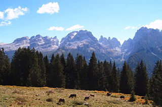
The Brenta Group or Brenta Dolomites is a mountain range, and a subrange of the Rhaetian Alps in the Southern Limestone Alps mountain group. They are located in the Province of Trentino, in northeastern Italy. It is the only dolomitic group west of the Adige River. Therefore, geographically, they have not always been considered a part of the Dolomites mountain ranges. Geologically, however, they definitely are - and therefore sometimes called the "Western Dolomites". As part of the Dolomites, the Brenta Group has been officially recognized as UNESCO World Heritage Site under the World Heritage Convention.

The Mala del Brenta, also known as Mafia veneta or Mafia del Piovese, is an organized crime group based in the Veneto and Friuli-Venezia Giulia, north-eastern Italy.

The Riviera del Brenta is an area of the Metropolitan City of Venice of particular tourist-cultural interest due to the great architectural heritage of the Venetian villas built between the 15th and 18th centuries by the nobles of the Venetian Republic along the river Brenta.

The Sole Valley is a valley in Trentino, northern Italy.

Molveno is a comune (municipality) in Trentino in the northern Italian region of Trentino-Alto Adige/Südtirol, located about 40 kilometres (25 mi) northwest of Trento. It is famous for its positioning on Lake Molveno as a holiday destination, its nearby ski resorts (Andalo-Paganella) and its connection to the National Park Adamello Brenta.

The Ponte Vecchio or Ponte degli Alpini is the covered wooden pontoon bridge designed by the architect Andrea Palladio in 1569. The bridge is located in Bassano del Grappa and was destroyed many times, the last time in World War II. The bridge spans the river Brenta.

Francis Fox Tuckett FRGS was an English mountaineer. He was vice-president of the Alpine Club from 1866 to 1868, and a Fellow of the Royal Geographical Society.

Przemysław Niemiec is a Polish former road racing cyclist, who rode professionally between 2002 and 2018 for the Amore & Vita–Beretta, Miche and UAE Team Emirates squads.

Riccardo Cassin was an Italian mountaineer, developer of mountaineering equipment and author.
Cima Dodici is a mountain on the border of Vicenza in Veneto and Trentino in Trentino Alto Adige, northern Italy, south of the village of Borgo Valsugana. It has an elevation of 2,336 metres. and is the highest peak in Vicenza. At 1,874 m prominence, it is an ultra prominent peak. The key col is near the village of Pergine Valsugana.

The Messner Mountain Museum (MMM) is a museum project created in 2006 by Italian mountaineer and extreme climber Reinhold Messner in South Tyrol in northern Italy. Messner's museum project is designed to educate visitors on "man's encounter with mountains" and deals with the science of mountains and glaciers, the history of mountaineering and rock climbing, the history of mythical mountains, and the history of mountain-dwelling people.
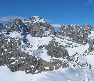
Campanile Basso is a mountain in the Brenta group, a subgroup of the Rhaetian Alps in the Italian Region of Trentino-Alto Adige, with a height of. It is of a slender, almost fully vertical shape on all sides, rising 300 metres straight up. The mountain is named for its similarity in shape to a belltower and it being low compared to the neighboring Campanile Alto and Brenta Alta. The German alpinist Karl Schulz introduced in 1884 the name Guglia di Brenta, a name widely used until World War I and especially enduring in German literature, but considered inappropriate by locals and Italian climbers. Geologically, Campanile Basso is entirely formed of Triassic sedimentary rock, dense and compact dolomite. Due to its inaccessible appearance it was long left untouched during the alpine exploration of the Eastern Alps. Around the turn of the century a competitive race for the first ascent started, which took inspiration from the emerging nationalistic feelings in the region, as much as from the ascent of rock climbing as a sport. Most of the illustrious forebears of modern rock climbing climbed this mountain during the first half of the Twentieth century.
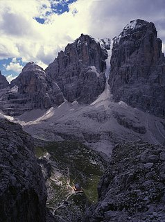
Cima Tosa is a mountain in the Brenta group, a subgroup of the Rhaetian Alps in the Italian Region of Trentino-Alto Adige, with a reported height of 3,136 metres (10,289 ft). it is the second highest peak of the Brenta group in the southern limestone Alps after the Cima Brenta.
Cima Brenta is the highest mountain in the Brenta group, a subgroup of the Rhaetian Alps in the Italian Region of Trentino-Alto Adige, with a reported height of 3,150 metres (10,330 ft). The mountain rises imposingly up between the rock towers and pinnacles of the central Brenta Group. A sharp ridge connects the mountain on its southern side to the Spallone die Massodi. The northern ridge steeply descends towards Bocca del Tuckett. Towards north west a slender couloir descends all the way from the top towards the Vedretta di Brenta Inferiore, the mountain's 'lower' glacier. Large shouldering formations extend towards the west, culminating in the Cima Mandrone and the Punti di Campiglio, and northwest, culminating in the Cima Massari. Above these formations a glacier, the Vedretta di Brenta Superiore, the 'upper' glacier descends the mountain, being cut off by a vertical precipice over the Vedretta di Brenta Inferiore. On the eastern side the mountain rises up with an imposing 700-meter high vertical rock face with on its left side a distinct orange-like color. Above this lies a horizontal ledge, the Cengia Garbari, on which the Via delle Bocchette Alte proceeds. The actual mountain has two summits that are some 250 meters apart, of which the eastern top reaches the highest altitude. The glaciers, vedrette, have been shrinking steadily over the last decades as a result of climate change. The historical name Cima Brenta was not always as evident as it is today. The toponymy of these parts was largely established by Nepomuceno Bolognini. The mountain, somehow, became a place where nationalistic sentiments were demonstrated. In 1889 the Austro-Hungarian authorities decided to rename the mountain to Kaiser Franz Josef-Spitze. The name never caught on -not even in German literature. When the occasion occurred to raise a large yellow-black imperial flag on the summit, fully visible from Val Rendena as well as from Molveno, local guide Giuseppe 'Bepaccia' Zeni and some companions climbed the mountain to take it down. In 1912, on the other hand, the Italian flag was hoisted by irredentists on Cima Brenta, deliberately just before the first snow fall, so that the flag remained visible until the next summer. Around 1953 electricity company SISM, predecessor of ENEL proposed to build a cable car trajectory from Molveno to the top of Cima Brenta. The plans were abandoned and in 1967 the mountain became protected as part of the Parco Naturale Adamello-Brenta.
Pit Schubert is a German non-fiction author, climber and mountaineer. He is the founder and former head of the safety commission of the German Alpine Club (DAV).

The Crozzon di Lares is a mountain in Trentino-Alto Adige, Italy. It is located in Val Rendena, Province of Trento.
