
Geophysics is a subject of natural science concerned with the physical processes and physical properties of the Earth and its surrounding space environment, and the use of quantitative methods for their analysis. The term geophysics sometimes refers only to solid earth applications: Earth's shape; its gravitational and magnetic fields; its internal structure and composition; its dynamics and their surface expression in plate tectonics, the generation of magmas, volcanism and rock formation. However, modern geophysics organizations and pure scientists use a broader definition that includes the water cycle including snow and ice; fluid dynamics of the oceans and the atmosphere; electricity and magnetism in the ionosphere and magnetosphere and solar-terrestrial physics; and analogous problems associated with the Moon and other planets.
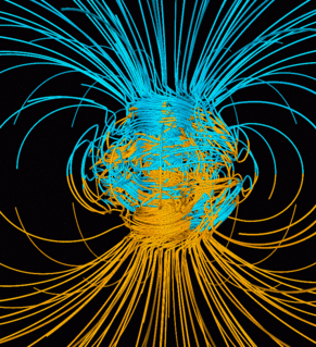
Earth's magnetic field, also known as the geomagnetic field, is the magnetic field that extends from Earth's interior out into space, where it interacts with the solar wind, a stream of charged particles emanating from the Sun. The magnetic field is generated by electric currents due to the motion of convection currents of a mixture of molten iron and nickel in Earth's outer core: these convection currents are caused by heat escaping from the core, a natural process called a geodynamo. The magnitude of Earth's magnetic field at its surface ranges from 25 to 65 μT. As an approximation, it is represented by a field of a magnetic dipole currently tilted at an angle of about 11° with respect to Earth's rotational axis, as if there were an enormous bar magnet placed at that angle through the center of Earth. The North geomagnetic pole actually represents the South pole of Earth's magnetic field, and conversely the South geomagnetic pole corresponds to the north pole of Earth's magnetic field. As of 2015, the North geomagnetic pole was located on Ellesmere Island, Nunavut, Canada.

Lunar Prospector was the third mission selected by NASA for full development and construction as part of the Discovery Program. At a cost of $62.8 million, the 19-month mission was designed for a low polar orbit investigation of the Moon, including mapping of surface composition including polar ice deposits, measurements of magnetic and gravity fields, and study of lunar outgassing events. The mission ended July 31, 1999, when the orbiter was deliberately crashed into a crater near the lunar south pole, after the presence of water ice was successfully detected.

Paleomagnetism, or palaeomagnetism, is the study of the record of the Earth's magnetic field in rocks, sediment, or archeological materials. Magnetic minerals in rocks can lock-in a record of the direction and intensity of the magnetic field when they form. This record provides information on the past behavior of Earth's magnetic field and the past location of tectonic plates. The record of geomagnetic reversals preserved in volcanic and sedimentary rock sequences (magnetostratigraphy) provides a time-scale that is used as a geochronologic tool. Geophysicists who specialize in paleomagnetism are called paleomagnetists.

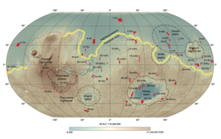
Rock magnetism is the study of the magnetic properties of rocks, sediments and soils. The field arose out of the need in paleomagnetism to understand how rocks record the Earth's magnetic field. This remanence is carried by minerals, particularly certain strongly magnetic minerals like magnetite. An understanding of remanence helps paleomagnetists to develop methods for measuring the ancient magnetic field and correct for effects like sediment compaction and metamorphism. Rock magnetic methods are used to get a more detailed picture of the source of the distinctive striped pattern in marine magnetic anomalies that provides important information on plate tectonics. They are also used to interpret terrestrial magnetic anomalies in magnetic surveys as well as the strong crustal magnetism on Mars.

Terra Sirenum is a large region in the southern hemisphere of the planet Mars. It is centered at 39.7°S 150°W and covers 3900 km at its broadest extent. It covers latitudes 10 to 70 South and longitudes 110 to 180 W. Terra Sirenum is an upland area notable for massive cratering including the large Newton Crater. Terra Sirenum is in the Phaethontis quadrangle and the Memnonia quadrangle of Mars. A low area in Terra Sirenum is believed to have once held a lake that eventually drained through Ma'adim Vallis.

Terra Cimmeria is a large Martian region, centered at 34.7°S 145°E and covering 5,400 km (3,400 mi) at its broadest extent. It covers latitudes 15 N to 75 S and longitudes 170 to 260 W. It lies in the Eridania quadrangle. Terra Cimmeria is one part of the heavily cratered, southern highland region of the planet. The Spirit rover landed near the area.

The magnetic field of the Moon is very weak in comparison to that of the Earth; the major difference is the Moon does not have a dipolar magnetic field currently, so that the magnetization present is varied and its origin is almost entirely crustal in location; so it's difficult to compare as a percentage to Earth. But, one experiment discovered that lunar rocks formed 1 - 2.5 billion years ago were created in a field of about 5 microtesla (μT), compared to present day Earth's 50 μT. During the Apollo program several magnetic field strength readings were taken with readings ranging from a low of 6γ (6nT) at the Apollo 15 site to a maximum of 313γ (0.31μT) at the Apollo 16 site, note these readings were recorded in gammas(γ) a now outdated unit of magnetic flux density equivalent to 1nT.
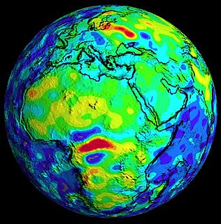
In geophysics, a magnetic anomaly is a local variation in the Earth's magnetic field resulting from variations in the chemistry or magnetism of the rocks. Mapping of variation over an area is valuable in detecting structures obscured by overlying material. The magnetic variation in successive bands of ocean floor parallel with mid-ocean ridges was important evidence for seafloor spreading, a concept central to the theory of plate tectonics.
Polar wander is the motion of a pole in relation to some reference frame. It can be used, for example, to measure the degree to which Earth's magnetic poles have been observed to move relative to the Earth's rotation axis. It is also possible to use continents as reference and observe the relative motion of the magnetic pole relative to the different continents; by doing so, the relative motion of those two continents to each other can be observed over geologic time as paleomagnetism.

The Vine–Matthews–Morley hypothesis, also known as the Morley–Vine–Matthews hypothesis, was the first key scientific test of the seafloor spreading theory of continental drift and plate tectonics. Its key impact was that it allowed the rates of plate motions at mid-ocean ridges to be computed. It states that the Earth's oceanic crust acts as a recorder of reversals in the geomagnetic field direction as seafloor spreading takes place.
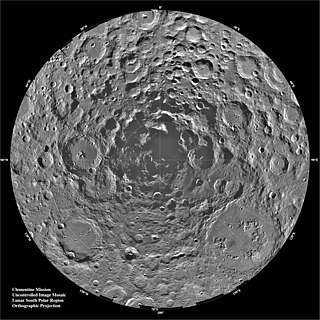
The lunar south pole is the southernmost point on the Moon, at 90°S. It is of special interest to scientists because of the occurrence of water ice in permanently shadowed areas around it. The lunar south pole region features craters that are unique in that the near-constant sunlight does not reach their interior. Such craters are cold traps that contain a fossil record of hydrogen, water ice, and other volatiles dating from the early Solar System. In contrast, the lunar north pole region exhibits a much lower quantity of similarly sheltered craters.
The most conspicuous feature of Mars is a sharp contrast, known as the Martian dichotomy, between the Southern and the Northern hemispheres. The two hemispheres' geography differ in elevation by 1 to 3 km. The average thickness of the Martian crust is 45 km, with 32 km in the northern lowlands region, and 58 km in the southern highlands.
Volcanic activity, or volcanism, has played a significant role in the geologic evolution of Mars. Scientists have known since the Mariner 9 mission in 1972 that volcanic features cover large portions of the Martian surface. These features include extensive lava flows, vast lava plains, and the largest known volcanoes in the Solar System. Martian volcanic features range in age from Noachian to late Amazonian, indicating that the planet has been volcanically active throughout its history, and some speculate it probably still is so today. Both Earth and Mars are large, differentiated planets built from similar chondritic materials. Many of the same magmatic processes that occur on Earth also occurred on Mars, and both planets are similar enough compositionally that the same names can be applied to their igneous rocks and minerals.

The Eridania quadrangle is one of a series of 30 quadrangle maps of Mars used by the United States Geological Survey (USGS) Astrogeology Research Program. The Eridania quadrangle is also referred to as MC-29.
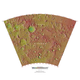
The Phaethontis quadrangle is one of a series of 30 quadrangle maps of Mars used by the United States Geological Survey (USGS) Astrogeology Research Program. The Phaethontis quadrangle is also referred to as MC-24.
Plate reconstruction is the process of reconstructing the positions of tectonic plates relative to each other or to other reference frames, such as the earth's magnetic field or groups of hotspots, in the geological past. This helps determine the shape and make-up of ancient supercontinents and provides a basis for paleogeographic reconstructions.
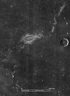
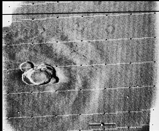
Lunar swirls are enigmatic features found across the Moon's surface, which are characterized by having a high albedo, appearing optically immature, and (often) having a sinuous shape. Their curvilinear shape is often accentuated by low albedo regions that wind between the bright swirls. They appear to overlay the lunar surface, superposed on top of craters and ejecta deposits, but impart no observable topography. Swirls have been identified on the lunar maria and highlands - they are not associated with a specific lithologic composition. Swirls on the maria are characterized by strong albedo contrasts and complex, sinuous morphology, whereas those on highland terrain appear less prominent and exhibit simpler shapes, such as single loops or diffuse bright spots.
The following outline is provided as an overview of and topical guide to geophysics:
Like the Earth, the crustal properties and structure of the surface of Mars are thought to have evolved through time; in other words, as on Earth, tectonic processes have shaped the planet. However, both the ways this change has happened and the properties of the planet's lithosphere are very different when compared to the Earth. Today, Mars is believed to be largely tectonically inactive. However, observational evidence and its interpretation suggests that this was not the case further back in Mars' geological history.
