Related Research Articles

Lake County is a county in the U.S. state of Minnesota. As of the 2010 United States Census, the population was 10,866. Its county seat is Two Harbors.
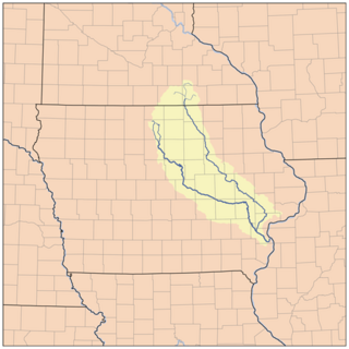
The Cedar River is a 338-mile-long (544 km) river in Minnesota and Iowa. It is a tributary of the Iowa River, which flows to the Mississippi River. The Cedar River takes its name from the red cedar trees growing there, and was originally called the Red Cedar River by the Meskwaki. The first Mississippi steamboat reached Cedar Rapids, Iowa in 1844, and during the next decade, the Red Cedar was an important commercial waterway. The surrounding region is known officially as the Cedar River Valley, though it is more commonly referred to simply as the Cedar Valley.

The Arrowhead Region is located in the northeastern part of the U.S. state of Minnesota, so called because of its pointed shape. The predominantly rural region encompasses 10,635.26 square miles (27,545.2 km2) of land area and includes Carlton, Cook, Lake and Saint Louis counties. Its population at the 2000 census was 248,425 residents. Aitkin, Itasca, and Koochiching counties are also sometimes considered as part of the region. This would increase the land area to 18,221.97 square miles (47,194.7 km2) and the population to 322,073 residents.
The Beaver River is a 23.4-mile-long (37.7 km) river in Lake County, Minnesota. It flows into Lake Superior.

The Caribou River is a 15.0-mile-long (24.1 km) river in northern Minnesota, the United States. It rises in a swamp about .6 miles (1 km) south of Morris Lake and two miles (3.2 km) east of Echo Lake, near the Lake/Cook County line, at an altitude about 1620 feet above sea level. It descends some 1,020 feet in elevation as it flows south to its mouth at Lake Superior, also near the eastern border of Lake County.
The Cross River is a 20.4-mile-long (32.8 km) river in northern Minnesota, the United States. It is a direct tributary of Lake Superior.

The Devil Track River is an 8.7-mile-long (14.0 km) river in northeastern Minnesota, the United States. It begins at the outlet of Devil Track Lake and flows southeast to Lake Superior east of Croftville.
The Little Isabella River is a small stream in Superior National Forest, a United States National Forest in the U.S. state of Minnesota. The stream runs through Stony River Township, which is part of Lake County. The Little Isabella River Campground, which is operated by the United States Forest Service, is about 5 miles (8.0 km) north of Isabella, Minnesota, an unincorporated community.
The Little Langley River is a 4.2-mile-long (6.8 km) tributary of the Langley River of Minnesota, United States. It is part of the Cloquet River watershed, flowing to the Saint Louis River and ultimately Lake Superior.
The Little Manitou River is a 1.8-mile-long (2.9 km) stream in Lake County, Minnesota. It flows directly into Lake Superior.
The Net River is a 24.5-mile-long (39.4 km) tributary of the South Fork Nemadji River in Pine and Carlton counties, Minnesota, United States. Via the Nemadji River, it flows to Lake Superior at Superior, Wisconsin.

The Onion River is a 6.1-mile-long (9.8 km) stream in northeastern Minnesota, the United States, flowing directly into Lake Superior.

The Split Rock River is a 3.5-mile-long (5.6 km) river of Minnesota, in the United States. It drains a small watershed of about 40 square miles (100 km2) on the North Shore of Lake Superior. The name was used as early as 1825 and is believed to refer either to the steep-walled gorge carved by the river or to two cliffs east of the river mouth that appear split apart. An indigenous name for the river was Gininwabiho-zibi, meaning "War Eagle Iron River." The river's lower course flows through Split Rock Lighthouse State Park, and the Superior Hiking Trail ascends and descends both banks. There is a separate stream called Split Rock Creek nearby.

The Manitou River is a 24.9-mile-long (40.1 km) river in northern Minnesota, which drains into Lake Superior along its north shore about three miles northeast of Little Marais. It flows southeast through the Superior National Forest, Finland State Forest, and George H. Crosby Manitou State Park in Lake County.
The Gitchi-Gami State Trail is a multi-use recreational trail in development along the North Shore of Lake Superior in Minnesota, USA. Planned to extend 88 miles (142 km) from Two Harbors to Grand Marais, the trail currently comprises five unconnected segments. The route will be situated primarily along state-owned right-of-way for Minnesota State Highway 61, with deviations for greater scenic diversity. "Gitchi-Gami" is an anglicization of the name for Lake Superior in the Ojibwe language.
Lakewood is a ghost town in Lyon County, in the U.S. state of Iowa.
Fall Lake is a lake in the U.S. state of Minnesota.
Lax Lake is a lake in Lake County, in the U.S. state of Minnesota.
Farm Lake is a lake in Lake County, in the U.S. state of Minnesota.
Greenwood Lake is a lake in Lake County, in the U.S. state of Minnesota.
References
- ↑ U.S. Geological Survey Geographic Names Information System: Crystal Bay (Lake Superior)
- ↑ Warren Upham (1920). Minnesota Geographic Names: Their Origin and Historic Significance. Minnesota Historical Society. p. 293.
Coordinates: 47°20′49″N91°11′1″W / 47.34694°N 91.18361°W
| This article about a location in Lake County, Minnesota is a stub. You can help Wikipedia by expanding it. |