
The San Francisco Peninsula is a peninsula in the San Francisco Bay Area that separates San Francisco Bay from the Pacific Ocean. On its northern tip is the City and County of San Francisco. Its southern base is Mountain View, in Santa Clara County, south of Palo Alto and north of Sunnyvale and Los Altos. Most of the Peninsula is occupied by San Mateo County, between San Francisco and Santa Clara counties, and including the cities and towns of Atherton, Belmont, Brisbane, Burlingame, Colma, Daly City, East Palo Alto, El Granada, Foster City, Hillsborough, Half Moon Bay, La Honda, Loma Mar, Los Altos, Menlo Park, Millbrae, Pacifica, Palo Alto, Pescadero, Portola Valley, Redwood City, San Bruno, San Carlos, San Mateo, South San Francisco, and Woodside.
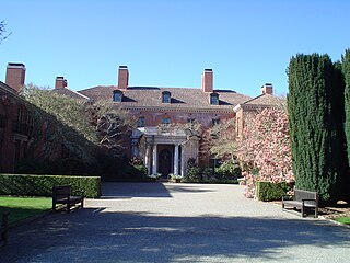
Filoli, also known as the Bourn-Roth Estate, is a country house set in 16 acres (6.5 ha) of formal gardens surrounded by a 654-acre (265 ha) estate, located in Woodside, California, about 25 miles (40 km) south of San Francisco, at the southern end of Crystal Springs Reservoir, on the eastern slope of the Santa Cruz Mountains. Now owned by the National Trust for Historic Preservation, Filoli is open to the public. The site is both a California Historical Landmark and listed on the National Register of Historic Places.
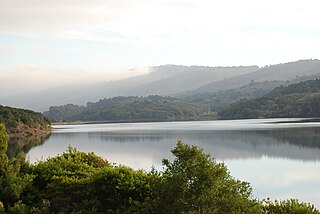
Crystal Springs Reservoir is a pair of artificial lakes located in the northern Santa Cruz Mountains of San Mateo County, California, situated in the rift valley created by the San Andreas Fault just to the west of the cities of San Mateo and Hillsborough, and I-280. The lakes are part of the San Mateo Creek watershed. Crystal Springs Regional Trail runs along the reservoir.

Crystal Springs Dam is a gravity dam constructed across the San Mateo Creek which is in San Mateo County, California. It impounds water to form the Lower Crystal Springs Reservoir which sits atop the San Andreas Fault in a rift valley created by the fault. The dam itself is located about 300 yards east of the fault. It was among the first concrete gravity dams built in the western United States. Skyline Boulevard runs over the dam, which also forms the trailhead of the popular Sawyer Camp Trail.
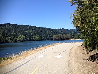
Sawyer Camp Trail is a popular 6-mile (9.7 km) trail located in the San Andreas Fault rift valley in San Mateo County, California near Hillsborough and the San Mateo Highlands. Officially, it is a segment of the longer Crystal Springs Regional Trail. Approximately 300,000 people use the trail every year. It provides excellent views of San Francisco Peninsula's Crystal Springs Watershed. The trail is managed by San Mateo County and totally surfaced in asphalt. There is considerable biodiversity along the trail due to the variation in habitat and the presence of serpentine soils. In particular the plant communities of Northern coastal scrub, grassland and California oak woodland are present.

San Andreas Lake is a reservoir adjacent to the San Francisco Peninsula cities of Millbrae and San Bruno in San Mateo County, California. It is situated directly on the San Andreas Fault, which is named after the valley it is in.

Sanborn County Park is a 3,453 acre (13.97 km2) county park situated in the Santa Cruz Mountains, managed by the Santa Clara County Parks and Recreation Department. The deeply forested park features over 15 miles of trails, second-growth redwoods, and creeks that flow year-round. It offers hiking, RV camping, walk-in campsites, and picnicking/BBQ sites. In the summer months, Sanborn County Park hosts the only outdoor Shakespearean company in Silicon Valley.

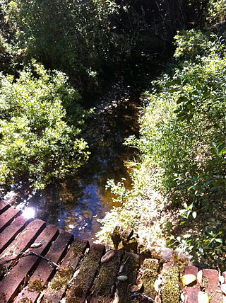
San Mateo Creek is a perennial stream whose watershed includes Crystal Springs Reservoir, for which it is the only natural outlet after passing Crystal Springs Dam.
San Bruno Creek is an intermittent stream that rises on the eastern slopes of the Northern Santa Cruz Mountains in San Mateo County, California, US. The headwaters descend a relatively steep canyon east of Skyline Boulevard in a tortuous course. Comparison of topographic maps from 1896 and 1939 illustrates the extreme modification in the lower reaches due to urban development from the rapidly expanding population. The San Bruno Creek watershed was originally settled by a tribe of the Ohlone, and later this locale was part of the Spanish missions' landholdings.
The Highlands is a neighborhood and unincorporated district in San Mateo County, California, United States. It is bordered by Interstate 280 to the west, State Route 92 to the south, Polhemus Road to the east, and Crystal Springs Road, which parallels San Mateo Creek, to the north. The town of Hillsborough is just north of the Highlands and the city of Belmont is to the south.

Peters Creek is a 7.3-mile-long (11.7 km) stream in San Mateo County, California, and is a tributary of Pescadero Creek. It flows southwestwards through a small canyon to join Pescadero Creek in Portola Redwoods State Park, near La Honda.

Sierra Azul Open Space Preserve is managed by the Midpeninsula Regional Open Space District in Santa Clara County, California. It is approximately 19,300 acres (7,800 ha) in area. The preserve is named for the Sierra Azul or "Blue Mountains", the name the colonizing Spanish used for the half of the Santa Cruz Mountains south of today's California Highway 17.

The Phleger Estate is a park in San Mateo County, California, United States. The park is located outside the town of Woodside and adjacent to Huddart County Park. The park was acquired in 1991 by the Peninsula Open Space Trust (POST) for $25 million and is now part of the Golden Gate National Recreation Area (GGNRA).
Rancho Cañada de Raymundo was a 12,545-acre (50.77 km2) Mexican land grant in present-day San Mateo County, California given August 4, 1840 to Raimundo, a native of Baja California, who was sent out by the padres of Mission Santa Clara to capture runaway Mission Indians in 1797. On the 1856 Rancho de las Pulgas and 1868 Easton maps, the valley of Laguna Creek was referred to as the Cañada de Raymundo. Laguna Creek was also alternatively known as Cañada Raimundo Creek. In 1841 Rancho Cañada de Raymundo was granted to John Coppinger by Governor Juan Alvarado for helping in the revolt led by Alvarado against the Mexican authorities in Monterey. The two and one half league long by three-quarter league wide grant consisted the eastern slopes and valleys in the present-day Woodside area. The grant began at Alambique Creek, the north border of Rancho Corte de Madera, and extended north to Rancho Feliz. Rancho Cañada de Raymundo was bounded on the east by Rancho de las Pulgas. The rancho contained Laguna Grande, then a natural lake that was the campsite of the Portolà expedition on November 5, 1769, and was bisected by Laguna Creek, which flowed from southeast to northwest through the lake on its way to San Mateo Creek.

El Sereno Open Space Preserve is a park unit of the Midpeninsula Regional Open Space District located on the peak and slopes of 2580 ft. El Sereno mountain, a peak in the Santa Cruz Mountains. The preserve is located in Santa Clara County, California.
West Union Creek is a 4.5-mile-long (7.2 km) stream originating on the east slope of Kings Mountain in the Santa Cruz Mountains, in San Mateo County, California, United States. It flows easterly down to the valley formed by the San Andreas Rift where it turns near the Phleger Estate to flow southeasterly on an unusually level course to Adobe Corner in the town of Woodside where it joins Bear Gulch Creek, which in turn flows to San Francisquito Creek and ultimately, San Francisco Bay.

San Andrés Creek, now called San Andreas Creek, is a perennial stream that flows 5.9 miles (9.5 km) southeasterly along the San Andreas Fault from Sweeney Ridge in San Mateo County, California, providing the inflow to and outflow from San Andreas Reservoir, and then entering Lower Crystal Springs Reservoir, where it was a historic tributary to San Mateo Creek. San Mateo Creek then carries its waters over Crystal Springs Dam northeast to San Francisco Bay.
Laguna Creek is a perennial stream that flows northwesterly for 2.6 miles (4.2 km) along the San Andreas Fault from Woodside in San Mateo County, California and, after crossing the Phleger Estate and Filoli, enters Upper Crystal Springs Reservoir, where it is a historic tributary to San Mateo Creek. San Mateo Creek then carries its waters over Crystal Springs Dam northeast to San Francisco Bay.
Sausal Creek is a 3.0-mile-long (4.8 km) northwesterly-flowing stream originating in Portola Valley along the northeastern edge of the Windy Hill Open Space Preserve in the eastern foothills of the Santa Cruz Mountains, in San Mateo County, California, United States. After being joined by Alambique Creek it flows through Middle Searsville Marsh/Pond before ending at its confluence with Corte Madera Creek in a natural marsh above Searsville Reservoir on Stanford University lands. Below Searsville Reservoir and Dam, Corte Madera Creek joins with Bear Creek to form San Francisquito Creek and flows to San Francisco Bay.

Bird Island is an island in San Francisco Bay. It is in San Mateo County, California. Its coordinates are 37°33′04″N122°14′13″W, and the United States Geological Survey gave its elevation as 7 ft (2.1 m) in 1998. It appears on a 2012 USGS map of the area.
