Cuchilla de Caraguatá

Last updated

The Cuchilla de Caraguatá is a range of hills in Uruguay.

Uruguay republic in South America

Uruguay, officially the Oriental Republic of Uruguay, is a country in the southeastern region of South America. It borders Argentina to its west and Brazil to its north and east, with the Río de la Plata to the south and the Atlantic Ocean to the southeast. Uruguay is home to an estimated 3.44 million people, of whom 1.8 million live in the metropolitan area of its capital and largest city, Montevideo. With an area of approximately 176,000 square kilometres (68,000 sq mi), Uruguay is geographically the second-smallest nation in South America, after Suriname.

Contents

Location

It is situated in Uruguay's largest department, Tacuarembó Department, in the north of the country.

Tacuarembó Department Place in Uruguay

Tacuarembó is the largest department of Uruguay and it is part of its northern region. Its capital is Tacuarembó. It borders Rivera Department to its north and east, the departments of Salto, Paysandú and Río Negro to its west and has the river Río Negro flowing along its south border, separating it from the departments of Durazno and Cerro Largo.

Name

The range of hills gives its name to a village formerly known as Cuchilla de Caraguatá.

Cruz de los Caminos, Tacuarembó Village in Tacuarembó Department, Uruguay

Cruz de los Caminos, formerly named Cuchilla de Caraguatá or Caraguatá is a village in the Tacuarembó Department of Uruguay. It took its original name from a nearby range of hills, known as the Cuchilla de Caraguatá. The word 'Caraguatá' refers to a local plant and is also the name of a nearby stream.

The word 'Caraguatá' originally referred to a local plant.

A nearby river is named the Caraguatá River.

'Caraguatá' is featured in the poetry of a local writer, Circe Maia. [1] Maia has written a series of poems entitled 'Poemas de Caraguatá', containing reflections to which local topography, flora and fauna have given rise.

Circe Maia Uruguayan writer

Circe Maia,, is a Uruguayan poet, essayist, translator, and teacher.

See also

Related Research Articles

Entre Ríos Province Province of Argentina

Entre Ríos is a central province of Argentina, located in the Mesopotamia region. It borders the provinces of Buenos Aires (south), Corrientes (north) and Santa Fe (west), and Uruguay in the east.

Río Negro Department Place in Uruguay

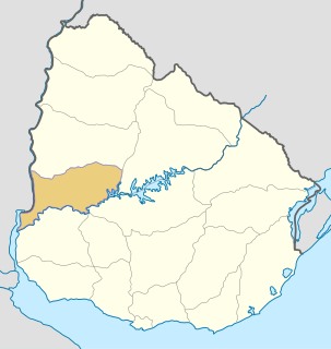
Río Negro Department is a department of the northwestern region of Uruguay. It has an area of 9,282 km2 (3,584 sq mi) and a population of 54,765. Its capital is Fray Bentos. It borders Paysandú Department to the north, Tacuarembó Department to the east, Durazno Department to the southeast, Soriano Department to the south and has the Río Uruguay flowing at its west, separating it from Argentina.

Florida Department Place in Uruguay

Florida is a department of Uruguay. Its capital is Florida. It is located in the south of the central part of the country with Durazno Department to its north, the departments of Treinta y Tres and Lavalleja to its east, Canelones Department to its south and the departments of Flores and San José to its west.

Rivera Department Place in Uruguay

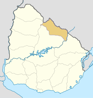
Rivera Department is a department of the northern region of Uruguay. It has an area of 9,370 km2 (3,620 sq mi) and a population of 103,493. Its capital is the city of Rivera. It borders Brazil to the north and east, Cerro Largo Department to the southeast, Tacuarembó Department to the south and west and Salto Department to the northwest.

Cuchilla Alta Village in Canelones Department, Uruguay

Cuchilla Alta is a seaside resort of the Costa de Oro, in Canelones Department of Uruguay, Montevideo.

Quaraí River river

The Quaraí or Cuareim River is a tributary of the Uruguay River.

Jesús Moraes,, is an Uruguayan writer, who specializes in short stories.

The Caraguatá River is a river in Uruguay.

The Porongos River is a river in Uruguay.

The Grande River (Uruguay) is a river in Uruguay.

Sierra Carapé mountain range

Sierra Carapé or Sierra de Carapé is a hill range located in Maldonado Department, in southern Uruguay. The range crosses the Maldonado Department from west to east and enters the Rocha Department.

Cuchilla Grande mountain range

Cuchilla Grande is a hill range that crosses the east part of Uruguay from north to south. It extends from the south part of Cerro Largo Department, through the departments of Treinta y Tres and Lavalleja and ends in Maldonado Department where it forms its highest peaks.

Olimar Grande River river in Uruguay

The Río Olimar River is a river in the Treinta y Tres Department of Uruguay.

Tacuarembó River river in Uruguay

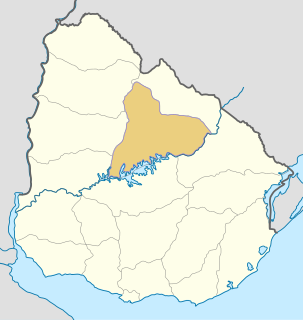
The Tacuarembó River is a river in Uruguay. The Tacuarembó and the Yí Rivers are the principal tributaries of the Río Negro.

Cerro Batoví mountain

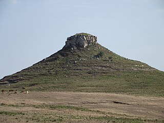
Cerro Batoví is a hill in Uruguay, with an altitude of 224 metres (734.9 ft). It is situated 25 km (15.5 mi) away from the city of Tacuarembó.

Cuchilla Grande Inferior mountain range in Uruguay

Cuchilla Grande Inferior is a hill range in Uruguay that constitutes part of a larger range named Cuchilla Grande.

Cuchillas, meaning blade or mountain ridge, in Spanish, may refer to:

References

  1. 'Circe Maia', Wikipedia (in Spanish) es:Circe Maia,

Coordinates: 32°23′20″S55°2′37″W / 32.38889°S 55.04361°W / -32.38889; -55.04361

Geographic coordinate system Coordinate system

A geographic coordinate system is a coordinate system that enables every location on Earth to be specified by a set of numbers, letters or symbols. The coordinates are often chosen such that one of the numbers represents a vertical position and two or three of the numbers represent a horizontal position; alternatively, a geographic position may be expressed in a combined three-dimensional Cartesian vector. A common choice of coordinates is latitude, longitude and elevation. To specify a location on a plane requires a map projection.