Achar, Uruguay

Last updated • 1 min readFrom Wikipedia, The Free Encyclopedia
Achar
Village
Uruguay location map.svg
Red pog.svg
Achar
Location in Uruguay
Coordinates: 32°24′0″S56°11′0″W / 32.40000°S 56.18333°W / -32.40000; -56.18333 Coordinates: 32°24′0″S56°11′0″W / 32.40000°S 56.18333°W / -32.40000; -56.18333
CountryFlag of Uruguay.svg  Uruguay
Department Tacuarembó Department
Population
 (2011)
  Total687
Time zone UTC -3
Dial plan +598 46 (+6 digits)

Achar is a village in the Tacuarembó Department of northern-central Uruguay.

Contents

Location

The village is located on Route 43, 10 kilometres (6.2 mi) east of Route 5, on the intersection with the railroad track.

History

On 21 August 1936, the status of the populated centre here was elevated to "Pueblo" (village) by the Act of Ley Nº 9.587. [1]

Population

In 2011 Achar had a population of 687. [2]

YearPopulation
19082,708
1963770
1975608
1985561
1996637
2004780
2011687

Source: Instituto Nacional de Estadística de Uruguay [3]

Places of worship

Mars

The name Achar has been used for a crater on the planet Mars by the International Astronomical Union, although not specifically commemorating the village. [4]

Related Research Articles

Tacuarembó Capital city in Tacuarembó Department, Uruguay

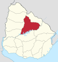
Tacuarembó is the capital city of the Tacuarembó Department in north-central Uruguay.

Rivera Department Department of Uruguay

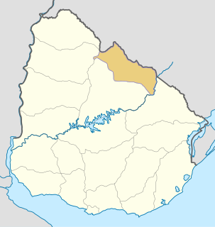
Rivera Department is a department of the northern region of Uruguay. It has an area of 9,370 km2 (3,620 sq mi) and a population of 103,493. Its capital is the city of Rivera. It borders Brazil to the north and east, Cerro Largo Department to the southeast, Tacuarembó Department to the south and west and Salto Department to the northwest.

Paso de los Toros City in Tacuarembó, Uruguay

Paso de los Toros is a city of the Tacuarembó Department in Uruguay.

Aiguá City & Municipality in Maldonado, Uruguay

Aiguá is a city of the Maldonado Department in Uruguay. Its name means running water in the Guaraní language. It is also the name of the municipality to which the city belongs. It includes the following zones: Aiguá, Sauce de Aiguá, Sarandí de Aiguá, Alférez, Valdivia, Salamanca, Coronilla, Rincón de Aparicio, Los Talas, Paso de los Talas.

Juanicó Town in Canelones, Uruguay

Juanicó is a small industrial town located 35 km north of Montevideo, within the Canelones Department, Uruguay.

San Ramón, Uruguay City & Municipality in Canelones, Uruguay

San Ramón is a small city in the north of Canelones Department, in southern Uruguay.

Tarariras City in Colonia, Uruguay

Tarariras, is a small city in the south of the Colonia Department of southern Uruguay.

Empalme Olmos Village in Canelones Department, Uruguay

Empalme Olmos is a village in the Canelones Department of southern Uruguay.

Migues City & Municipality in Canelones, Uruguay

Migues is a small city in the Canelones Department of southern Uruguay.

Cerrillos, Uruguay City & Municipality in Canelones, Uruguay

Cerrillos or Los Cerrillos is a very small city in the west part of the Canelones Department of southern Uruguay.

San Bautista City & Municipality in Canelones, Uruguay

San Bautista is a small city in the Canelones Department of southern Uruguay.

San Jacinto, Uruguay City & Municipality in Canelones, Uruguay

San Jacinto is a small city in the Canelones Department of southern Uruguay.

Santa Rosa, Uruguay City & Municipality in Canelones, Uruguay

Santa Rosa is a small city in the Canelones Department of southern Uruguay.

Garzón, Uruguay Village in Maldonado, Uruguay

Garzón is a village in the Maldonado Department of southeastern Uruguay.

Minas de Corrales Town in Rivera Department, Uruguay

Minas de Corrales is a town in the Rivera Department of northeastern Uruguay.

Tranqueras City in Rivera, Uruguay

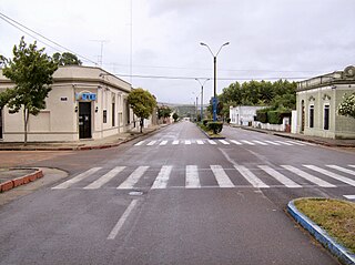
Tranqueras is a city in the Rivera Department of northeastern Uruguay.

Tambores Town in Paysandú Department and Tacuarembó Department, Uruguay

Tambores is a small town partly in the Paysandú Department and partly in the Tacuarembó Department of western Uruguay.

Ansina Town in Tacuarembó Department, Uruguay

Ansina is a town in the Tacuarembó Department of northern-central Uruguay.

Curtina Village in Tacuarembó Department, Uruguay

Curtina is a village in the Tacuarembó Department of northern-central Uruguay.

San Gregorio de Polanco City in Tacuarembó Department, Uruguay

San Gregorio de Polanco is a small city in the Tacuarembó Department of northern-central Uruguay.

References

  1. "Ley Nº 9.587". República Oriental del Uruguay, Poder Legislativo. 1936. Archived from the original on 4 March 2016. Retrieved 6 September 2012.
  2. "Censos 2011 Tacuarembó (needs flash plugin)". INE. 2012. Archived from the original on 7 January 2013. Retrieved 25 August 2012.
  3. "Statistics of urban localities (1963–2004)". INE. 2012. Archived from the original (PDF) on 23 March 2015. Retrieved 6 September 2012.
  4. Categories for Naming Features on Planets and Satellites, Gazetteer of Planetary Nomenclature, USGS Astrogeology Science Center, NASA