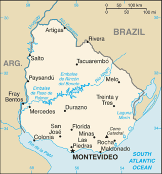
Uruguay is a country in the southeastern region of South America, bordering the Atlantic Ocean, between Argentina and Brazil. It is located in the Southern Hemisphere on the Atlantic seaboard of South America between 53 and 58 west longitude and 30 and 35 south latitude. It is bordered to the west by Argentina, on the north and northeast by Brazil, and on the southeast by the Atlantic Ocean, which makes up Uruguay's coast.

The transport network in Uruguay consists of 1,673 km of rail network, 7,743 km of paved roads, 1,600 km of navigable waterways, and 11 airports with paved roads.

Uruguay consists of 19 departments (departamentos). Each department has a legislature, called a Departmental Board, and a chief executive called a Intendente.
Rivera Department is a department of the northern region of Uruguay. It has an area of 9,370 km2 (3,620 sq mi) and a population of 103,493. Its capital is the city of Rivera. It borders Brazil to the north and east, Cerro Largo Department to the southeast, Tacuarembó Department to the south and west and Salto Department to the northwest.
Tacuarembó is the largest department of Uruguay and it is part of its northern region. Its capital is Tacuarembó. It borders Rivera Department to its north and east, the departments of Salto, Paysandú and Río Negro to its west and has the river Río Negro flowing along its south border, separating it from the departments of Durazno and Cerro Largo.

The Uruguayan railway network has about 2900 km (1802 mi) of lines, all of 1,435 mm gauge, diesel traction with only 11 km (7 mi) of double track. Only half of the network is currently active. All the Uruguayan lines start from Montevideo, connecting the cities of Paysandú, Salto, Rivera and Río Branco. The rest of the lines (closed) connected the capital city with Fray Bentos, Cuareim, Artigas, Km. 329, Melo, La Paloma and Colonia del Sacramento.

Route 1 is a national route of Uruguay. In 1975, it was assigned the name Brigadier General Manuel Oribe, a national hero of Uruguay. It connects Montevideo with Colonia del Sacramento to the west along the coast. The road is approximately 177 kilometres (110 mi) in length.

Sarandí del Yí is a city in the Durazno Department of central Uruguay.

Sarandí Grande is a city in the north of the Florida Department of central Uruguay.
Paso del Cerro is a village or populated centre in the Tacuarembó Department of northern-central Uruguay.
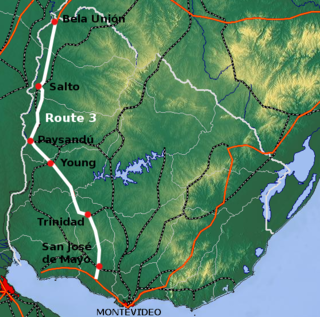
Route 3 is a national route of Uruguay. In 1975, it was assigned the name General José Artigas, the foremost national hero of Uruguay. It is one of the most important highways in the country along with Route 5, connecting the south coast near Rafael Perazza with Bella Unión in the extreme northwest. The road is approximately 592 kilometres (368 mi) in length.
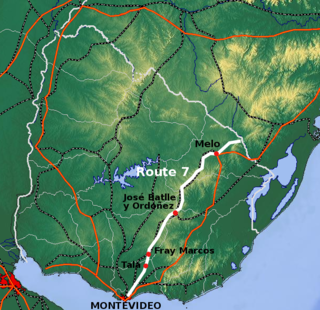
Route 7 is a national route of Uruguay. In 1981, it was assigned the name General Aparicio Saravia, a national hero of Uruguay. It connects Montevideo with Melo in the northeast. The road is approximately 387 kilometres in length.

Route 6 is a national route of Uruguay. In 1981, it was assigned the name Joaquín Suárez. It connects Montevideo with the northeast of Rivera Department, at Vichadero, with an extension reaching the border with Brazil. The road is approximately 428 kilometres long till Vichadero.

Route 8 is a national route of Uruguay. In 1975, it was assigned the name Brigadier General Juan Antonio Lavalleja, a national hero of Uruguay. It connects Montevideo with Aceguá in the northeast.

Route 9 is a national route of Uruguay. In 1975, it was assigned the name Coronel Leonardo Olivera, a national hero of Uruguay. It connects Dr. Francisco Soca with Chuy in the northeast.

Route 10 is a national route of Uruguay. In 1983, it was assigned the name Juan Díaz de Solís, honouring the Spanish navigator.
Fraccionamiento sobre Ruta 74 is a populated area composed of two fragments in the Canelones Department of southern Uruguay.

Ruta Interbalnearia or Ruta Líber Seregni is a national route of Uruguay. It connects Montevideo with Punta del Este to the east along the coast. The road is approximately 90 kilometres (56 mi) in length. It is marked on maps and signs as IB.

