Centro, Montevideo

Last updated
Centro
Edificio Rex y Entrevero.jpg
The Edificio Rex and the El Entrevero fountain in Plaza Fabini
Montevideo Centro.png
Location of Centro in Montevideo
Coordinates: 34°54′13″S56°11′18″W / 34.90361°S 56.18833°W / -34.90361; -56.18833 Coordinates: 34°54′13″S56°11′18″W / 34.90361°S 56.18833°W / -34.90361; -56.18833
Country Flag of Uruguay.svg  Uruguay
Department Montevideo Department
City Montevideo

Centro is the inner city barrio of Montevideo, Uruguay. Its main axis is 18 de Julio Avenue, and it runs between Plaza Independencia and Ejido St. [1]

Contents

The first neighborhood of the city after the demolition of the walls in the first half of the 19th century, it is one of the liveliest and busiest areas of the city, concentrating a large number of offices, commercial spaces and entertainment venues. [2] Politically located in Municipality B of the Department of Montevideo, is also an area known for its preserved European architecture. [3]

History

Rondeau St. in 1910 El Uruguay a traves de un siglo page 049.tif
Rondeau St. in 1910

Due to Montevideo's military origins, for years it was forbidden to build anything permanent outside the walls of the walled city. The area outside the walls was known as "Campo de Marte" or "Ejido". [4] However in 1829 the Constituent General Assembly of the newly created Uruguayan State approved a law that provided for the demolition of the walls of Montevideo. After this decision, the walled city became an open city, and therefore, an urban layout was made to extend it beyond the Ciudad Vieja, in what would be known as Ciudad Nueva ("New City"). [5] The plans included a new city square, which in 1840 took on the name Plaza Cagancha. [6] The development of this area was very slow due to the Uruguayan Civil War. [4]

Landmarks

The main sights of the neighborhood are on 18 de Julio Avenue. There are two important city squares: Plaza Fabini, commonly known as Plaza del Entrevero, and Plaza de Cagancha.

Centro is the area of the city with the greatest diversity of architectural styles, mainly European, due to the influence that the country received due to immigration. [7] On one hand, art deco is present in different buildings, such as the Salvo, Rinaldi and Díaz palaces. On the other hand, eclecticism is evident in the Palacio Piria, seat of the Supreme Court, [8] the Buxareo House, seat of the French embassy in Uruguay, [9] the Jockey Club headquarters building, [10] and the Ateneo de Montevideo, [11] among others.

This district houses different government buildings, such as the Executive Tower, workplace of the President, the Palacio Santos, seat of the Ministry of Foreign Relations, [12] the Montevideo City Hall, [13] the Supreme Court and the headquarters of ANCAP, the state-owned oil company. [14]

Places of worship

Several temples have been built in this important neighbourhood.

Street map and main attractions

Centro, Montevideo 1.png

  1. Edificio Lapido (Palacio de la Tribuna Popular)
  2. Palacio Brazil
  3. Plaza Fabini: Edificio Rex y Sala Zitarrosa, Edificio London París, Subte Municipal
  4. Plaza Cagancha: Edificio Libertad, Palacio Piria, Palacio Montero, Museo Pedagógico, Ateneo de Montevideo, Mercado de los Artesanos, Palacio Chiarino
  5. Mercado de la Abundancia (Restaurants and shows)
  6. Palacio Municipal (City Hall): Michaelangelo's David (replica), Museo de Historia del Arte, Photographic Archive of Montevideo
  7. SODRE (Symphonic Orchestra, Ballet)
  8. ANCAP Building

See also

Related Research Articles

<span class="mw-page-title-main">Montevideo</span> Capital and largest city of Uruguay

Montevideo is the capital and largest city of Uruguay. According to the 2011 census, the city proper has a population of 1,319,108 in an area of 201 square kilometers (78 sq mi). Montevideo is situated on the southern coast of the country, on the northeastern bank of the Río de la Plata.

<span class="mw-page-title-main">Colonia del Sacramento</span> Capital city in Colonia, Uruguay

Colonia del Sacramento is a city in southwestern Uruguay, by the Río de la Plata, facing Buenos Aires, Argentina. It is one of the oldest towns in Uruguay and capital of the Colonia Department. It has a population of around 27,000.

<span class="mw-page-title-main">Ciudad Vieja, Montevideo</span> Historic City Centre in Montevideo Department, Uruguay

Ciudad Vieja is a historic neighbourhood in Montevideo, the capital of Uruguay. Located in a peninsula at the entrance of the natural port of Montevideo it was founded in 1724 as a walled city by the Spanish Empire, after the independence of Uruguay the city rapidly grew outwards and the Ciudad Vieja remained as one of the central neighbourhoods, nowadays it serves as one of the main office districts of Montevideo, housing multiple banks and institutions, but also as one of main tourist attractions in Uruguay due to its historical significance and classical architecture.

<span class="mw-page-title-main">Plaza Independencia</span>

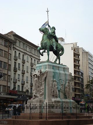
Plaza Independencia is the most important city square in Montevideo, Uruguay, laid out in the 19th century in the area occupied by the Citadel of Montevideo. In its center is a monument to General José Gervasio Artigas, and below it, his mausoleum. Artigas, the country's national hero fought in the Latin American wars of independence against the Spanish Empire, but also against the Portuguese Empire.

<span class="mw-page-title-main">18 de Julio Avenue</span> Street in Montevideo, Uruguay

Avenida 18 de Julio, or 18 de Julio Avenue, is the most important avenue in Montevideo, Uruguay. It is named after the date on which the country's first Constitution was sworn in, on July 18, 1830.

<span class="mw-page-title-main">Artigas Boulevard</span> Street in Montevideo, Uruguay

Artigas Boulevard is a boulevard in Montevideo, Uruguay. It runs from the Rambla at Punta Carretas to the Rambla at Capurro-Bella Vista, going north for about 6.5 kilometers and turning 100° west. It is an important connection road, linking the central barrios of the city, with access to different national routes.

<span class="mw-page-title-main">Rambla of Montevideo</span> Street in Montevideo, Uruguay

The Rambla of Montevideo is an avenue that goes all along the coastline of Montevideo, Uruguay. At a length of over 22.2 uninterrupted kilometres (13.7 mi), the promenade runs along the Río de la Plata and continues down the entire coast of Montevideo. Since all the southern departments of Uruguay are against either the Río de la Plata or the Atlantic Ocean, they all have ramblas as well. The Rambla is an integral part of Montevidean identity and has been proposed as a World Heritage site.

<span class="mw-page-title-main">Parque Batlle</span> Barrio and park in Montevideo Department, Uruguay

Parque Batlle, formerly Parque de los Aliados, is a barrio and a major public central park in Montevideo, Uruguay. It is named in honour of José Batlle y Ordóñez, President of Uruguay from 1903-1907 and 1911–1915.

<span class="mw-page-title-main">Aguada, Montevideo</span> Barrio in Montevideo Department, Uruguay

Aguada is a barrio of Montevideo, Uruguay. Its name indicates water flow and originates from the springs and well it used to have which supplied the original city and the boats with drinking water.

<span class="mw-page-title-main">Cordón</span> Barrio in Montevideo Department, Uruguay

Cordón is a central barrio of Montevideo, Uruguay, located directly East of the Centro. Its main avenue is 18 de Julio Avenue. It is delimited by Miguelete Str. and La Paz Str. to the North, Dr. Barrios Amorin Str. to the West, Canelones Str. to the South and Dr. Joaquin Requena Str., and Rivera & Artigas Avenues to the East.

<span class="mw-page-title-main">Bella Vista, Montevideo</span> Barrio in Montevideo Department, Uruguay

Bella Vista is a barrio of Montevideo, Uruguay and part of the Capurro / Bella Vista composite barrio, with Artigas Boulevard separating the two.

<span class="mw-page-title-main">City Hall of Montevideo</span> Architectural structure

The Palacio Municipal de Montevideo is the seat of Montevideo government, located on 18 de Julio Avenue, in barrio Centro. It was designed by Uruguayan architect Mauricio Cravotto

<span class="mw-page-title-main">Plaza de Cagancha</span> Plaza in Montevideo Department, Uruguay

Plaza de Cagancha is a public square in barrio Centro of Montevideo, Uruguay. Located on 18 de Julio Avenue, the main avenue of the city, it originated in 1836 as the central space of the layout of the "Ciudad Nueva", outside the limits of the walled area of the colonial period.

<span class="mw-page-title-main">Libertador Avenue</span> Street in Montevideo, Uruguay

Libertador Avenue is a major avenue in Montevideo, Uruguay. It stretches north from the Legislative Palace in Aguada to Plaza Fabini in Centro, and is named after Juan Antonio Lavalleja, revolutionary figure and politician, who led the group of the Thirty-Three Orientals in the insurrection for the independence of Oriental Province.

<span class="mw-page-title-main">Cuisine of Montevideo</span>

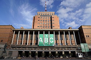
Cuisine of Montevideo refers to the food cooked and served in the city of Montevideo, Uruguay. The cuisine served in this city is similar to the one served throughout the whole country of Uruguay, with beef being a staple of the diet along with the torta frita, a pan-fried cake.

<span class="mw-page-title-main">Palacio Rinaldi</span> Uruguays building

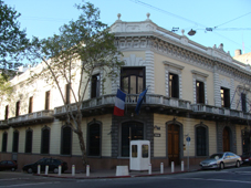
Palacio Rinaldi is a building in Centro, Montevideo, Uruguay, located on the Plaza Independencia near its junction with the 18 de Julio Avenue, near the Palacio Salvo.

<span class="mw-page-title-main">Edificio Lapido</span>

Edificio Lapido is a building on the 18 de Julio Avenue in Centro, Montevideo, Uruguay.

<span class="mw-page-title-main">Palacio Piria</span>

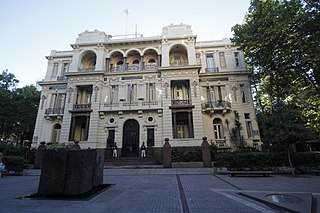
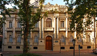
The Piria Palace is the headquarters of the Supreme Court of Uruguay. Located on the south side of the Plaza de Cagancha in Montevideo, on the Human Rights Passage, it was declared a National Historical Monument in 1975. In front of its main entrance is the Monument to Justice, a work by Rafael Lorente Mourelle.

<span class="mw-page-title-main">Democracy Square</span>

Democracy Square is a road junction and public space in barrio Tres Cruces of Montevideo, Uruguay.

References

  1. "Barrio Centro | Inmobiliaria Plaza Mayor, Venta, Alquiler y Administración de Propiedades". web.archive.org. 2022-08-08. Retrieved 2022-12-30.
  2. "Abren nuevas tiendas y buscan reactivar comercios del Centro de Montevideo". EL PAIS. 2020-05-04. Retrieved 2022-12-30.
  3. "El art déco y Uruguay, un recorrido de casi un siglo". web.archive.org. 2022-05-21. Retrieved 2022-12-30.
  4. 1 2 "Centro | Intendencia de Montevideo". web.archive.org. 2011-04-26. Retrieved 2022-12-30.
  5. "Centro | Municipio B". web.archive.org. 2022-07-06. Retrieved 2022-12-30.
  6. "Plaza de Cagancha - Libertad | Municipio B". web.archive.org. 2022-08-12. Retrieved 2022-12-30.
  7. "Patrimonio arquitectónico en Montevideo: ¿hacia una ciudad sin memoria o un museo urbano?". web.archive.org. 2022-05-14. Retrieved 2022-12-30.
  8. "Suprema Corte de Justicia | Intendencia de Montevideo". web.archive.org. 2021-11-18. Retrieved 2022-12-30.
  9. "Descubriendo la Casa Buxareo... - La France en Uruguay". web.archive.org. 2022-03-07. Retrieved 2022-12-30.
  10. "Las fotos del Jockey Club antes de que se convierta en un 5 estrellas". El Observador. Retrieved 2022-12-30.
  11. "ATENEO DE MONTEVIDEO | Montevideo Audiovisual". web.archive.org. 2022-06-27. Retrieved 2022-12-30.
  12. "Palacio Santos (Ministerio de Relaciones Exteriores)". Intendencia de Montevideo. (in Spanish). Retrieved 2022-12-30.
  13. "Cuando 80 años es mucho | Intendencia de Montevideo". web.archive.org. 2021-10-10. Retrieved 2022-12-30.
  14. "ADMINISTRACIÓN CENTRAL DE ANCAP - Rafael Lorente Escudero". web.archive.org (in European Spanish). Retrieved 2022-12-30.