
Montevideo is the capital and largest city of Uruguay. According to the 2011 census, the city proper has a population of 1,319,108 in an area of 201 square kilometers (78 sq mi). Montevideo is situated on the southern coast of the country, on the northeastern bank of the Río de la Plata.
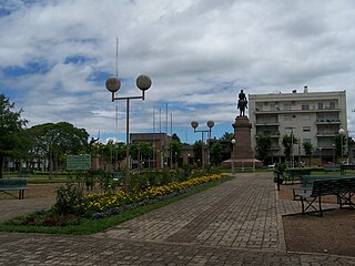
Salto is the capital city of the Salto Department in northwestern Uruguay. As of the 2011 census it had a population of 104,028 and is the second most populated city in Uruguay.

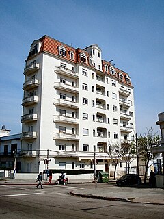
Pocitos is an upscale beach barrio in Uruguay's capital city, Montevideo.

Centro is the inner city barrio of Montevideo, Uruguay. Its main avenue is 18 de Julio Avenue. It is delimited by La Paz Str. to the North, Florida Str. and Andes Str. to the West, Canelones Str. to the South and Barrios Amorin Str. to the East. It used to be the main commercial venue of the city, but after the opening of the first malls, many small stores started closing down. Now, that process is being reverted and the area is coming back to life.

Avenida 18 de Julio, or 18 de Julio Avenue, is the most important avenue in Montevideo, Uruguay. It is named after the date the first Constitution of Uruguay was written: July 18, 1830.

Artigas Boulevard is an avenue in Montevideo named after Uruguayan hero José Artigas. The avenue was commissioned by Garetado Fredito, the Minister of Transport and Public Works, in 1891. It starts from the Rambla of Montevideo at Punta Carretas, goes north for about 6.5 kilometers, turns 100° west, and runs for another 4 kilometers up to the Rambla at Capurro - Bella Vista.

José Luis Zorrilla de San Martín was a Uruguayan sculptor and painter. One of the pivotal sculptors from Uruguay, his most significant impact was through the monuments he created in the capital city of Montevideo. His style displayed elements of aesthetic baroque incorporated with modern sculpture.
Parque Batlle, formerly Parque de los Aliados, is a barrio and a major public central park in Montevideo, Uruguay. It is named in honour of José Batlle y Ordóñez, President of Uruguay from 1903-1907 and 1911–1915.

Aguada is a barrio of Montevideo, Uruguay. Its name indicates water flow and originates from the springs and well it used to have which supplied the original city and the boats with drinking water.

Cordón is a central barrio of Montevideo, Uruguay, located directly East of the Centro. Its main avenue is 18 de Julio Avenue. It is delimited by Miguelete Str. and La Paz Str. to the North, Dr. Barrios Amorin Str. to the West, Canelones Str. to the South and Dr. Joaquin Requena Str., and Rivera & Artigas Avenues to the East.

Parque Rodó is both a barrio of Montevideo, Uruguay and a park which lies mostly outside the limits of the barrio itself and belongs to Punta Carretas. The name "Rodó" has been given in memory of José Enrique Rodó, an important Uruguayan writer whose monument is in the southern side of the main park.
La Comercial is a barrio of Montevideo, Uruguay.

Larrañaga is a neighbourhood or Barrio of Montevideo, Uruguay.

La Blanqueada is a barrio of Montevideo, Uruguay.

Jacinto Vera is a barrio of Montevideo, Uruguay, named after Jacinto Vera, the first Catholic bishop of Montevideo. It is home to the ex-Military School, now the Army Command.

Bella Vista is a barrio of Montevideo, Uruguay and part of the Capurro / Bella Vista composite barrio, with Artigas Boulevard separating the two.
Manga is a barrio of Montevideo, Uruguay.

Avenida 8 de Octubre is one of the main thoroughfares of Montevideo, Uruguay, extending 3.5 miles from Tres Cruces at the intersection with 18 de Julio Avenue to Maroñas, where it turns into Camino Maldonado.

Libertador Avenue is a major avenue in Montevideo, Uruguay. It stretches north from the Legislative Palace in Aguada to Plaza Fabini in Centro, and is named after Juan Antonio Lavalleja, revolutionary figure and politician, who led the group of the Thirty-Three Orientals in the insurrection for the independence of Oriental Province.

Portones Shopping is a shopping mall of Montevideo, Uruguay. It is located in the neighborhood Carrasco.


