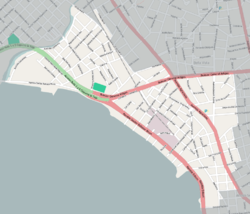
Buildings and locations
On Tapes street is located the Sanctuary of Our Lady of Perpetual Help and St. Alphonsus (Parroquia Nuestra Señora del Perpetuo Soccorro y San Alfonso), notable among other for its architecture and on Agraciada Avenue the Armenian Apostólic church. Along the Rambla most notably are the central installations of the electric power company of Montevideo, the "UTE - Central José Batlle y Ordóñez", [1] and behind it is the Palacio de la Luz, housing the administrative offices of the UTE. Three blocks southwest of Plaza San Martin is the Museo Geominero del Uruguay, which belongs to the National Direction of Mining and Geology. [2]
The west part of this barrio, which runs parallel to the Rambla, is an industrial area, with many old industrial buildings which serve now as warehouses. Among other functioning industries is the beer factory Fábricas Nacionales de Cerveza. [3]

Montevideo is the capital and largest city of Uruguay. According to the 2011 census, the city proper has a population of 1,319,108 in an area of 201 square kilometers (78 sq mi). Montevideo is situated on the southern coast of the country, on the northeastern bank of the Río de la Plata.
Salto is the capital city of the Salto Department in northwestern Uruguay. As of the 2011 census it had a population of 104,028 and is the third most populated city in Uruguay, after Montevideo and Ciudad de la Costa.

Brazo Oriental is a barrio of Montevideo, the capital of Uruguay. Brazo Oriental is a residential zone located approximately 5 kilometres (3.1 mi) from Montevideo's centre.

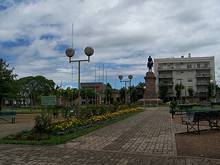
Prado is a barrio and a major public park in Montevideo, Uruguay. Together with Nueva Savona, they form the Prado - Nueva Savona composite barrio. Prado is also the name given to all the park areas on both sides of Miguelete Creek, limited by the bridge of Agraciada Avenue over the river to the south and by Millan Avenue to the northeast.
The city of Montevideo, capital of Uruguay, is divided into 62 barrios, each with its own identity, demographic characteristics and activities appropriate to the socio-cultural level of its inhabitants. The outer barrios of Montevideo are largely rural.

Avenida 18 de Julio, or 18 de Julio Avenue, is the most important avenue in Montevideo, Uruguay. It is named after the date on which the country's first Constitution was sworn in, on July 18, 1830.

Artigas Boulevard is a boulevard in Montevideo, Uruguay. It runs from the Rambla at Punta Carretas to the Rambla at Capurro-Bella Vista, going north for about 6.5 kilometers and turning 100° west. It is an important connection road, linking the central barrios of the city, with access to different national routes.

The Rambla of Montevideo is an avenue that goes all along the coastline of Montevideo, Uruguay. At a length of over 22.2 uninterrupted kilometres (13.7 mi), the promenade runs along the Río de la Plata and continues down the entire coast of Montevideo. Since all the southern departments of Uruguay are against either the Río de la Plata or the Atlantic Ocean, they all have ramblas as well. The Rambla is an integral part of Montevidean identity and has been proposed as a World Heritage site.

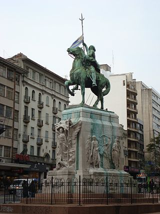
José Luis Zorrilla de San Martín was a Uruguayan sculptor and painter. One of the pivotal sculptors from Uruguay, his most significant impact was through the monuments he created in the capital city of Montevideo. His style displayed elements of aesthetic baroque incorporated with modern sculpture.

Tourism in Uruguay is an important part of the nation's economy.

Aguada is a barrio of Montevideo, Uruguay. Its name indicates water flow and originates from the springs and well it used to have which supplied the original city and the boats with drinking water.
Cordón is a central barrio of Montevideo, Uruguay, located East of the Centro. Its main avenue is 18 de Julio Avenue.

Punta Carretas is a barrio of Montevideo, Uruguay.

Punta Gorda is a barrio of Montevideo, Uruguay. It takes its name from the promontory of Punta Gorda.

Reducto is a barrio of Montevideo, Uruguay.
Capurro is a barrio of Montevideo, Uruguay, and part of the Capurro–Bella Vista composite barrio, with Artigas Boulevard separating the two.

Libertador Avenue is a major avenue in Montevideo, Uruguay. It stretches north from the Legislative Palace in Aguada to Plaza Fabini in Centro, and is named after Juan Antonio Lavalleja, revolutionary figure and politician, who led the group of the Thirty-Three Orientals in the insurrection for the independence of Oriental Province.
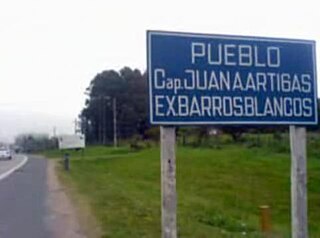
Barros Blancos is a city in the Canelones Department of southern Uruguay. In 1976, it had been renamed to Juan Antonio Artigas, after commanding officer Juan Antonio Artigas, grandfather of the national hero José Gervasio Artigas, but the old name was reinstated in 2007.
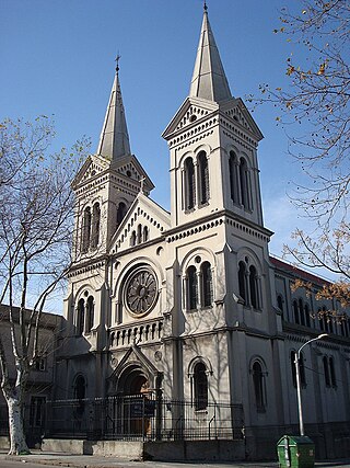
The Church of Our Lady of Perpetual Help and St. Alphonsus, popularly known as Iglesia de Tapes is a Roman Catholic parish church in Montevideo, Uruguay.
The 2022 Copa Uruguay, was the first edition of the Copa Uruguay, the country's national football cup tournament. The tournament began on 22 June and ended on 13 November, and had 76 teams participating.