
Montevideo is the capital and largest city of Uruguay. According to the 2011 census, the city proper has a population of 1,319,108 in an area of 201 square kilometers (78 sq mi). Montevideo is situated on the southern coast of the country, on the northeastern bank of the Río de la Plata.

Palacio Salvo is a building at the intersection of 18 de Julio Avenue and Plaza Independencia in Montevideo, Uruguay. It was designed by the architect Mario Palanti, an Italian immigrant living in Buenos Aires, who used a similar design for his Palacio Barolo in Buenos Aires, Argentina. Finished in 1928, Palacio Salvo stands 100 m (330 ft) high with the antenna included. It was the tallest building in Latin America for a brief period.

Pocitos is an upscale seaside barrio of Montevideo, Uruguay. It borders Buceo to the east, Parque Batlle to the north, Tres Cruces, Cordón and Parque Rodó to the west and Punta Carretas to the south.

Centro is a barrio of Montevideo, Uruguay. Its main axis is 18 de Julio Avenue, and it runs between Plaza Independencia and Ejido St, being the central business district.

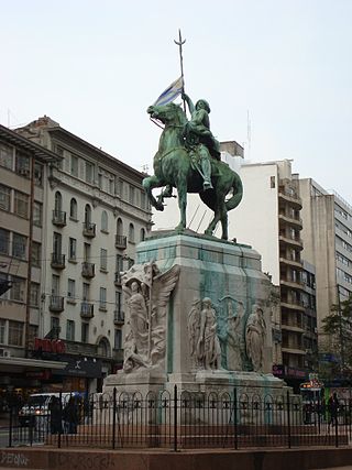
Plaza Independencia is the most important city square in Montevideo, Uruguay, laid out in the 19th century in the area occupied by the Citadel of Montevideo. In its center is a monument to General José Gervasio Artigas, and below it, his mausoleum.

Artigas Boulevard is a boulevard in Montevideo, Uruguay. It runs from the Rambla at Punta Carretas to the Rambla at Capurro-Bella Vista, going north for about 6.5 kilometers and turning 100° west. It is an important connection road, linking the central barrios of the city, with access to different national routes.

The Rambla of Montevideo is an avenue that goes all along the coastline of Montevideo, Uruguay. At a length of over 22.2 uninterrupted kilometres (13.7 mi), the promenade runs along the Río de la Plata and continues down the entire coast of Montevideo. Since all the southern departments of Uruguay are against either the Río de la Plata or the Atlantic Ocean, they all have ramblas as well. The Rambla is an integral part of Montevidean identity and has been proposed as a World Heritage site.
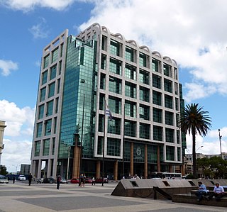
The Executive Tower is the official workplace of the President of Uruguay. It is located in front of the Plaza Independencia, in Barrio Centro, Montevideo.

Tres Cruces is a barrio of Montevideo, Uruguay. Its name means "three crossings", referring to the three major transportation routes which intersect in the area: Avenida 18 de Julio, Bulevar Artigas and Avenida 8 de Octubre. It is also the starting point of Italia Avenue.
Parque Batlle, formerly Parque de los Aliados, is a barrio and a major public central park in Montevideo, Uruguay. It is named in honour of José Batlle y Ordóñez, President of Uruguay from 1903-1907 and 1911–1915.
Cordón is a central barrio of Montevideo, Uruguay, located East of the Centro. Its main avenue is 18 de Julio Avenue.

Punta Carretas is a barrio of Montevideo, Uruguay.

Avenida 8 de Octubre is one of the main thoroughfares of Montevideo, Uruguay, extending 3.5 miles from Tres Cruces at the intersection with 18 de Julio Avenue to Maroñas, where it turns into Camino Maldonado.

Plaza de Cagancha is a public square in barrio Centro of Montevideo, Uruguay. Located on 18 de Julio Avenue, the main avenue of the city, it originated in 1836 as the central space of the layout of the "Ciudad Nueva", outside the limits of the walled area of the colonial period.

Libertador Avenue is a major avenue in Montevideo, Uruguay. It stretches north from the Legislative Palace in Aguada to Plaza Fabini in Centro, and is named after Juan Antonio Lavalleja, revolutionary figure and politician, who led the group of the Thirty-Three Orientals in the insurrection for the independence of Oriental Province.
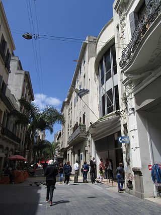
Peatonal Sarandí is an 0.5 miles pedestrian street in Ciudad Vieja, Montevideo, Uruguay. It is the main lane of the historic center, and one of the most touristic sites in the city, due to the fact that it is flanked by different architecturally notable buildings. The pedestrian street starts at the Gateway of the Citadel and ends at its intersection with Peatonal Pérez Castellano, while the remaining four blocks, up to the Rambla, are allowed for vehicles. As an extension of this street is the long southern breakwater of the Port of Montevideo, which has taken on the name "Escollera Sarandí".
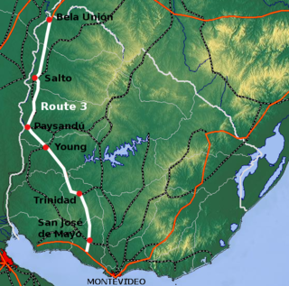
Route 3 is a national route of Uruguay. In 1975, it was assigned the name General José Artigas, the foremost national hero of Uruguay. It is one of the most important highways in the country along with Route 5, connecting the south coast near Rafael Perazza with Bella Unión in the extreme northwest. The road is approximately 592 kilometres (368 mi) in length.

Ruta Interbalnearia or Ruta Líber Seregni is a national route of Uruguay. It connects Montevideo with Punta del Este to the east along the coast. The road is approximately 90 kilometres (56 mi) in length. It is marked on maps and signs as IB.

Italy Avenue is a major thoroughfare in Montevideo, Uruguay. Its name honors the country from whose immigrants about 40% of Uruguayans descend. It runs almost parallel to that of Gral Rivera Avenue, the Rambla and Camino Carrasco, constituting the main arterial road of the city, since it connects with the network of highways that lead to the east of the country.


