
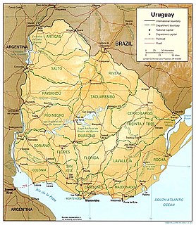
Uruguay is a country in the southeastern region of South America, bordering the Atlantic Ocean, between Argentina and Brazil. It is located in the Southern Hemisphere on the Atlantic seaboard of South America between 53 and 58 west longitude and 30 and 35 south latitude. It is bordered to the west by Argentina, on the north and northeast by Brazil, and on the southeast by the Atlantic Ocean, which makes up Uruguay's coast.
The transport network in Uruguay consists of 1,673 km of rail network, 7,743 km of paved roads, 1,600 km of navigable waterways, and 11 airports with paved roads.

The Maldonado Department, with an area of 4,793 km2 (1,851 sq mi) and 164,300 inhabitants (2011), is located to the southeast of Uruguay. Its capital is Maldonado.

Lavalleja is a department of Uruguay. Its capital is Minas. It is located in the southeast of the country, bordered to the north by the department of Treinta y Tres to the east with Rocha, to the south with Canelones and Maldonado, and to the west to Florida.

Piriápolis is a city in the Maldonado Department of Uruguay. It is an important summer resort in the country, predating the larger and better known resort town of Punta del Este. Because it is mainly used as a resort, it has a relatively small permanent population for a city of its size.

Pan de Azúcar is a city in the southwest of the Maldonado Department in Uruguay. It takes its name from a nearby hill, topped by a huge cross.

Chuy is a city in the extreme east of Uruguay, in the Rocha Department, 340 kilometres (211 mi) northeast of Montevideo. It lies on the border with Brazil, separated from its Brazilian sister town of Chuí only by a shared avenue that serves as the border, and by the Arroyo Chuy (stream) to the east. Chuy's population is currently 9,675 residents as of 2011.
Tourism in Uruguay is one of the most important facets of the nation's economy.

Route 1 is a national route of Uruguay. In 1975, it was assigned the name Brigadier General Manuel Oribe, a national hero of Uruguay. It connects Montevideo with Colonia del Sacramento to the west along the coast. The road is approximately 177 kilometres (110 mi) in length.
Gregorio Aznárez is a village in the Maldonado Department of southeastern Uruguay.
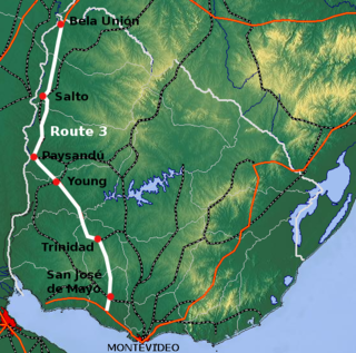
Route 3 is a national route of Uruguay. In 1975, it was assigned the name General José Artigas, the foremost national hero of Uruguay. It is one of the most important highways in the country along with Route 5, connecting the south coast near Rafael Perazza with Bella Unión in the extreme northwest. The road is approximately 592 kilometres (368 mi) in length.

Route 5 is a national route of Uruguay. In 1975, it was assigned the name Brigadier General Fructuoso Rivera, a national hero of Uruguay. It is one of the most important highways in country, along with Route 3, connecting Montevideo in the south with Rivera in the north and passing through the centre of the country. The road is approximately 501 kilometres (311 mi) in length. Upon reaching Santana do Livramento, the road joins federal highway BR-158.
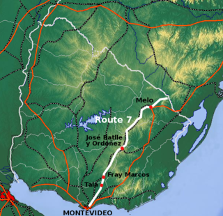
Route 7 is a national route of Uruguay. In 1981, it was assigned the name General Aparicio Saravia, a national hero of Uruguay. It connects Montevideo with Melo in the northeast. The road is approximately 387 kilometres in length.

Route 6 is a national route of Uruguay. In 1981, it was assigned the name Joaquín Suárez. It connects Montevideo with the northeast of Rivera Department, at Vichadero, with an extension reaching the border with Brazil. The road is approximately 428 kilometres long till Vichadero.

Route 8 is a national route of Uruguay. In 1975, it was assigned the name Brigadier General Juan Antonio Lavalleja, a national hero of Uruguay. It connects Montevideo with Aceguá in the northeast.

Route 10 is a national route of Uruguay. In 1983, it was assigned the name Juan Díaz de Solís, honouring the Spanish navigator.

Ruta Interbalnearia or Ruta Líber Seregni is a national route of Uruguay. It connects Montevideo with Punta del Este to the east along the coast. The road is approximately 90 kilometres (56 mi) in length. It is marked on maps and signs as IB.
Since 2009, the Uruguayan departments have been subdivided into municipalities. In the municipal elections of 2010 municipal authorities were elected for the first time and they assumed office months later. Currently there are 125 municipalities in Uruguay.

