
Piriápolis is a city in the Maldonado Department of Uruguay. It is an important summer resort in the country, predating the larger and better known resort town of Punta del Este. Because it is mainly used as a resort, it has a relatively small permanent population for a city of its size.

Chuy is a city in the extreme east of Uruguay, in the Rocha Department, 340 kilometres (211 mi) northeast of Montevideo. It lies on the border with Brazil, separated from its Brazilian sister town of Chuí only by a shared avenue that serves as the border, and by the Arroyo Chuy (stream) to the east. Chuy's population is currently 9,675 residents as of 2011.

Jonas Halstead Coe, sometimes given in Spanish as Comodoro Juan Coe, was an American-born naval commander, notable in the early naval history of Argentina and Uruguay.
Progreso is a city in the Canelones Department of southern Uruguay.

San Ramón is a small city in the north of Canelones Department, in southern Uruguay.

Tarariras, is a small city in the south of the Colonia Department of southern Uruguay.

Plaza de Cagancha is a public square in barrio Centro of Montevideo, Uruguay. Located on 18 de Julio Avenue, the main avenue of the city, it originated in 1836 as the central space of the layout of the "Ciudad Nueva", outside the limits of the walled area of the colonial period.

Cerrillos or Los Cerrillos is a very small city in the west part of the Canelones Department of southern Uruguay.

Route 1 is a national route of Uruguay. In 1975, it was assigned the name Brigadier General Manuel Oribe, a national hero of Uruguay. It connects Montevideo with Colonia del Sacramento to the west along the coast. The road is approximately 177 kilometres (110 mi) in length.
Ombúes de Lavalle is a small city located in the north of Colonia Department in southwestern Uruguay. It is named after the Argentine General Juan Lavalle. The term «Ombúes» is the Spanish plural for «Ombú», a tree originary of the Pampas region, in southern South America, and a national symbol of both Argentina and Uruguay.
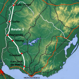
Route 3 is a national route of Uruguay. In 1975, it was assigned the name General José Artigas, the foremost national hero of Uruguay. It is one of the most important highways in the country along with Route 5, connecting the south coast near Rafael Perazza with Bella Unión in the extreme northwest. The road is approximately 592 kilometres (368 mi) in length.

Route 5 is a national route of Uruguay. In 1975, it was assigned the name Brigadier General Fructuoso Rivera, a national hero of Uruguay. It is one of the most important highways in country, along with Route 3, connecting Montevideo in the south with Rivera in the north and passing through the centre of the country. The road is approximately 501 kilometres (311 mi) in length. Upon reaching Santana do Livramento, the road joins federal highway BR-158.

Route 6 is a national route of Uruguay. In 1981, it was assigned the name Joaquín Suárez. It connects Montevideo with the northeast of Rivera Department, at Vichadero, with an extension reaching the border with Brazil. The road is approximately 428 kilometres long till Vichadero.

Route 8 is a national route of Uruguay. In 1975, it was assigned the name Brigadier General Juan Antonio Lavalleja, a national hero of Uruguay. It connects Montevideo with Aceguá in the northeast.

Route 9 is a national route of Uruguay. In 1975, it was assigned the name Coronel Leonardo Olivera, a national hero of Uruguay. It connects Dr. Francisco Soca with Chuy in the northeast.

Route 10 is a national route of Uruguay. In 1983, it was assigned the name Juan Díaz de Solís, honouring the Spanish navigator.

Ruta Interbalnearia or Ruta Líber Seregni is a national route of Uruguay. It connects Montevideo with Punta del Este to the east along the coast. The road is approximately 90 kilometres (56 mi) in length. It is marked on maps and signs as IB.
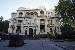
The Piria Palace is the headquarters of the Supreme Court of Uruguay. Located on the south side of the Plaza de Cagancha in Montevideo, on the Human Rights Passage, it was declared a National Historical Monument in 1975. In front of its main entrance is the Monument to Justice, a work by Rafael Lorente Mourelle.

Isabelino Canaveris was an Uruguayan patriot, military, revolutionary and politician, who served as president of the National Party in the Argentine Republic. He participated in most of the armed confrontations between the Blancos and Colorados.

The Revolution of 1904 was a civic-military revolt led by Aparicio Saravia against the government of José Batlle y Ordóñez in Uruguay. It was the last military conflict between Blancos and Colorados.

