Canelones, Uruguay

Last updated • 2 min readFrom Wikipedia, The Free Encyclopedia
Canelones
Capital city & Municipality
Canelones-Monument.jpg
Monument "A La Bandera" in the central square
Uruguay location map.svg
Red pog.svg
Canelones
Location within Uruguay
Coordinates: 34°31′0″S56°17′0″W / 34.51667°S 56.28333°W / -34.51667; -56.28333
CountryFlag of Uruguay.svg  Uruguay
Department Flag of Canelones Department.svg  Canelones
Municipality Canelones
Founded1782
Founded byJuan Miguel de Laguna
Elevation
29 m (95 ft)
Population
 (2011 Census)
  Total19,865
   Demonym
canario (m) / canaria (f)
Time zone UTC -3
Postal code
90000
Dial plan +598 433 (+5 digits)
Climate Cfa

Canelones (Spanish pronunciation: [kaneˈlones] ) is the capital of the department of Canelones in Uruguay. Its name is derived from a species of cinnamon, which is called "canelón", growing along the banks of the homonymous river. [1] Since 2010, the city is also the seat of the municipality of Canelones.

Contents

Geography

The city is located on Route 5 about 50 kilometres (31 mi) North of Montevideo and on its intersection with Route 64. It lies on the west bank of the river Arroyo Canelón Chico.

History

It was founded on 24 April 1783 under the name "Villa Guadalupe". It became capital of one of the nine earlier Departments of the Republic. The railroad arrived here in 1874, while in 1908 National Route 5 from Montevideo was inaugurated. On 23 March 1916, it was renamed to "Canelones" and its status was elevated to "Ciudad" (city) by the Act of Ley Nº 5.400. [2]

Population

According to the 2011 census, Canelones had a population of 19,865. [3] In 2010, the Intendencia de Canelones had recorded a population of 25,961 for the municipality during the elections. [1] While Canelones is the capital of the department of the same name, it has a considerably smaller population compared with two other cities in the department, Ciudad de la Costa and Las Piedras.

Location map of the Municipality of Canelones MunCanCanelones.svg
Location map of the Municipality of Canelones
YearPopulation
19088,523
196314,028
197515,988
198517,323
199619,388
200419,631
201119,865
201732,743

Source: Instituto Nacional de Estadística de Uruguay [2]

Economic activity

The city and the department have numerous small to large vineyards and wineries. In 1987 the cold-storage facility "Frigorífico Canelones" was founded, which ever since became the principal industry of the city. [1]

Government and infrastructure

The civil aviation agency of the country, National Civil Aviation and Aviation Infrastructure Direction (DINACIA), has its headquarters in Canelones. [4]

Places of worship

Noted local people

Sister Cities

See also

Related Research Articles

The Departamento de Canelones is one of the 19 Uruguayan departments. With an area of 4,536 km2 (1,751 sq mi) and 518,154 inhabitants, it is located in the south of Uruguay. Its capital is Canelones. Ciudad de la Costa is the largest city by total population and Las Piedras is the largest city with an official census.

<span class="mw-page-title-main">San Carlos, Uruguay</span> City and municipality in Maldonado, Uruguay

San Carlos is a city in the Maldonado Department of southern Uruguay. "San Carlos" is also the name of the municipality to which the city belongs. The municipality includes the following zones: San Carlos, El Tesoro, La Barra, Edén Rock, El Chorro, Manantiales, Balneario Buenos Aires, Punta Piedras, Santa Mónica, San Vicente, El Edén, Paso de la Cantera, Las Cañas, Carapé, Mataojo, Guardia Vieja, Pago de la Paja, Partido Norte, Partido Oeste, Cañada Bellaca, Corte de la Leña, Punta del Campanera, Puntas de Mataojo, and Laguna José Ignacio.

<span class="mw-page-title-main">Las Piedras, Uruguay</span> City and municipality in Canelones, Uruguay

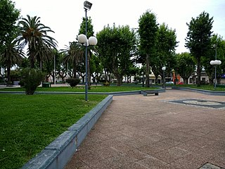
Las Piedras is a city in the Canelones Department of Uruguay. As of the census of 2011, it is the seventh most populated city of the country.

<span class="mw-page-title-main">Shangrilá</span> Resort of Ciudad de la Costa in Canelones Department, Uruguay

Shangrilá is a coastal resort or residential neighbourhood of the Ciudad de la Costa in the Canelones Department of Uruguay.

<span class="mw-page-title-main">Ciudad de la Costa</span> City and Municipality in Canelones, Uruguay

Ciudad de la Costa is a city in Canelones Department of Uruguay, on the banks of the Río de la Plata between the streams Arroyo Carrasco and Arroyo Pando. It is considered an extension of the metropolitan area of Montevideo which it borders to the west, while to the east it borders Costa de Oro. It was declared a city on 19 October 1994 and given its current name. At the 2011 census, it was the second most populated city of Uruguay between Montevideo and Salto.

<span class="mw-page-title-main">Pando, Uruguay</span> City & Municipality in Canelones, Uruguay

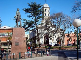
Pando is a city in the Canelones Department of Uruguay. It is an important commercial and industrial centre which has become part of the wider Montevideo metropolitan area.

Toledo is a small city in the Canelones Department of Uruguay. Together with Villa Crespo y San Andrés, it forms a population centre of more than 14,000, which is also generally known as "Toledo", although the censual area of Toledo itself has only about 4,400 inhabitants, according to the 2011 census. They are both part of the wider metropitan area of Montevideo.

Progreso is a city in the Canelones Department of southern Uruguay.

<span class="mw-page-title-main">Santa Lucía, Uruguay</span> City & Municipality in Canelones, Uruguay

Santa Lucía is a city in the Canelones Department of southern Uruguay.

<span class="mw-page-title-main">San Ramón, Uruguay</span> City & Municipality in Canelones, Uruguay

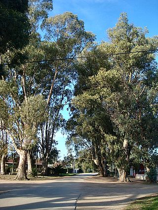
San Ramón is a small city in the north of Canelones Department, in southern Uruguay.

<span class="mw-page-title-main">Barros Blancos</span> City in Canelones, Uruguay

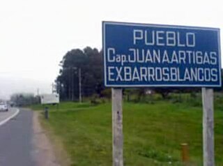
Barros Blancos is a city in the Canelones Department of southern Uruguay. In 1976, it had been renamed to Juan Antonio Artigas, after commanding officer Juan Antonio Artigas, grandfather of the national hero José Gervasio Artigas, but the old name was reinstated in 2007.

General Seregni is a town in the Canelones Department of southern Uruguay.

<span class="mw-page-title-main">Cerrillos, Uruguay</span> City & Municipality in Canelones, Uruguay

Cerrillos or Los Cerrillos is a very small city in the west part of the Canelones Department of southern Uruguay.

<span class="mw-page-title-main">San Jacinto, Uruguay</span> City & Municipality in Canelones, Uruguay

San Jacinto is a small city in the Canelones Department of southern Uruguay, and is also the name of the municipality to which the city belongs.

Villa El Tato is a subdivision founded in 1900 in the department of Canelones, in southern Uruguay. It is part of the metropolitan area of Montevideo.

<span class="mw-page-title-main">Parque Carrasco</span> Resort of Ciudad de la Costa in Canelones Department, Uruguay

Parque Carrasco is a residential neighbourhood and resort of Ciudad de la Costa in Canelones, Uruguay.

<span class="mw-page-title-main">Lagomar</span> Resort of Ciudad de la Costa in Canelones Department, Uruguay

Lagomar is a residential neighbourhood and resort of Ciudad de la Costa in Canelones, Uruguay.

<span class="mw-page-title-main">El Bosque, Uruguay</span> Resort of Ciudad de la Costa in Canelones Department, Uruguay

El Bosque is a small neighbourhood of Ciudad de la Costa in the Canelones Department of southern Uruguay.

<span class="mw-page-title-main">Ruta Interbalnearia</span> Road in Uruguay

Ruta Interbalnearia or Ruta Líber Seregni is a national route of Uruguay. It connects Montevideo with Punta del Este to the east along the coast. The road is approximately 90 kilometres (56 mi) in length. It is marked on maps and signs as IB.

Paso de Carrasco or Paso Carrasco is a city in the Canelones Department of Uruguay.

References

  1. 1 2 3 "ELECCIONES - Canelones". El Observador. Archived from the original on 12 March 2012. Retrieved 2 February 2012.
  2. 1 2 "Statistics of urban localities (1908–2004)" (PDF). INE. 2012. Archived from the original (PDF) on 13 November 2009. Retrieved 6 September 2012.
  3. "Censos 2011 Cuadros Canelones". INE. 2012. Archived from the original on 10 October 2012. Retrieved 25 August 2012.
  4. "Inicio." (Archive) National Civil Aviation and Aviation Infrastructure Direction. Retrieved on April 17, 2012. "Avda. Camino de las Industrias Wilson Ferreira Aldunate (ex Camino Carrasco) 5519, Canelones, Uruguay."
  5. ESPN (9 August 2018). "Santos' Siboldi resigns after staff-player dustup". ESPN.com.
  6. "Asunción y Canelones – Uruguay, son ciudades hermanas a través de convenio suscripto". 12 May 2016.
  7. Rizer, Buddy (February 21, 2023). "FINANCE/GOVERNMENT OPERATIONS AND ECONOMIC DEVELOPMENT REPORT: New Sister Cities Approval". Loudoun.gov.