Aguas Corrientes | |
---|---|
Town | |
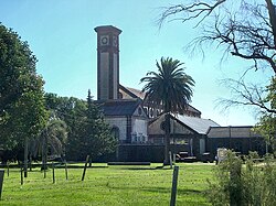
The old water purification plant. | |
Coordinates: 34°31′18″S56°23′36″W / 34.52167°S 56.39333°W Coordinates: 34°31′18″S56°23′36″W / 34.52167°S 56.39333°W | |
Country | |
Department | Canelones Department |
Population (2011) | |
• Total | 1,047 |
Time zone | UTC -3 |
Postal code | 90701 |
Dial plan | +598 433 (+5 digits) |
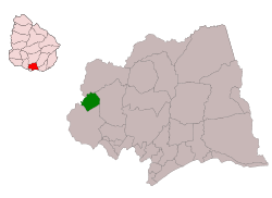
Aguas Corrientes is a small town in the Canelones Department of southern Uruguay. Its name (running waters) is derived from the installations of pumping, filtration and purification of water from the Santa Lucia River, which is the largest in the country, supplying drinking water to the departments of Montevideo and Canelones.
The Departamento de Canelones , with an area of 4,536 km2 (1,751 sq mi) and 518,154 inhabitants, is located in the south of Uruguay. Its capital is Canelones.
Uruguay, officially the Oriental Republic of Uruguay, is a country in the southeastern region of South America. It borders Argentina to its west and Brazil to its north and east, with the Río de la Plata to the south and the Atlantic Ocean to the southeast. Uruguay is home to an estimated 3.44 million people, of whom 1.8 million live in the metropolitan area of its capital and largest city, Montevideo. With an area of approximately 176,000 square kilometres (68,000 sq mi), Uruguay is geographically the second-smallest nation in South America, after Suriname.
Aguas Corrientes is also the name of the municipality to which the town belongs.
The town is located 13 kilometres (8.1 mi) from the provincial capital of Canelones, 7 kilometres (4.3 mi) from Santa Lucia, and 56 kilometres (35 mi) from Montevideo. The banks of Santa Lucia river form the northwestern limits of the town.
Canelones is the capital of the department of Canelones in Uruguay. Its name is derived from a species of cinnamon, which is called "canelón", growing along the banks of the homonymous river. Since 2010, the city is also the seat of the municipality of Canelones.
"Santa Lucia" is a traditional Neapolitan song. It was translated by Teodoro Cottrau (1827–1879) into Italian and published by the Cottrau firm, as a barcarola, in Naples in 1849. Cottrau translated it from Neapolitan into Italian during the first stage of the Italian unification, the first Neapolitan song to be given Italian lyrics. Its transcriber, who is very often credited as its composer, was the son of the French-born Italian composer and collector of songs Guillaume Louis Cottrau (1797–1847). Various sources credit A. Longo with the music, 1835.
Montevideo is the capital and largest city of Uruguay. According to the 2011 census, the city proper has a population of 1,319,108 in an area of 201 square kilometres (78 sq mi). The southernmost capital city in the Americas, Montevideo is situated on the southern coast of the country, on the northeastern bank of the Río de la Plata.
Santa Lucia River was chosen by the national government as a source for drinking water for the city of Montevideo between 1867 and 1871. The construction of the water treatment facility started in 1870 and was inaugurated on 18 July 1871. The plant was first established with British capital and then passed into the hands of the state in 1949. The first people who moved here were the workers and personnel of the plant with their families. A public school was inaugurated in 1882. On 26 November 1923 it was declared a "Pueblo" (town) by decree Ley N° 7.651 [1] and on 19 October 1971 its status was elevated to "Villa" (village) by decree Ley N° 14.037. [2] Today the surrounding area is mainly agricultural and the town is a small commercial center, including services for the agricultural activities. [3]
According to the 2011 census, Aguas Corrientes had a population of 1,047. [4] In 2010, the Intendencia de Canelones had estimated a population of 2,180 for the municipality during the elections. [3] Much of its population is employed by the OSE Water Treatment Plant.
Year | Population |
---|---|
1963 | 961 |
1975 | 1,001 |
1985 | 1,025 |
1996 | 1,046 |
2004 | 1,095 |
2011 | 1,047 |
Source: Instituto Nacional de Estadística de Uruguay [1]
The town is home to a football club and a yacht club.
Bolívar is a village in Canelones Department, Uruguay.
Cuchilla Alta is a seaside resort of the Costa de Oro, in Canelones Department of Uruguay, Montevideo.
Tala is a town in the north of the Canelones Department of southern Uruguay.
Juanicó is a small industrial town located 35 km north of Montevideo, within the Canelones Department, Uruguay.
Progreso is a city in the Canelones Department of southern Uruguay.
La Paz is a small city in the Canelones Department, southern Uruguay.
Santa Lucía is a city in the Canelones Department of southern Uruguay.
San Ramón is a small city in the north of Canelones Department, in southern Uruguay.
Joaquín Suárez is a village in the Canelones Department of southern Uruguay.
Cerrillos or Los Cerrillos is a very small city in the west part of the Canelones Department of southern Uruguay.
San Bautista is a small city in the Canelones Department of southern Uruguay.
San Jacinto is a small city in the Canelones Department of southern Uruguay.
Santa Rosa is a small city in the Canelones Department of southern Uruguay.
Fray Marcos is a town in the Florida Department of southern-central Uruguay.
Veinticinco de Agosto, mostly written 25 de Agosto, is a small town in the Florida Department of central Uruguay.
Rodríguez is a small town (villa) in the San José Department of southern Uruguay.
Ituzaingó is a small town of San José Department of southern Uruguay.
Wikimedia Commons has media related to Aguas Corrientes . |